Skip to content

Next Storm/Next Snow Forecast Discussion from the Cherrywood Observatory – July 13-14, 2019

This content was originally published by the Longmont Observer and is licensed under a Creative Commons license.

In Brief:

A little bit of tropical moisture is leaking into the state up the Rockies under an upper level ridge that will strengthen and weaken, off and on, this week. The low to mid 90's and a daily chance of afternoon storms will be the norm. The summer doldrums are here.

Forecast Discussion:

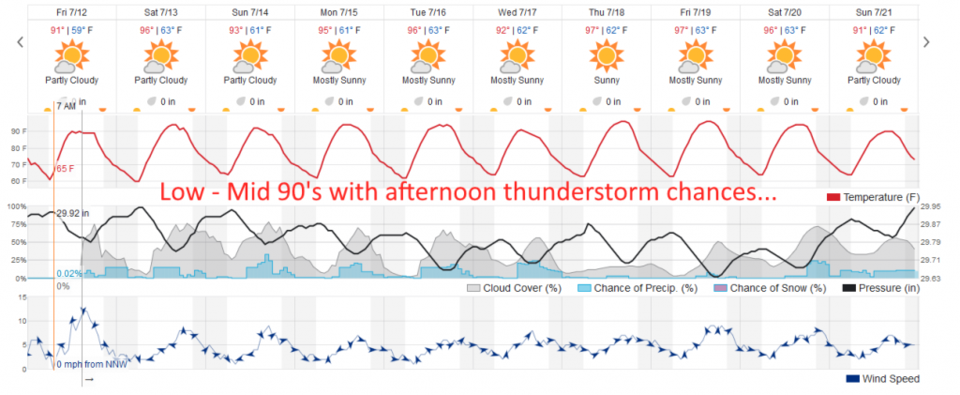
I can't add much to the In Brief this time. We will see afternoon storm chances (non severe) and mid 90's F this weekend (Figure 1). Remember, lightning is dangerous no matter how small and mundane a thunderstorm is.

The Longer Range Forecast:

We will see 100's F out on the eastern and southeastern plains with toasty 90's F all week. The ridge will get stronger Thursday and Friday - storms will diminish even more and we'll make a brush with 100°F.

Figure 1: the graphical forecast for the next 10 days for Longmont, CO from weatherunderground.com

Current Weather

Cloudy

Cloudy

36°F

UV Index
0 Low
Pressure
30.25 Steady
Visibility
8 miles
Dewpoint
31 °F
Humidity
84%
Wind
ENE 2.2 mph
Gust
4.4 mph
Wind Chill
36 °F

Hourly Forecast

Today
8 PM
36°F
Cloudy
Today
9 PM
37°F
Cloudy
Today
10 PM
38°F
Cloudy
Today
11 PM
38°F
Cloudy
Tomorrow
12 AM
38°F
Cloudy
Tomorrow
1 AM
37°F
Cloudy
Tomorrow
2 AM
36°F
Cloudy
Tomorrow
3 AM
35°F
Cloudy
Tomorrow
4 AM
35°F
Mostly cloudy
Tomorrow
5 AM
34°F
Mostly cloudy
Tomorrow
6 AM
34°F
Cloudy
Tomorrow
7 AM
35°F
Cloudy

7 Day Forecast

Rain and snow

Thursday

38 °F

Cloudy and much colder; snow showers this morning, accumulating a coating to an inch followed by a brief shower or two this afternoon


Mostly cloudy

Thursday Night

34 °F

Mostly cloudy


Mostly cloudy w/ showers

Friday

47 °F

Chilly with some sun, then turning cloudy; a little rain in the afternoon


Rain and snow

Friday Night

33 °F

Periods of snow; rain mixed in early, accumulating an inch or two


Flurries

Saturday

43 °F

A bit of morning snow with little or no accumulation; otherwise, cloudy and chilly; storm total snowfall an inch or two


Intermittent clouds

Saturday Night

31 °F

Partly cloudy


Partly sunny

Sunday

69 °F

Pleasant and warmer with partial sunshine


Partly cloudy

Sunday Night

44 °F

Partly cloudy


Intermittent clouds

Monday

79 °F

Very warm with a blend of sun and clouds


Intermittent clouds

Monday Night

36 °F

Increasing clouds


Sunrise and Sunset

Sunrise
6:17 AM
Sunset
7:43 PM

Based on AccuWeather data