Skip to content

Update 8am: Next Storm/Next Snow Forecast Discussion from the Cherrywood Observatory – January 6, 2019

This content was originally published by the Longmont Observer and is licensed under a Creative Commons license.

Forecast Discussion:

8am Update:

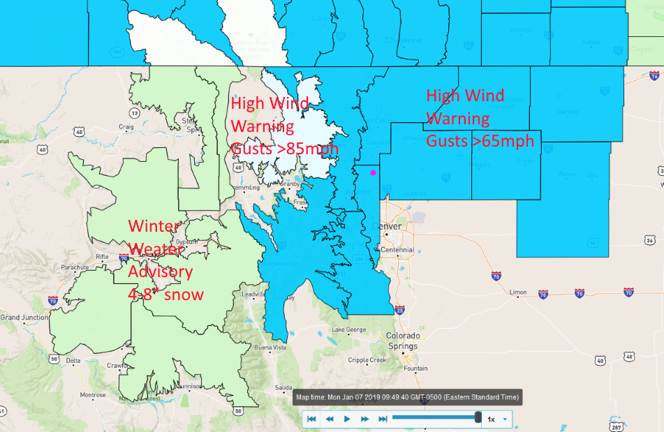
The high wind warnings have been expanded today.  Peak winds will occur between 11am and 4pm.  Channel 4 news predicted up to 100mph winds in the Foothills in wind prone areas.

Figure 1 update: current state weather warnings and advisories fro weatherunderground.com

End 8am Update.

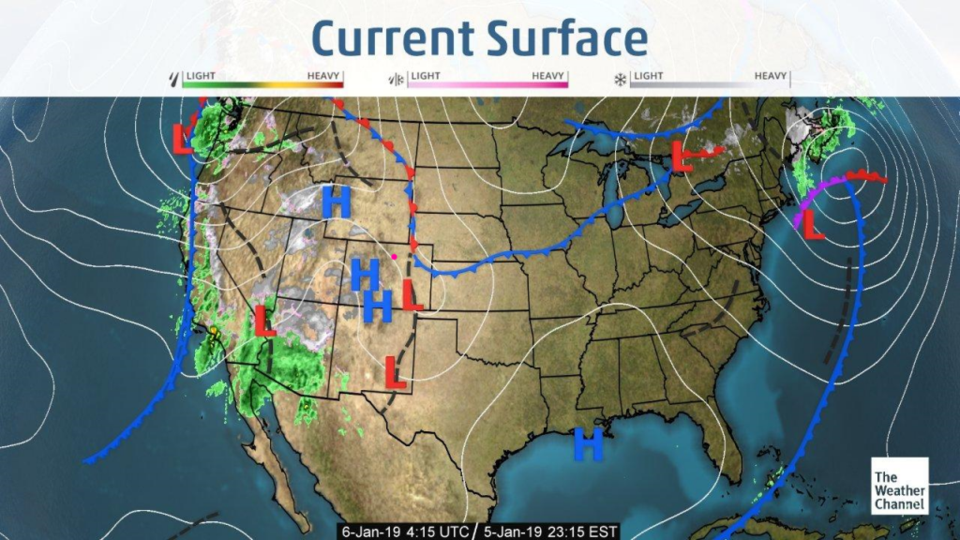
Super nice decoration-removing weather keeps on going.  I almost started on the front yard lights yesterday. There is a lee trough and some moisture moving in, leading to cloudy skies later in the day on Saturday (Figure 1).  There is a lot of rainfall and snowfall hitting the western U.S. and desert southwest.

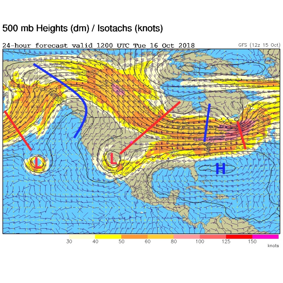
Later today, the trough creating all that unsettled weather moves towards us (red line in Figure 2 over Colorado), but the Rockies will wring out the moisture and we'll see nothing to nearly nothing but warm down slope flow.  A flurry or sprinkle might be possible to I-25 north of Denver tonight and tomorrow AM.  Don't count on it being much (Figure 3).

Figure 1: The current surface map from Saturday PM and the Weather Channel.

Figure 2: The 500mb forecast upper air analysis for Sunday PM. Pink dot is Longmont. Red lines are troughs, blue lines are ridges.

Figure 3: The forecast surface map for Sunday PM. From NCEP.

The longer range forecast:

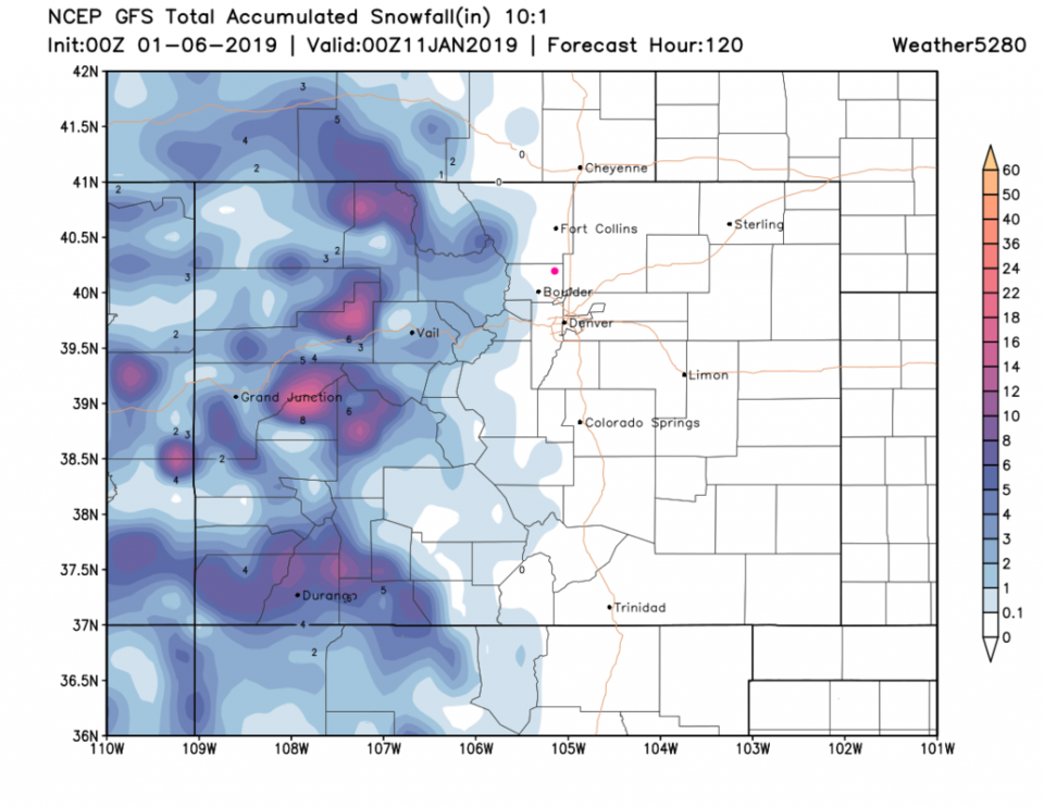
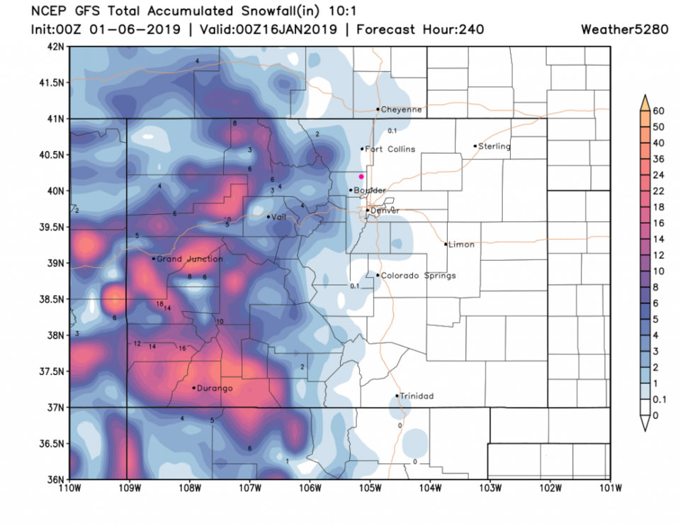
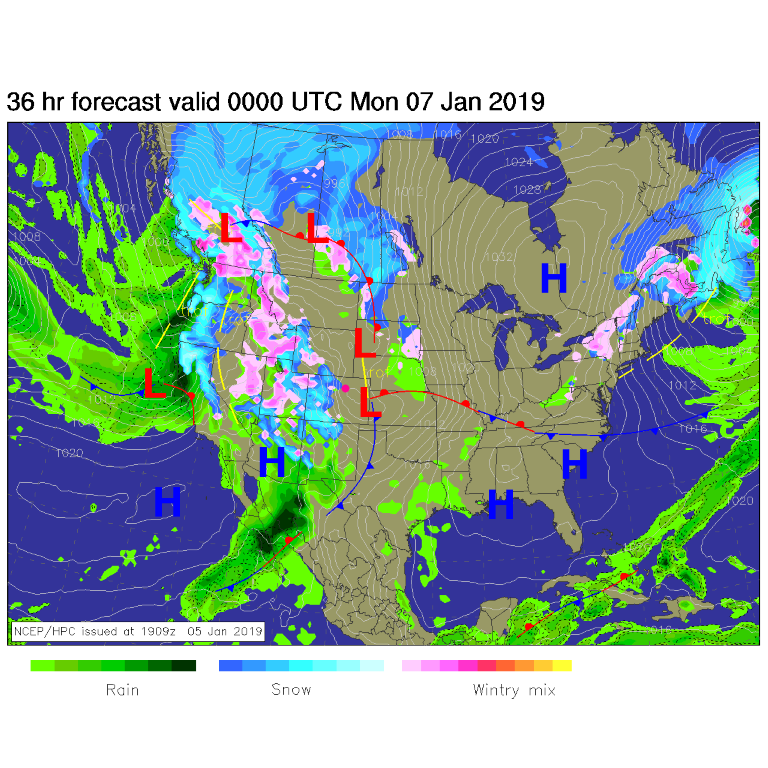
The snowfall for the next 5 days from the GFS shows up to a foot in places in the higher mountains (what a season it has been on THAT side of the Divide!!) - Figure 4. Even over the next 10 days, we'll be lucky to see an inch (according to this model - Figure 5).

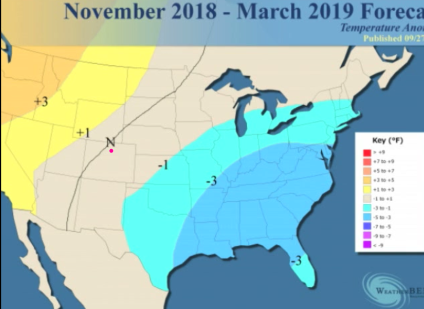
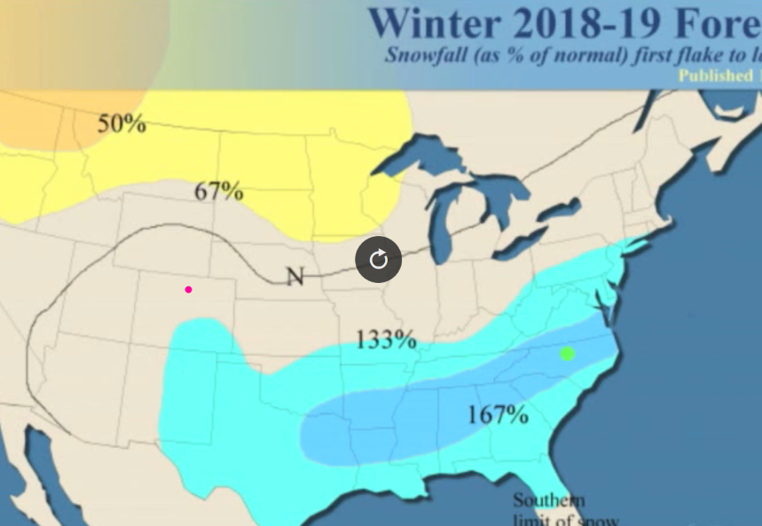
WeatherBell.com is still asserting its Winter forecast.  Figure 6 shows us just a bit below normal in temperatures. Figure 7 has us a bit above normal in snowfall.  A lot of catch-up needs to occur for this forecast to still come true.  We'll watch it here!

Figure 4: The forecast accumulated snow map from the GFS and weather5280.com for Colorado, for the next 5 days.

Figure 5: The forecast accumulated snow map from the GFS and weather5280.com for Colorado, for the next 10 days.

Figure 6: The Nov - March temperature forecast departure from normal from publicly released data from WeatherBell

Figure 7: The Nov - March snowfall forecast departure from normal from publicly released data from WeatherBell

Current Weather

Light rain

Light rain

36°F

UV Index
1 Low
Pressure
30.23 Rising
Visibility
8 miles
Dewpoint
33 °F
Humidity
88%
Wind
NNE 3.8 mph
Gust
6.5 mph
Wind Chill
34 °F

Hourly Forecast

Today
12 PM
38°F
Mostly cloudy
Today
1 PM
39°F
Intermittent clouds
Today
2 PM
40°F
Cloudy
Today
3 PM
41°F
Cloudy
Today
4 PM
42°F
Cloudy
Today
5 PM
40°F
Cloudy
Today
6 PM
39°F
Rain
Today
7 PM
38°F
Rain
Today
8 PM
37°F
Cloudy
Today
9 PM
35°F
Flurries
Today
10 PM
35°F
Cloudy
Today
11 PM
35°F
Rain and snow

7 Day Forecast

Rain and snow

Friday

42 °F

Cloudy and chilly; a couple of showers of rain or snow this morning followed by a little rain this afternoon


Rain and snow

Friday Night

32 °F

Periods of snow; rain mixed in early, accumulating 1-3 inches; roads could be slippery


Flurries

Saturday

39 °F

A bit of morning snow with little or no accumulation; otherwise, cloudy and chilly; storm total snowfall 1-3 inches


Intermittent clouds

Saturday Night

31 °F

A shower in places in the evening; otherwise, partly cloudy


Partly sunny

Sunday

64 °F

Partly sunny, pleasant and warmer


Mostly clear

Sunday Night

41 °F

Mainly clear


Intermittent clouds

Monday

79 °F

Warmer with a blend of sun and clouds


Partly cloudy

Monday Night

36 °F

Partly cloudy


Mostly cloudy

Tuesday

64 °F

Mostly cloudy and cooler


Mostly cloudy

Tuesday Night

40 °F

Mostly cloudy


Sunrise and Sunset

Sunrise
6:15 AM
Sunset
7:44 PM

Based on AccuWeather data