Skip to content

Next Storm/Next Snow Forecast Discussion from the Cherrywood Observatory – January 18, 2019

This content was originally published by the Longmont Observer and is licensed under a Creative Commons license.

Forecast Discussion:

The storm arrives Thursday pm and will be away in the evening Friday. I'll post this early (Thurs PM) since rain showers may start at any time this evening (there are show showers in Estes Park and echos around Lyons as of 7:30 pm).

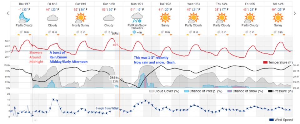
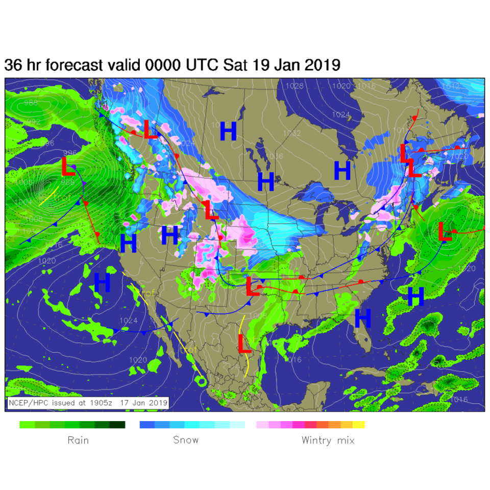
A front pushes down the Plains and only gets as far as the foothills of the Rockies - since cold air is dense and forms shallow layers often. We are on the coastline of a sea of increasingly cold air out East (Figure 1). As we see in Figure 6, there is an overnight period of showers and then a midday into afternoon period of rain and or show showers (we are right on the edge again as temperatures go).

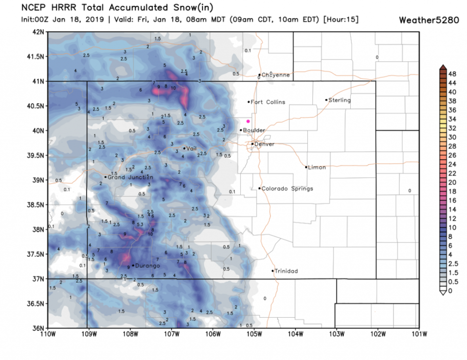
Figure 2 is the 15 hour forecast through 8 am Friday on the HRRR model. We don't get any snow by then, but Estes Park might see 2-3 inches.

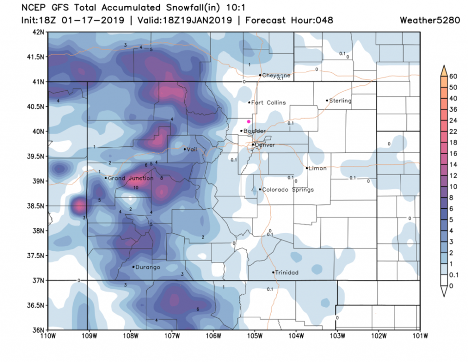
Figure 3 is the total snow through the weekend from the GFS - Longmont is in a dry hole, but there is snow around us (coating to 1 inch amounts).

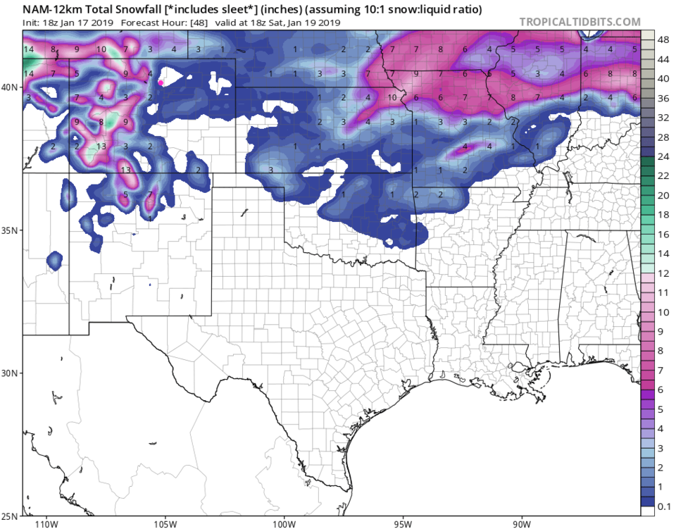
Figure 4 is the NAM for the same period. We are in a snow-free hole here too (so maybe a coating is possible?)

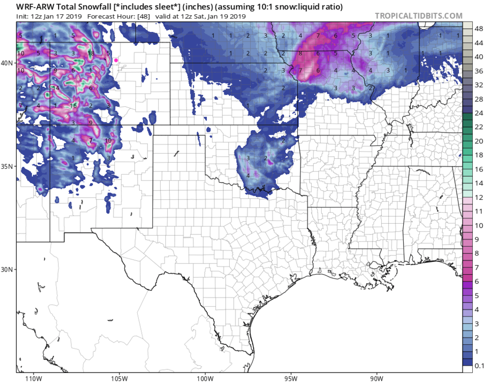
Figure 5 is the WRF and we are snow free here too.  :-(  I'd be happy with another 1/2 inch of rain for the plant life out there.

Figure 1: The forecast surface map for Friday PM. From NCEP.

Figure 2: The forecast accumulated snow map from the HRRR and weather5280.com for Colorado, for the next 15 hours - through 8 am Friday.

Figure 3: The forecast accumulated snow map from the GFS and weather5280.com for Colorado, for the next 48 hours through noon Saturday.

Figure 4: The forecast accumulated snow map from the NAM and tropicaltidbits.com for Colorado, for the next 48 hours through noon Saturday.

Figure 5: The forecast accumulated snow map from the WRF and tropicaltidbits.com for Colorado, for the next 48 hours through noon Saturday.

The longer range forecast:

We shoot back to the 50's F for the weekend then another storm will bring some moisture (I'm doubting snow, of course) Monday into Tuesday. We get colder and stay colder after that as an Arctic cold air mass takes over the Great Plains and Eastern states. They are going to REALLY feel winter starting next week.

Eclipse forecast Sunday 8:30- 11ish. :

We now have a 1% chance of precipitation. Skies partly cloudy (around 1/3rd covered by clouds). Temperatures at the start of the eclipse may be around 36°F dropping to 34°F by the end.

Figure 6: a snippet of the graphical forecast for the weekend forecast for Longmont, CO from weatherunderground.com

Current Weather

Clear

Clear

43°F

UV Index
0 Low
Pressure
30.11 Falling
Visibility
7 miles
Dewpoint
39 °F
Humidity
86%
Wind
NW 1.7 mph
Gust
3.3 mph
Wind Chill
43 °F

Hourly Forecast

Today
5 AM
41°F
Intermittent clouds
Today
6 AM
40°F
Intermittent clouds
Today
7 AM
43°F
Intermittent clouds
Today
8 AM
45°F
Mostly sunny
Today
9 AM
51°F
Mostly sunny
Today
10 AM
57°F
Mostly sunny
Today
11 AM
62°F
Mostly sunny
Today
12 PM
66°F
Mostly sunny
Today
1 PM
70°F
Mostly sunny
Today
2 PM
73°F
Mostly sunny
Today
3 PM
74°F
Mostly sunny
Today
4 PM
76°F
Mostly sunny

7 Day Forecast

Mostly sunny

Wednesday

76 °F

Pleasant and warmer with sunshine and patchy clouds


Partly cloudy

Wednesday Night

42 °F

Patchy clouds


Mostly cloudy w/ t-storms

Thursday

76 °F

Becoming cloudy; breezy in the afternoon with a thunderstorm in spots


Thunderstorms

Thursday Night

47 °F

A thunderstorm in spots in the evening; otherwise, considerable cloudiness


Showers

Friday

71 °F

Mostly cloudy with a couple of showers


Cloudy

Friday Night

46 °F

Cloudy


Showers

Saturday

53 °F

Cloudy and cooler with a couple of showers


Rain

Saturday Night

39 °F

Cloudy with steady rain becoming intermittent


Cloudy

Sunday

59 °F

Cloudy with a stray thundershower in the afternoon


Partly cloudy

Sunday Night

38 °F

Partly cloudy


Sunrise and Sunset

Sunrise
6:08 AM
Sunset
7:49 PM

Based on AccuWeather data