Skip to content

Next Storm/Next Snow Forecast Discussion from the Cherrywood Observatory – January 16, 2019

This content was originally published by the Longmont Observer and is licensed under a Creative Commons license.

Forecast Discussion:

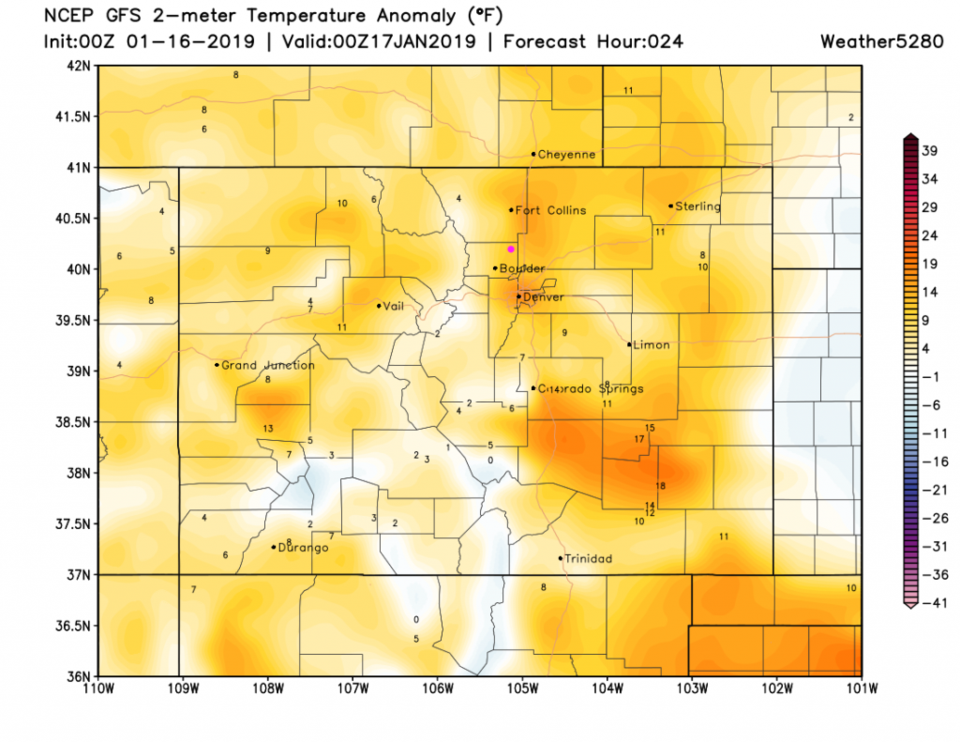
The big sloppy western storm system(s) are dumping their moisture in the western U.S states. Precipitation stops at the continental divide, for the most part (Figure 1). State temperatures are still above average this afternoon (Figure 2) with Longmont at about 8 F warmer than we'd expect for this date.

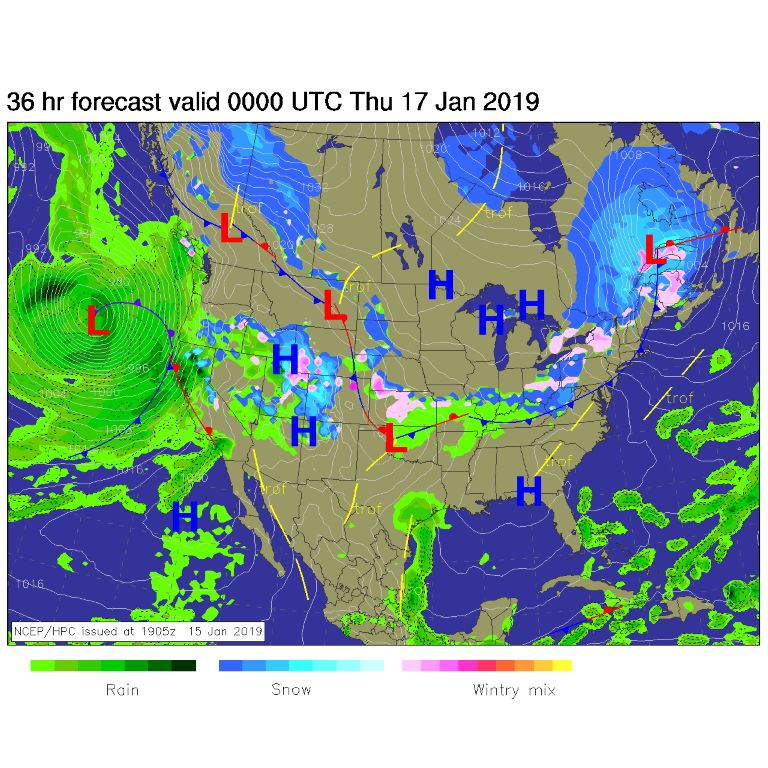
Figure 1: The forecast surface map for Wednesday PM. From NCEP.

Figure 2: The forecast temperature departure from normal from the GFS and weather5280.com for Colorado, for Wednesday PM.'

The longer range forecast:

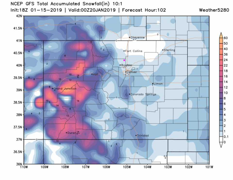
The mountains still get a lot of snow over the next 5 days while we 'may' get a coating to an inch of snow (though temperatures still look to warm to me - like last Friday - see Figure 5).  More later!

Eclipse Invitation:

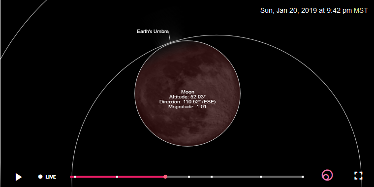
My readers are invited to the (yes it's real) Cherrywood Observatory to observe the total lunar eclipse Sunday evening January 20th.

The scopes will be set up at 8:30pm (the ‘dark bite’ begins 8:34p). Totality begins at 9:41pm. Sunlight begins to return on the limb of the moon at 10:43pm. The last of the ‘dark bite’ will leave at 11:51pm. I’ll keep the observatory open if people want to stay that long after totality begins. If it is cloudy or snowing, text or call to confirm that we’re still open. Contact me if you need the address (720-378-2771 - text your name and request).

(Figure 4.)

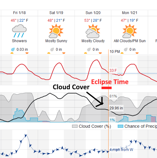
Weather for the eclipse: Partly to Mostly Cloudy skies are expected (80% cloudy at first then clearing some). There is a 4% chance of a shower. Temperatures will be around 31F at the start of eclipse dropping to 28F before midnight. (Figure 5)

Figure 3: The forecast accumulated snow map from the GFS and weather5280.com for Colorado, for the next 5 days through Sunday PM.

Figure 4: a graphical depiction of the beginning of totality over Denver from https://www.timeanddate.com/eclipse/in/usa/denver

Figure 5: a snippet of the graphical forecast for the weekend forecast for Longmont, CO from weatherunderground.com

Current Weather

Mostly cloudy

Mostly cloudy

69°F

UV Index
3 Moderate
Pressure
29.59 Steady
Visibility
8 miles
Dewpoint
31 °F
Humidity
25%
Wind
WNW 4.9 mph
Gust
10.5 mph
Wind Chill
69 °F

Hourly Forecast

Today
2 PM
69°F
Thunderstorms
Today
3 PM
70°F
Intermittent clouds
Today
4 PM
68°F
Intermittent clouds
Today
5 PM
66°F
Mostly cloudy
Today
6 PM
61°F
Thunderstorms
Today
7 PM
58°F
Thunderstorms
Today
8 PM
56°F
Cloudy
Today
9 PM
53°F
Cloudy
Today
10 PM
51°F
Thunderstorms
Today
11 PM
49°F
Thunderstorms
Tomorrow
12 AM
48°F
Cloudy
Tomorrow
1 AM
48°F
Cloudy

7 Day Forecast

Mostly cloudy w/ t-storms

Friday

70 °F

Variable cloudiness with a couple of thundershowers this afternoon; gusty winds and small hail can accompany any downpour


Thunderstorms

Friday Night

44 °F

Cloudy; a couple of showers and a thunderstorm this evening followed by periods of rain late; gusty winds and small hail can accompany any downpour


Rain

Saturday

47 °F

Chilly with periods of rain and a thunderstorm; travel in the foothills and mountains will be slippery due to snow


Rain and snow

Saturday Night

36 °F

Cloudy with rain, mixed with a little snow late; travel in the foothills and mountains will be slippery due to snow


Mostly cloudy

Sunday

61 °F

Mostly cloudy and warmer


Intermittent clouds

Sunday Night

36 °F

A thunderstorm in spots in the evening; otherwise, partly cloudy


Partly sunny

Monday

71 °F

Partly sunny, pleasant and warmer


Partly cloudy

Monday Night

45 °F

Partly cloudy


Mostly sunny

Tuesday

73 °F

Pleasant with sunshine and patchy clouds


Partly cloudy

Tuesday Night

43 °F

Partly cloudy


Sunrise and Sunset

Sunrise
6:06 AM
Sunset
7:51 PM

Based on AccuWeather data