Skip to content

Next Storm/Next Snow Forecast Discussion from the Cherrywood Observatory – January 15, 2019

This content was originally published by the Longmont Observer and is licensed under a Creative Commons license.

Forecast Discussion:

Not much has changed since the discussion yesterday. The two western lows (pink arrows) have moved closer to the state. The western slopes of Colorado will start to feel the storm effects (yes more snow) by tonight (Figure 1). We stay dry and abnormally warm on this side of the Divide.

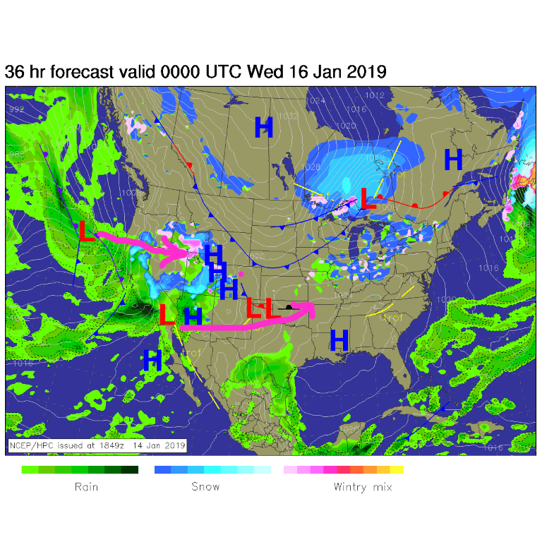
Figure 1: The forecast surface map for Tuesday PM. From NCEP. The longer range forecast:

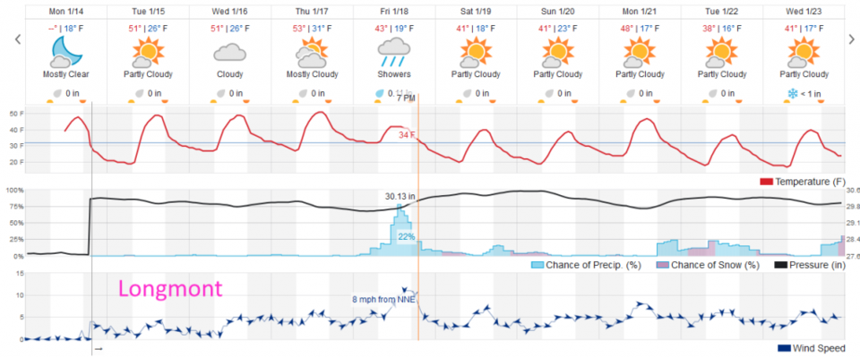
We don't see any storm effects until Friday (still) but temperatures are looking warmer during that storm than previously (forecasted by the weatherunderground model). Through the storm's precipitation event, temperatures are around 40° F again (very much like last Friday's - spooky similarity!). We may not see much snow, but just more rain (Figure 2).

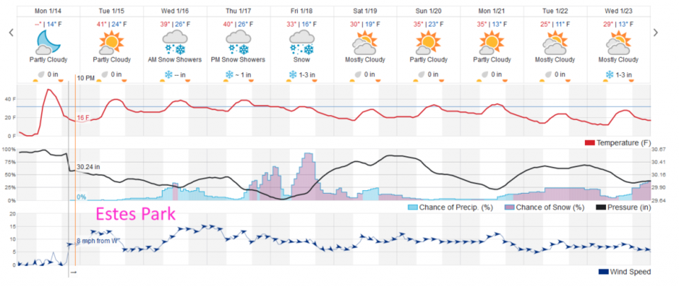
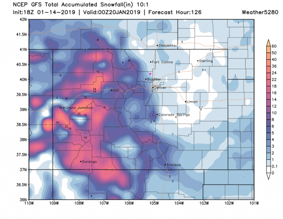
Estes Park and the mountains see more snow staring Wednesday and on through Saturday (at least at small chances - Figure 3). Snow isn't far away. The snowfall from the GFS over the next 5 days shows that the GFS thinks we are a bit colder and gives us 1/10th to 1 inch of snow by Saturday PM (Figure 4). The forecast will become more accurate in a day or two!

Figure 2: the graphical forecast for the next 10 days forecast for Longmont, CO from weatherunderground.com

Figure 3: the graphical forecast for the next 10 days forecast for Estes Park, CO from weatherunderground.com

Figure 4: The forecast accumulated snow map from the GFS and weather5280.com for Colorado, for the next 5 days through Saturday PM.

Current Weather

Cloudy

Cloudy

35°F

UV Index
0 Low
Pressure
30.25 Steady
Visibility
5 miles
Dewpoint
32 °F
Humidity
89%
Wind
E 1.1 mph
Gust
2.8 mph
Wind Chill
35 °F

Hourly Forecast

Today
2 AM
34°F
Showers
Today
3 AM
34°F
Cloudy
Today
4 AM
34°F
Mostly cloudy
Today
5 AM
34°F
Mostly cloudy
Today
6 AM
34°F
Cloudy
Today
7 AM
35°F
Cloudy
Today
8 AM
36°F
Intermittent clouds
Today
9 AM
37°F
Intermittent clouds
Today
10 AM
40°F
Intermittent clouds
Today
11 AM
43°F
Intermittent clouds
Today
12 PM
46°F
Intermittent clouds
Today
1 PM
46°F
Intermittent clouds

7 Day Forecast

Rain and snow

Thursday

37 °F

Cloudy and much colder; snow showers this morning, accumulating a coating to an inch followed by brief showers this afternoon


Showers

Thursday Night

34 °F

Mostly cloudy with a couple of brief showers beginning late evening


Mostly cloudy w/ showers

Friday

47 °F

Chilly with some sun, then turning cloudy; a little rain in the afternoon


Rain and snow

Friday Night

33 °F

Periods of snow; rain mixed in early, accumulating an inch or two


Flurries

Saturday

43 °F

A bit of morning snow with little or no accumulation; otherwise, cloudy and chilly; storm total snowfall an inch or two


Intermittent clouds

Saturday Night

31 °F

Partly cloudy


Partly sunny

Sunday

69 °F

Pleasant and warmer with partial sunshine


Partly cloudy

Sunday Night

44 °F

Partly cloudy


Intermittent clouds

Monday

79 °F

Very warm with a blend of sun and clouds


Intermittent clouds

Monday Night

36 °F

Increasing clouds


Sunrise and Sunset

Sunrise
6:17 AM
Sunset
7:43 PM

Based on AccuWeather data