Skip to content

Next Storm/Next Snow Forecast Discussion from the Cherrywood Observatory – January 13, 2019

This content was originally published by the Longmont Observer and is licensed under a Creative Commons license.

Forecast Discussion:

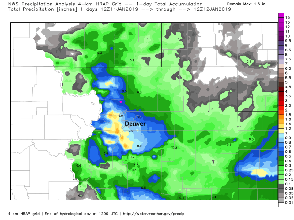
To follow up with my spot-reporting from CoCoRaHS in the update yesterday, the NWS analysis for water content accumulation with this storm is in Figure 1. There are impressive amounts topping an inch of liquid west and south of Denver and up around RMNP. That is a wonderful shot in the arm. I'm sad the western and southwestern slopes didn't get anything.

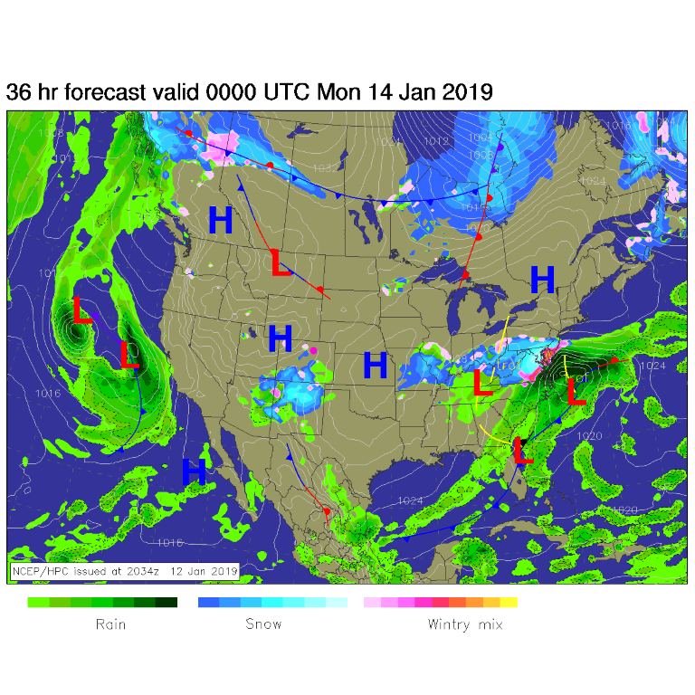
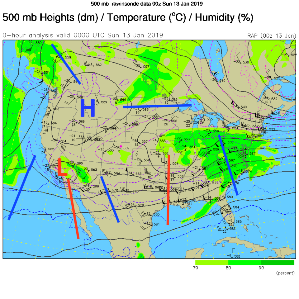
We do have another storm passing to the south of us Saturday PM into Sunday (Figure 2) which will bring some moisture in down there. The upper air pattern shows a big high pressure center over the western states (Figure 3). That system's low center is way down in the southern California/Arizona area.

Figure 1: NWS Precipitation analysis posted by weather5280.com for Friday liquid accumulation.

Figure 2: The forecast surface map for Sunday PM. From NCEP.

Figure 3: NCEP 500 mb upper air map from Saturday PM. Blue lines are ridges, red lines are troughs.

The longer range forecast:

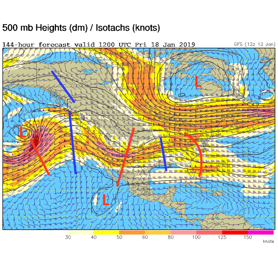
The next storm on the horizon comes late Thursday PM into Friday. The upper air pattern shows a trough in the southern branch passing right overhead Friday AM (Figure 4). The long range forecast shows temperatures right around 50° F all week (under that ridge) with Friday cooling only to around 40° F and dropping later in that storm Friday PM (as the trough arrives). Go do your snow-dance now.

Figure 4: The 500mb forecast upper air analysis for Friday AM. Pink dot is Longmont. Red lines are troughs, blue lines are ridges.

Figure 5: the graphical forecast for the next 10 days forecast for Longmont, CO from weatherunderground.com

Current Weather

Mostly cloudy

Mostly cloudy

50°F

UV Index
0 Low
Pressure
29.92 Falling
Visibility
7 miles
Dewpoint
44 °F
Humidity
80%
Wind
NNW 2.8 mph
Gust
6.2 mph
Wind Chill
50 °F

Hourly Forecast

Today
4 AM
46°F
Clear
Today
5 AM
43°F
Mostly clear
Today
6 AM
41°F
Mostly clear
Today
7 AM
45°F
Partly sunny
Today
8 AM
52°F
Partly sunny
Today
9 AM
59°F
Partly sunny
Today
10 AM
65°F
Intermittent clouds
Today
11 AM
71°F
Intermittent clouds
Today
12 PM
75°F
Intermittent clouds
Today
1 PM
77°F
Intermittent clouds
Today
2 PM
75°F
Thunderstorms
Today
3 PM
73°F
Cloudy

7 Day Forecast

Mostly sunny

Wednesday

75 °F

Mostly sunny, pleasant and warmer


Partly cloudy

Wednesday Night

41 °F

Patchy clouds


Mostly cloudy w/ t-storms

Thursday

77 °F

Turning cloudy, warm; breezy, a stray thunderstorm this afternoon


Thunderstorms

Thursday Night

47 °F

A thunderstorm in spots this evening; otherwise, considerable cloudiness


Thunderstorms

Friday

69 °F

Mostly cloudy and not as warm with a couple of thundershowers


Thunderstorms

Friday Night

44 °F

Cloudy with a couple of thundershowers


Rain

Saturday

46 °F

Chilly with periods of rain and a thunderstorm


Rain and snow

Saturday Night

39 °F

Cloudy with rain, mixed with a little snow late


Mostly cloudy

Sunday

59 °F

Mostly cloudy and warmer; a stray afternoon thundershower


Partly cloudy

Sunday Night

36 °F

Partly cloudy


Sunrise and Sunset

Sunrise
6:08 AM
Sunset
7:49 PM

Based on AccuWeather data