This content was originally published by the Longmont Observer and is licensed under a Creative Commons license.
Forecast Discussion:
11am Update (snow reports):
The forecast came out pretty well. (The models below showing additional snow amounts was overdone though... they got too excited about the evening snow event.)
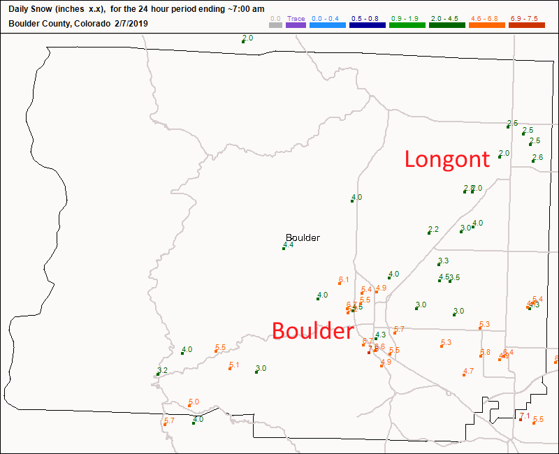
Longmont saw about 2.5 inches of snow while Boulder saw 5-6 inches. (Figure 1 update.)
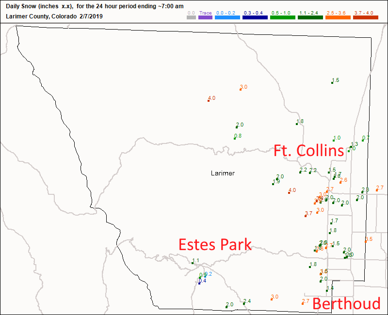
Ft Collins got 1.5 to 3 inches of snow while Estes park got up to an inch. Berthoud saw about 2 inches (Figure 2 update).
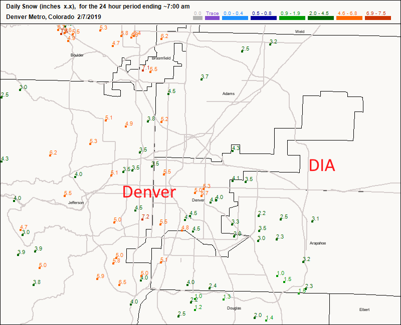
Denver saw 5 inches on the western side and about 2-4 inches on the eastern side (Figure 3 update).
My house dropped to -4F in my backyard thermometer. Brrrr.
Figure 1 update: new Snow totals for Wednesday up to 7am Thursday for Boulder county from CoCoRaHS.
Figure 2 update: new Snow totals for Wednesday up to 7am Thursday for Larimer county from CoCoRaHS.
Figure 3 update: new Snow totals for Wednesday up to 7am Thursday for the Denver metro from CoCoRaHS.
End 11am Update.
We are still under an advisory through 5 am Thursday:
Winter Weather Advisory issued February 6 at 9:17AM MST
expiring February 7 at 5:00AM MST by NWS Denver CO
A WINTERY MIX FOR NORTHERN COLORADO TODAY. Areas of dense fog, freezing drizzle and flurries over the plains this morning will transition to all snow by this afternoon while snow will continue over the mountains. Snow will gradually diminish from west to east later tonight. Isolated areas of roads may already be icy across the plains, especially over bridges. Then roads across the rest of the area will likely become icy and snowpacked by mid afternoon and into the evening resulting in difficult travel over both the mountains and plains.
* WHAT...Expect dense fog down to a quarter of a mile, areas of freezing drizzle and snow this morning, transitioning to all snow this afternoon. Additional snow accumulations of 2 to 5 inches. Cold windchill readings as low as 25 below overnight.
* WHERE...The foothills, urban corridor and plains of north central and northeast Colorado. * WHEN...Until 5 AM MST Thursday.
* ADDITIONAL DETAILS...Plan on slippery road conditions as early as this morning. Conditions will become more hazardous throughout the day to impact the evening commute. The cold wind chills as low as 25 below zero could cause frostbite on exposed skin in as little as 30 minutes.
______________________________
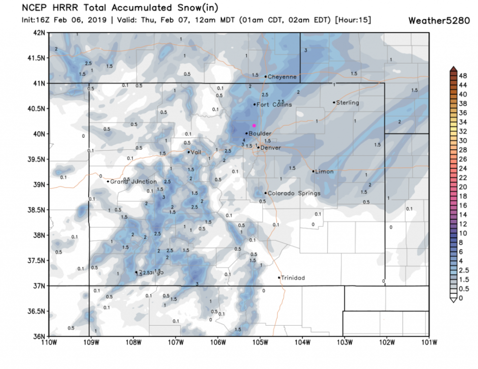
We are mid-storm, so I'll post Thursday's forecast a bit early, then update with snow totals in the afternoon (reports start coming in at 7 am). The HRRR (high resolution model) still has a snow band over Boulder (Figure 1). Amazingly, it has 3-4 inches yet to fall between 10 am and midnight going into Thursday. The GFS still has 2-3 inches yet to fall. We'll see!
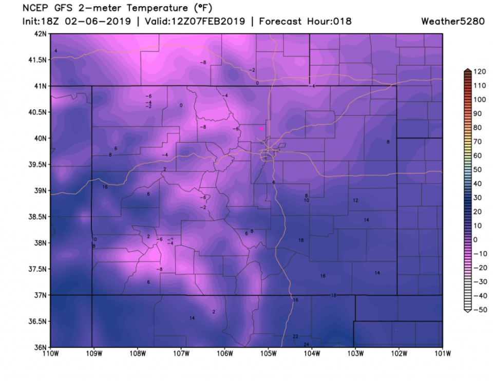
Our earlier snow band gave us 2 inches in my yard. The temperatures after 3:30 pm have already dropped into the upper teens. The forecast low from the GFS at 6 am is really close to 0°F (Figure 3). With some wind, the wind chill temperature will be below zero and dangerous.
The longer range forecast:
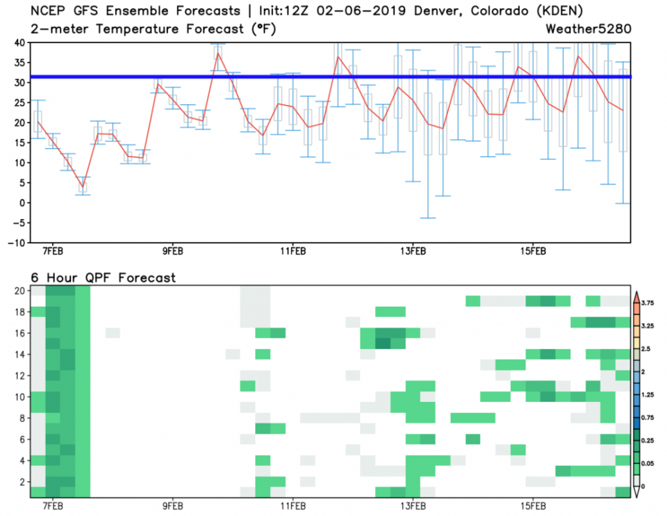
We stay below or near freezing much of the next 10 days (from the GFS - Figure 4). Our precipitation tonight seems pretty certain (that is where the 2-3 inches must come from). There are snow events possible every other day, but they are not across-the-board certain any given day. We'll watch that once this system is past.
Figure 1: the forecast accumulated snow map from the HRRR and weather5280.com for Colorado, through Thursday midnight.
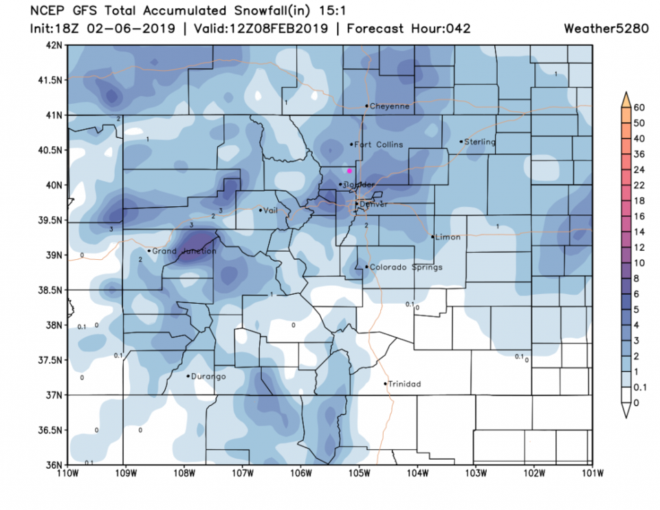
Figure 2: the forecast accumulated snow map from the GFS and weather5280.com for Colorado, through Friday early morning. With colder air in place, going with 15:1 snow /water radio. (Normally 10:1 is assumed.)
Figure 3: The actual surface temperature at 6am Thursday across Colorado from the GFS and weather5280.com
Figure 4: 10 day meteogram from weather5280.com for DIA.