This content was originally published by the Longmont Observer and is licensed under a Creative Commons license.
In Brief:
Northwest flow aloft will bring in a LOT of moisture and snow to the northern and central Colorado mountains through the weekend. The drive up there Friday will be ROUGH! On the Plains, a widespread 3-6 inches of snow is expected with jet-stream created banding taking snow totals up to 10"+ for some locations. An overall change in the jet stream pattern will bring on and off snow events for the next 10 days. Temperatures will continue to drop overall through the next 10 days.
Update 2/7 8:30am and 10:30am (adding the advisory text):
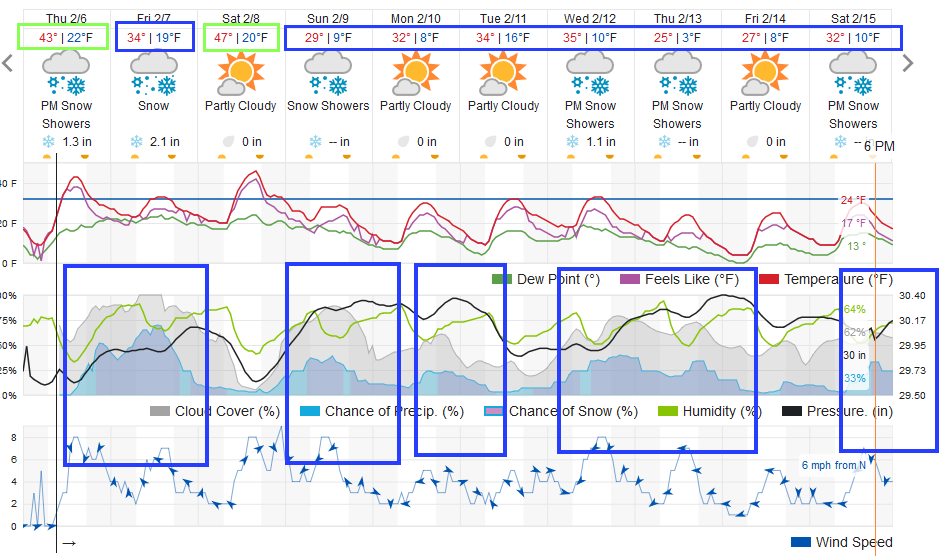
My front yard in NE Longmont received 2 inches overnight. The snow has begun to pick up again with a band of snow just north of town that may drift down to give us enhanced snowfall midday. I've shoveled once... I'll be doing THAT again! The snow chances remain high until about 8pm tonight (Figure 1 update).
We still have another shot of snow coming Sunday morning into early evening (probably under an inch) and again Monday night (also under an inch). This is an active, moist, pattern again!
The winter weather advisory has been extended to midnight tonigh:
Winter Weather Advisory Issued: 11:12 AM Feb. 7, 2020 – National Weather Service
...WINTER WEATHER ADVISORY REMAINS IN EFFECT UNTIL MIDNIGHT MST
TONIGHT...

* WHAT...Snow with banded snow. Additional snow accumulations of 3
to 6 inches, with up to 8 inches under heavier bands.

* WHERE...Portions of east central, north central and northeast
Colorado.

* WHEN...Until midnight MST tonight.

* IMPACTS...Plan on slippery road conditions. The hazardous
conditions could impact the evening commute. Visibility can
drastically drop under a heavier band,

PRECAUTIONARY/PREPAREDNESS ACTIONS...

Slow down and use caution while traveling.

The latest road conditions for the state you are calling from can
be obtained by calling 5 1 1.
End 2/7 8:30am update.
Forecast Discussion:
Let's start with the National Weather Service first:
Winter Weather AdvisoryIssued: 5:15 AM Feb. 6, 2020 – National Weather Service
...WINTER WEATHER ADVISORY IN EFFECT FROM 6 PM THIS EVENING TO
MIDNIGHT MST FRIDAY NIGHT...  Figure 1

* WHAT...Snow expected. Total snow accumulations of 3 to 6 inches.
Localized amounts up to 10 inches possible.

* WHERE...Portions of east central, north central and northeast
Colorado.

* WHEN...From 6 PM this evening to midnight MST Friday night.

* IMPACTS...Plan on slippery road conditions. The hazardous
conditions could impact the morning or evening commute.

PRECAUTIONARY/PREPAREDNESS ACTIONS...

Slow down and use caution while traveling.

The latest road conditions for the state you are calling from can
be obtained by calling 5 1 1.
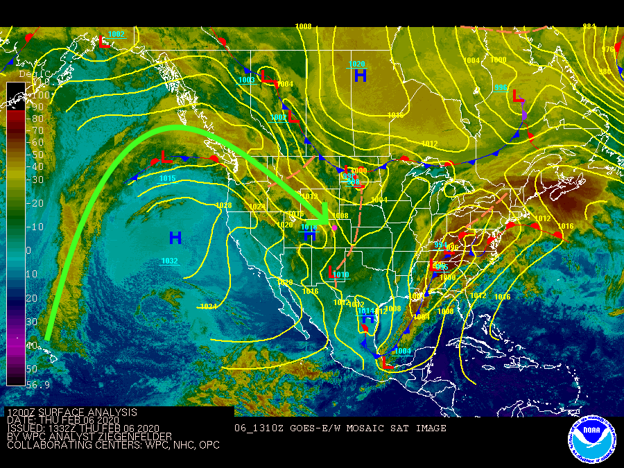
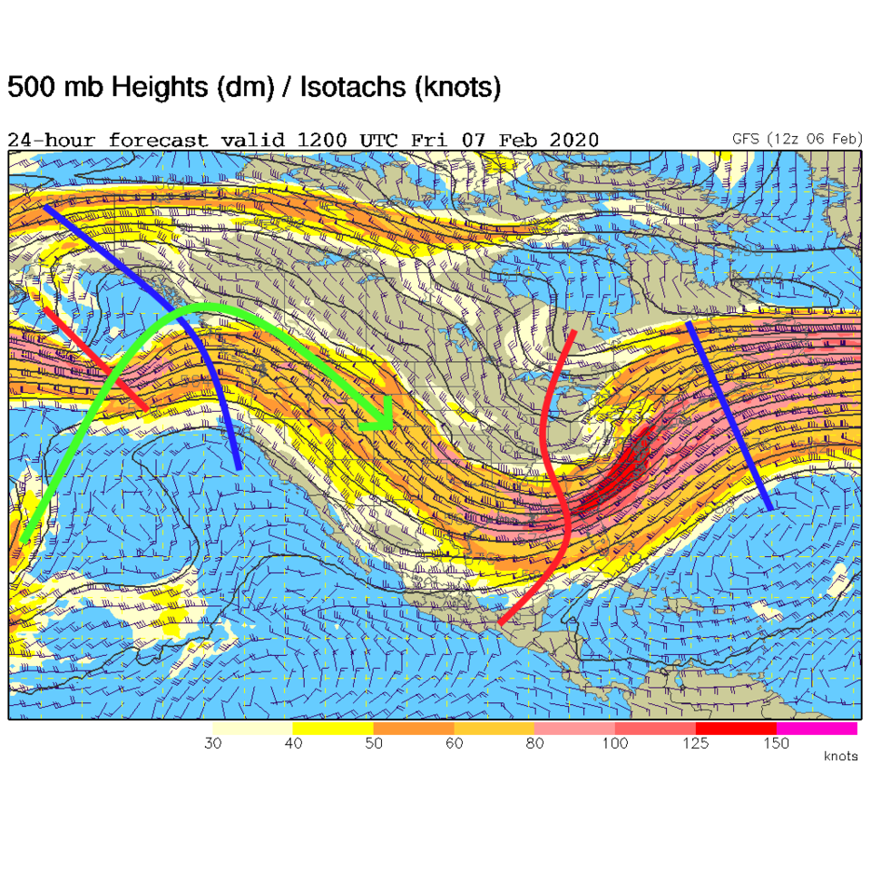
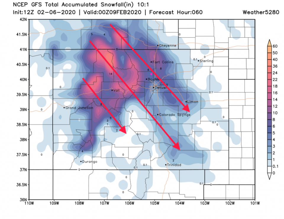
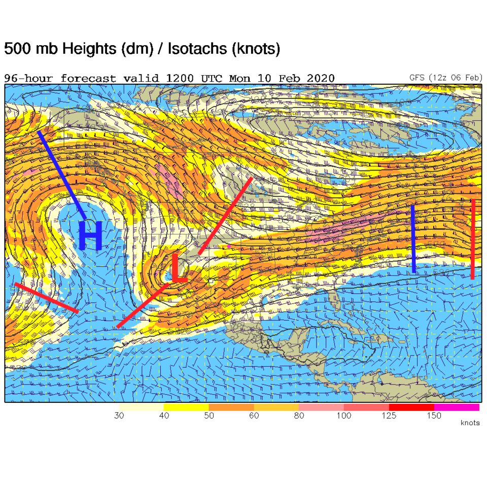
A giant high pressure center at the surface (and a ridge aloft) is routing tropical moisture up and over its top, through Canada, then right towards Colorado (green line Figure 2). You can see the ridge as the blue line in figure 3 - and the strong jet stream flow stretched northwest to southeast over Colorado. This moisture will dump 1-2 feet of snow on the mountains to our west over the next 48 hours. Some of that snow - created by the jet stream lift - will pour out onto the Plains (Figure 4).
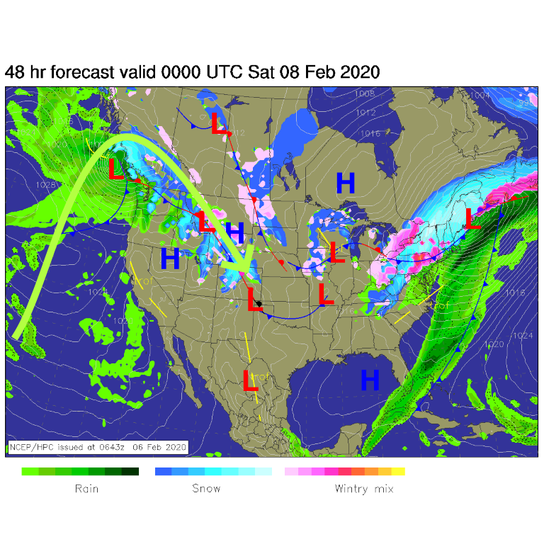
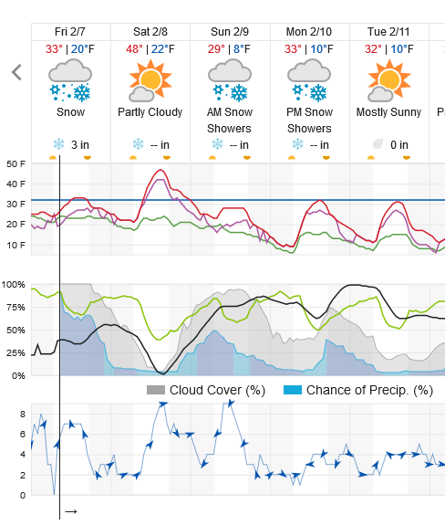
The snow should begin around 7pm Thursday and last until 5-7pm Friday (Figure 5). The heaviest snow should be overnight and pre-dawn Friday. It will be a rough commute Friday AM especially north of Denver.
Programming Note: If you wish to see this forecast discussion in video format - take a look at the Longmont Public Media YouTube video in Figure 10.
Snowfall Roundup:
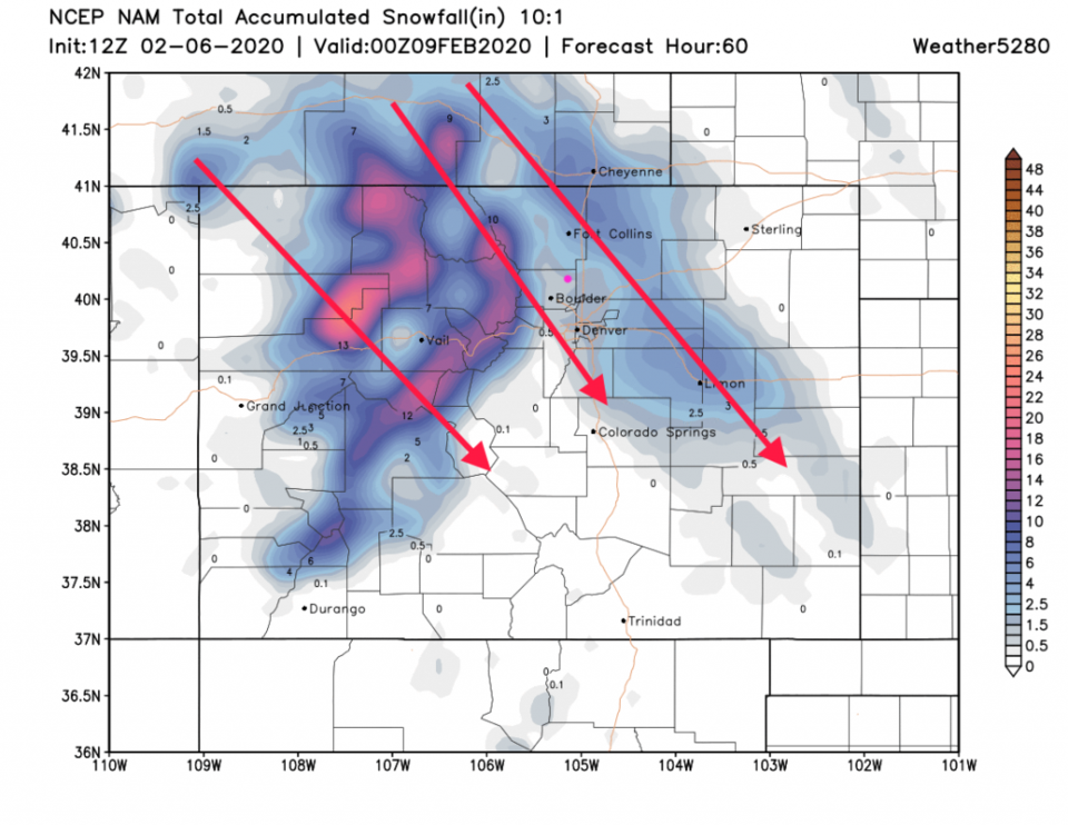
The jet stream will cause banding (lanes of enhanced snowfall) down the flow of the upper level winds (NW to SE). I've added red arrows to where the models "think" those bands will set up (on these runs). They may appear anywhere north or south of these positions. The snowfall under these bands could be double the average amount of snow to hit the region.
The GFS gives us 4-5 inches (Figure 6).
The NAM (seeing more down slope flow and less jet stream forcing) gives us 1/2 to 2 inches (Figure 7).
The GEM (not shown) gives us 3-5 inches.
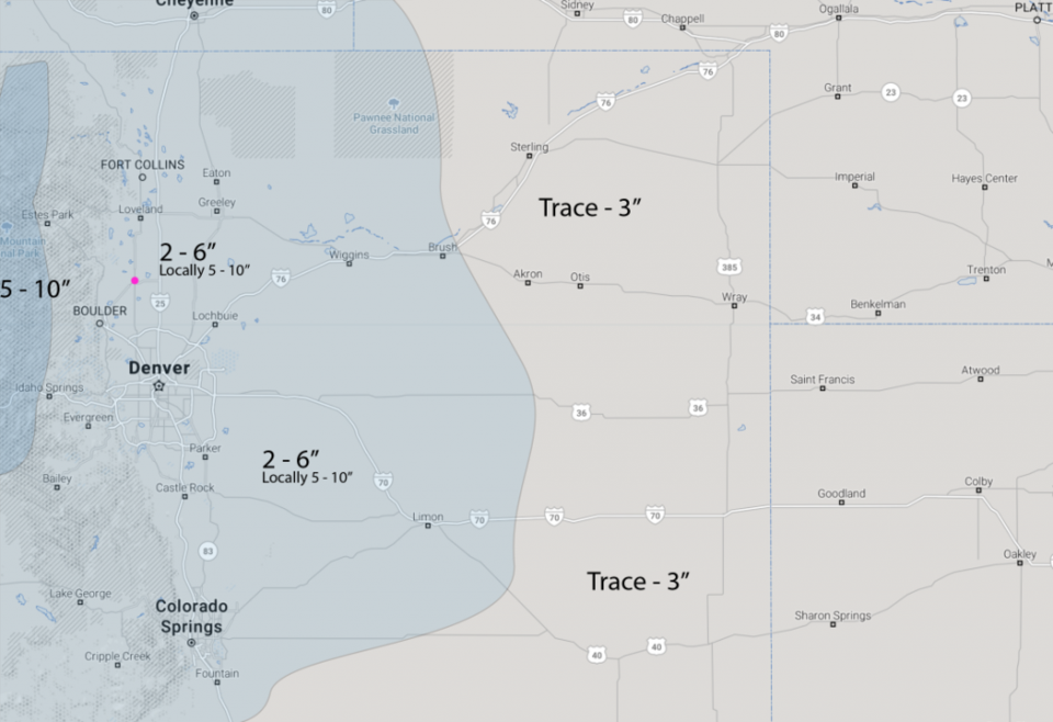
The weather5280 forecasters paint us with the 2-6 inch snowfall amounts (noting a possible 5-10 inches locally - Figure 8).
I'm calling for 3-6 inches for our town - noting that IF a band sets up overhead - we'll see more than the last storm (that ended with about 5 inches across town).
The Longer Range Forecast:
The pattern is changing with northwest flow and short wave troughs moving through our part of the nation for at least the next 10 days. This gives us a chance of snow Sunday (maybe about 1 inch - see the big trough in Figure 9), Monday (maybe a coating), Wednesday/Thursday (maybe 1-3 inches) and even far off over the next weekend (Figure 4). Note that temperatures will be dropping (overall) throughout this period. We are having winter now.