Skip to content

Next Storm/Next Snow Forecast Discussion from the Cherrywood Observatory – February 4, 2019

This content was originally published by the Longmont Observer and is licensed under a Creative Commons license.

Forecast Discussion:

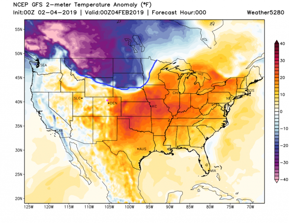
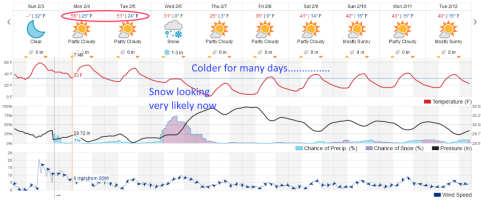
Closer the cold comes, step by step by step. Sunday PM, the leading edge of the very cold air has made it into Wyoming and the Dakotas (those poor people - Figure 1). We will see the typical pre-storm warmth with westerly down-slope winds (gusty at times) and compression heating. The cold air begins to slide in later Tuesday with almost 24 hours of snow on Wednesday (Figure 2).

The longer range forecast:

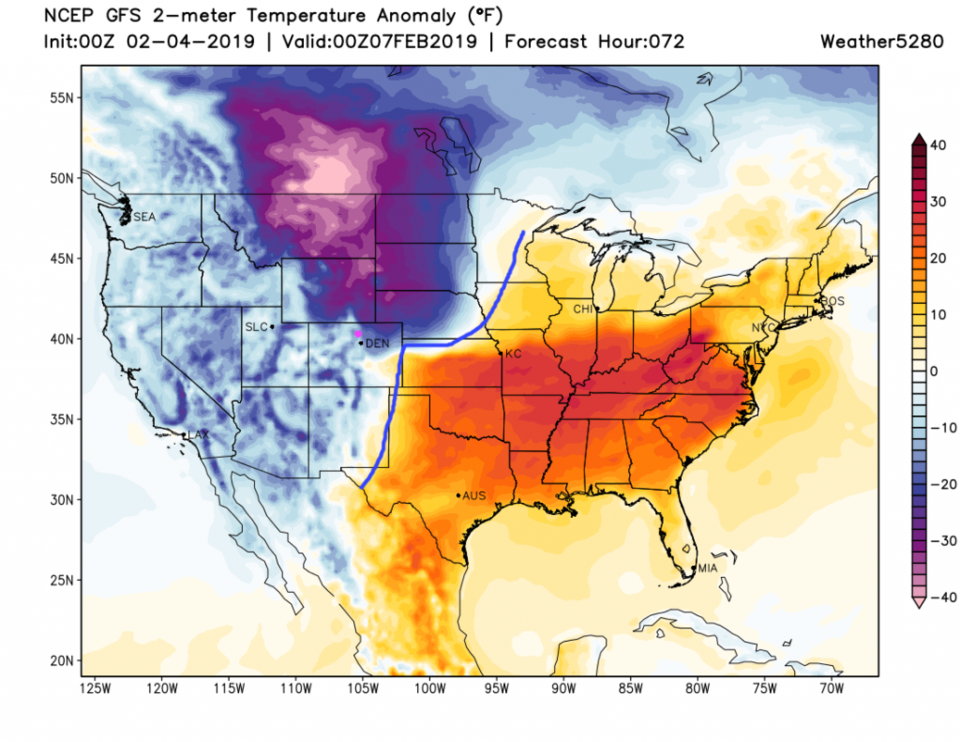
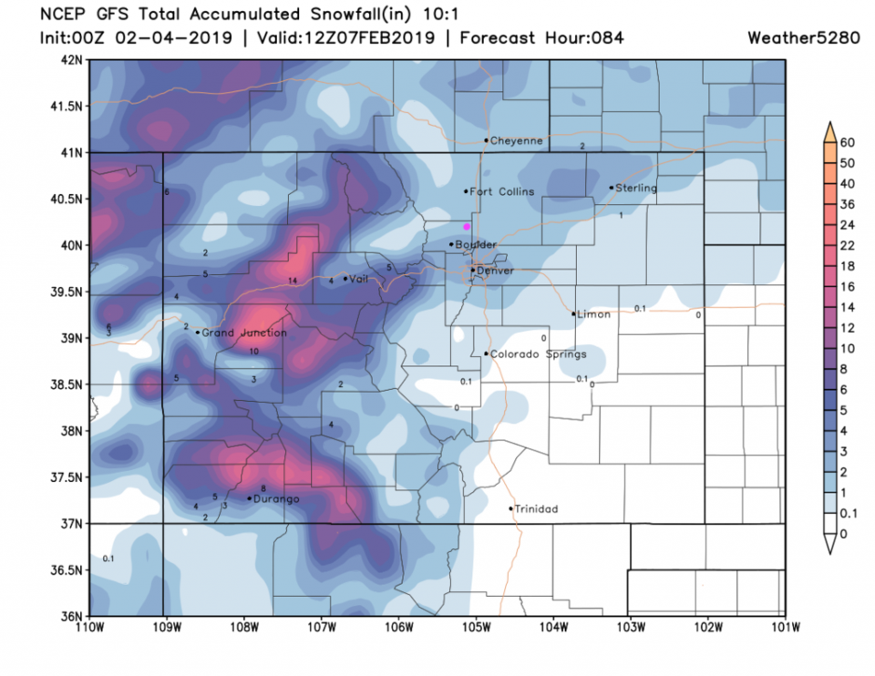
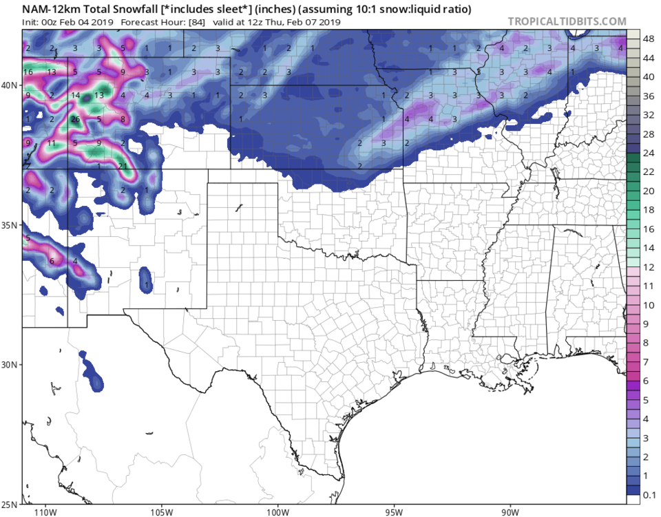
By Wednesday (Figure 3) air that is around 25°F below normal is sliding into Denver. This will feel like quite a shock after our mild week. The weatherunderground model has 1-3 inches of snowfall. The GFS model (Figure 4) gives us 1-2 inches. The NAM has us at about 2-3 inches (though it is hard to read in Figure 5). Those are too far off of most of this winter's storms and all models agree that a trough takes over for the ridge in the west and we stay below normal to normal, temperature-wise, for the rest of the 10 day window.  Yes, get the coats ready again.

Figure 1: The forecast temperature departure from normal map from the GFS and weather5280.com for Colorado, Sunday evening.

Figure 2: the graphical forecast for the next 10 days for Longmont, CO from weatherunderground.com

Figure 3: The forecast temperature departure from normal map from the GFS and weather5280.com for Colorado, Wednesday evening.

Figure 4: the forecast accumulated snow map from the GFS and weather5280.com for Colorado, through Thursday AM.

Figure 5: The forecast accumulated snow map from the NAM and tropicaltidbits.com for Colorado, through Thursday morning.

Current Weather

Light rain

Light rain

36°F

UV Index
1 Low
Pressure
30.23 Rising
Visibility
8 miles
Dewpoint
33 °F
Humidity
88%
Wind
NNE 3.8 mph
Gust
6.5 mph
Wind Chill
34 °F

Hourly Forecast

Today
12 PM
38°F
Mostly cloudy
Today
1 PM
39°F
Intermittent clouds
Today
2 PM
40°F
Cloudy
Today
3 PM
41°F
Cloudy
Today
4 PM
42°F
Cloudy
Today
5 PM
40°F
Cloudy
Today
6 PM
39°F
Rain
Today
7 PM
38°F
Rain
Today
8 PM
37°F
Cloudy
Today
9 PM
35°F
Flurries
Today
10 PM
35°F
Cloudy
Today
11 PM
35°F
Rain and snow

7 Day Forecast

Rain and snow

Friday

42 °F

Cloudy and chilly; a couple of showers of rain or snow this morning followed by a little rain this afternoon


Rain and snow

Friday Night

32 °F

Periods of snow; rain mixed in early, accumulating 1-3 inches; roads could be slippery


Flurries

Saturday

39 °F

A bit of morning snow with little or no accumulation; otherwise, cloudy and chilly; storm total snowfall 1-3 inches


Intermittent clouds

Saturday Night

31 °F

A shower in places in the evening; otherwise, partly cloudy


Partly sunny

Sunday

64 °F

Partly sunny, pleasant and warmer


Mostly clear

Sunday Night

41 °F

Mainly clear


Intermittent clouds

Monday

79 °F

Warmer with a blend of sun and clouds


Partly cloudy

Monday Night

36 °F

Partly cloudy


Mostly cloudy

Tuesday

64 °F

Mostly cloudy and cooler


Mostly cloudy

Tuesday Night

40 °F

Mostly cloudy


Sunrise and Sunset

Sunrise
6:15 AM
Sunset
7:44 PM

Based on AccuWeather data