Skip to content

Update 2/16 9pm: Next Storm/Next Snow Forecast Discussion from the Cherrywood Observatory – February 14-16, 2020

This content was originally published by the Longmont Observer and is licensed under a Creative Commons license.

In Brief:

With hit after hit of snow past us now, we have a quiet and warm (overall) weekend ahead of us. Our next stormy period runs from Monday morning to Wednesday morning when we may pick up an couple inches or a bit more of snow. Then we return to quiet conditions again beyond that!

Update 2/16 9pm:

The chilly weather returns as does more moisture. This doesn't look like a LOT of snow coming, but some rain showers early Monday will change to snow later on. Accumulations of 1-2 inches is most likely in town with a possible 2-3 inches nearby to the west. Things will remain unsettled Monday morning through late Wednesday night. There are a couple of better snow chances in the blue box time frames in Figure 2 update. The GFS still gives us only a coating to 1 inch across town (Figure 3 update). More to come tomorrow!
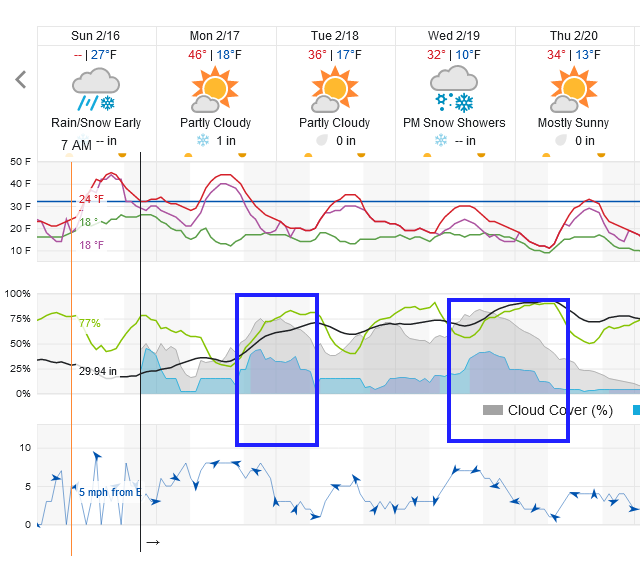
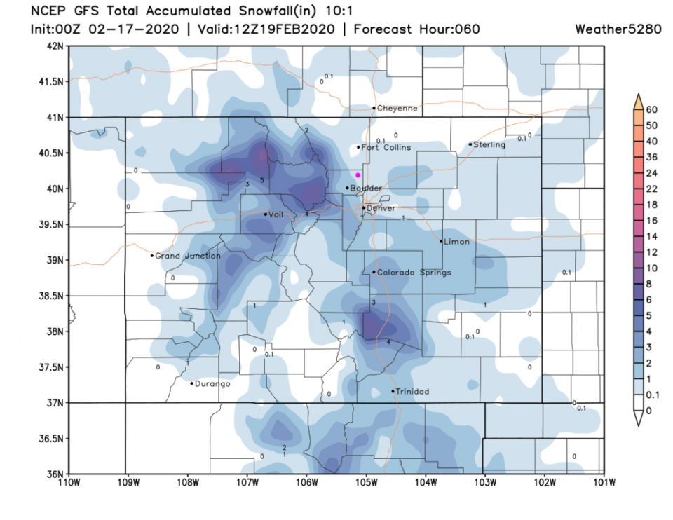
Figure 2 update: the snippet of the graphical forecast for the next 10 days for Longmont, CO from weatherunderground.com
Figure 3: 10:1 (snow to liquid) snowfall totals through Thursday morning from the GFS and weather5280com for Colorado made Monday afternoon.

End update 2/16 9pm.

Update 2/15 5pm:

We are still on track for temperatures around 50F for Sunday and 2-3 inches of snow for Monday/Tuesday. I'm posting the weekend video forecast discussion in Figure 1 update.

End update 2/15 5pm.

Forecast Discussion:

A warm front drifts past us on Friday taking us back to the 50'sF (Figure 1). Watch out for falling icicles. This warm up is brought on by more westerly air flow across the state giving us some down slope warming. There are shallow ridges (and a trough for Saturday) that will also help with the warming (Figure 2).

Oh, and Happy Valentines Day! (I almost forgot!)

The Longer Range Forecast:

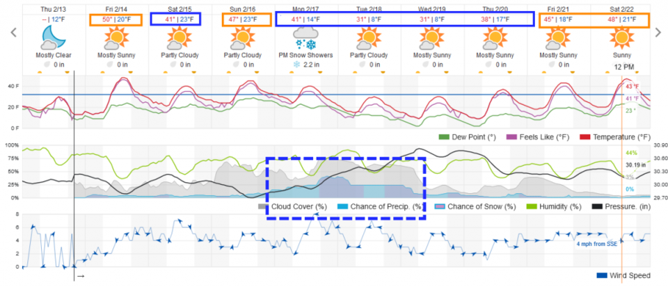
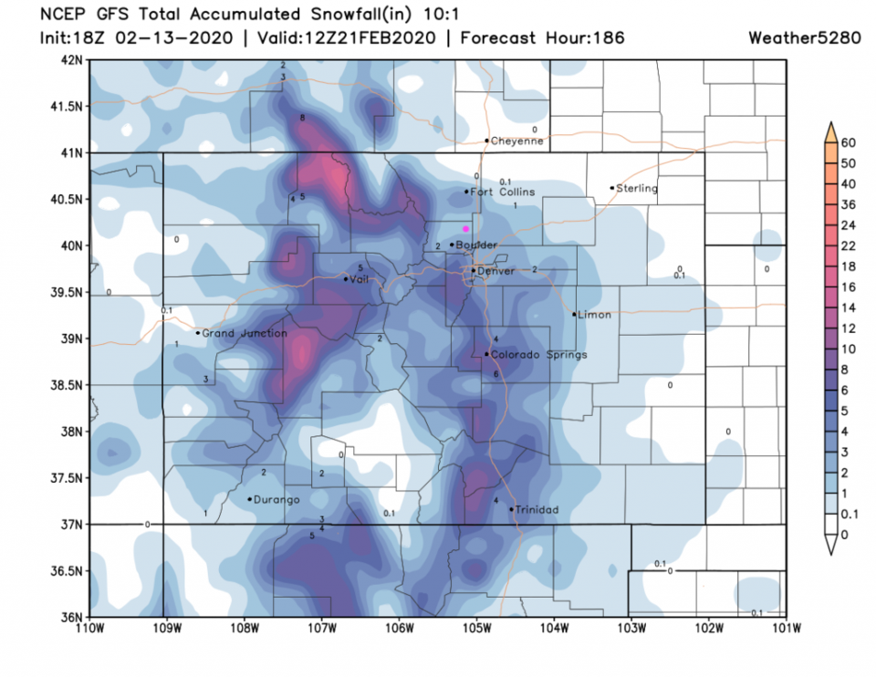
Our next storm doesn't roll in until very early Monday (Figure 3). Hurray, another potentially icy Monday commute. Right now it looks like 2-3 inches spread out over 2 1/2 days. Temperatures will be above normal Friday and Sunday and below normal Saturday then Monday through Thursday (blue and orange boxes). The GFS (Figure 4) gives us about 1-2 inches from this storm, but SW Denver and the foothills down I-25 to the south may see up to 10 inches in places. The mountains- again- get another foot or more in spots.

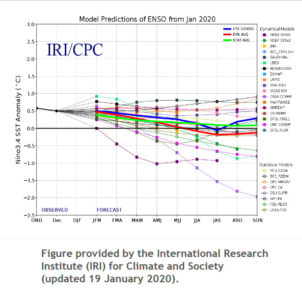
Just for fun, I thought we'd check in on the state of El Nino (or ENSO - El Nino Southern Oscillation - Figure 5). The ENSO index is trending towards neutral right now. The southern Pacific isn't perturbing our weather currently.
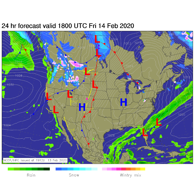
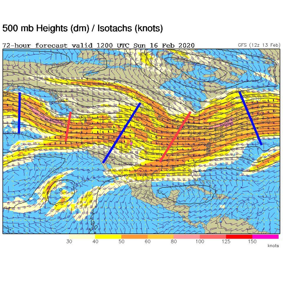
Figure 1: The forecast surface map for Friday am from NCEP.
Figure 2: The 500mb forecast upper air analysis for early Sunday morning. Pink dot is Longmont. Red lines are troughs, blue lines are ridges.
Figure 3: the graphical forecast for the next 10 days for Longmont, CO from weatherunderground.com
Figure 4: 10:1 (snow to liquid) snowfall totals through Thursday morning from the GFS and weather5280com for Colorado made Monday afternoon.
Figure 5: the model predictions of the ENSO index from the IRI.

Current Weather

Partly sunny

Partly sunny

65°F

UV Index
0 Low
Pressure
29.88 Steady
Visibility
8 miles
Dewpoint
43 °F
Humidity
44%
Wind
N 4.2 mph
Gust
8.9 mph
Wind Chill
65 °F

Hourly Forecast

Today
9 PM
60°F
Mostly cloudy
Today
10 PM
57°F
Mostly cloudy
Today
11 PM
55°F
Mostly cloudy
Tomorrow
12 AM
52°F
Intermittent clouds
Tomorrow
1 AM
50°F
Partly cloudy
Tomorrow
2 AM
49°F
Mostly clear
Tomorrow
3 AM
47°F
Mostly clear
Tomorrow
4 AM
45°F
Clear
Tomorrow
5 AM
43°F
Mostly clear
Tomorrow
6 AM
41°F
Mostly clear
Tomorrow
7 AM
44°F
Partly sunny
Tomorrow
8 AM
49°F
Partly sunny

7 Day Forecast

Mostly sunny

Wednesday

75 °F

Pleasant and warmer with sunshine and patchy clouds


Partly cloudy

Wednesday Night

41 °F

Patchy clouds


Mostly cloudy w/ t-storms

Thursday

75 °F

Turning cloudy, warm; breezy, a thunderstorm around in the afternoon


Thunderstorms

Thursday Night

49 °F

A thunderstorm in spots in the evening; otherwise, considerable cloudiness


Showers

Friday

70 °F

Mostly cloudy with a couple of showers


Thunderstorms

Friday Night

46 °F

Cloudy with showers and thunderstorms


Rain

Saturday

50 °F

Chilly with periods of rain


Rain and snow

Saturday Night

39 °F

Cloudy with rain, mixed with a little snow late


Mostly cloudy

Sunday

59 °F

Mostly cloudy with a stray thundershower in the afternoon


Partly cloudy

Sunday Night

36 °F

Partly cloudy


Sunrise and Sunset

Sunrise
6:08 AM
Sunset
7:49 PM

Based on AccuWeather data