Skip to content

Next Storm/Next Snow Forecast Discussion from the Cherrywood Observatory – February 13, 2019

This content was originally published by the Longmont Observer and is licensed under a Creative Commons license.

Forecast Discussion:

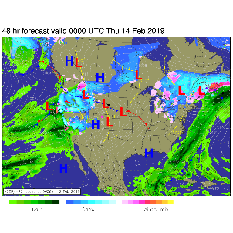
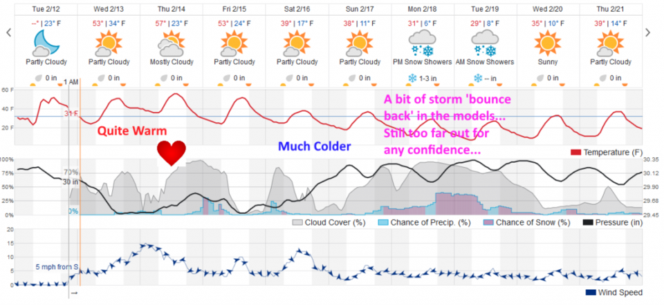
Things are on track. A ridge sits overhead and down slope flow/winds will keep us warm in the 50's F. The next system is slowly approaching from the west (Figure 1). Figure 2 shows we stay in the 50's F through Friday (Figure 2).

The longer range forecast:

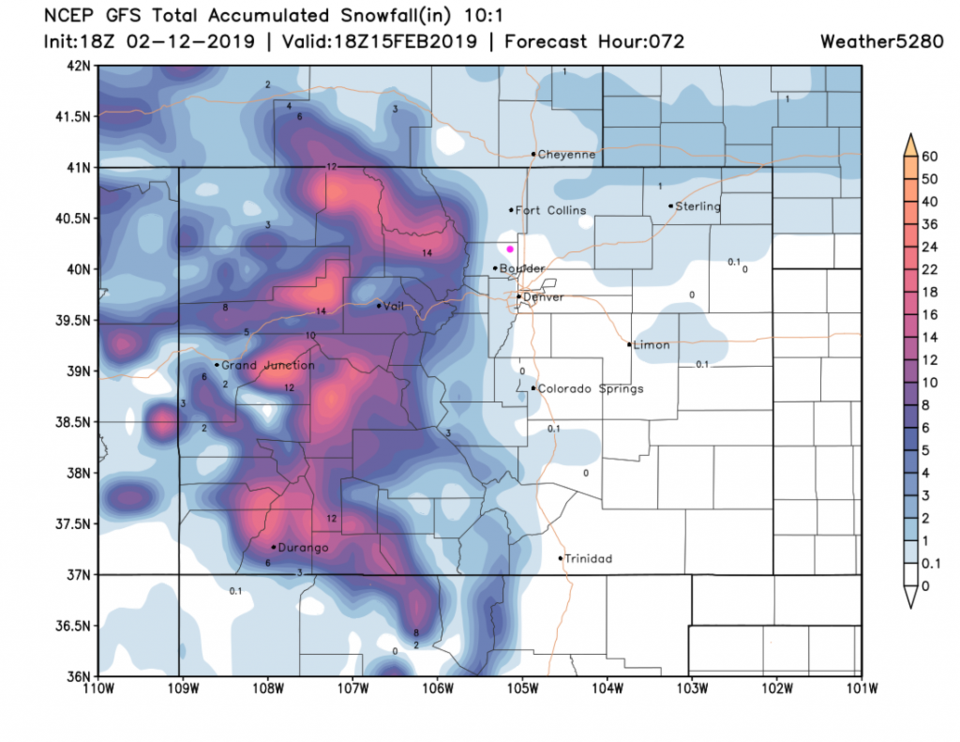
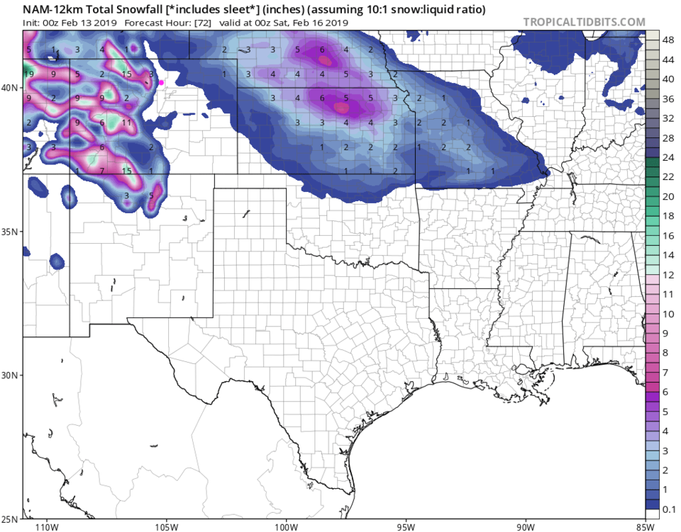
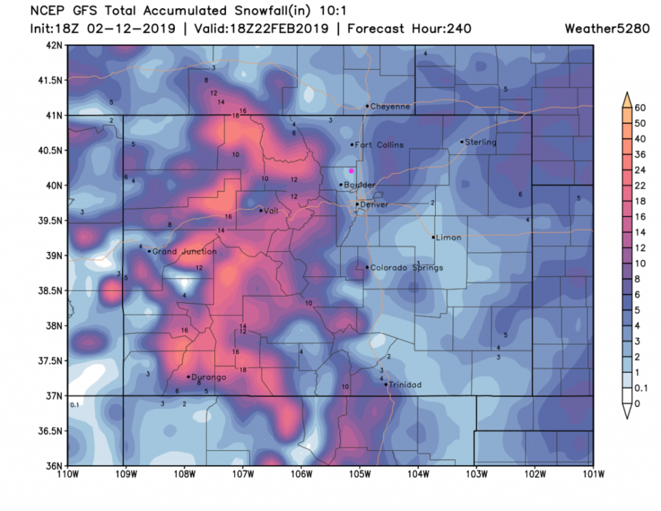
We have a very small chance of snow later Thursday into Friday AM, then again Saturday AM. The GFS (Figure 3) lays down a coating to maybe an inch of snow around town... you may get a luck dusting. The NAM limits the light snow to the western side of Longmont (Figure 4).

Our big snow storm next week, that faded to nearly nothing yesterday, is back with 1-3 or 2-4 inches of snow Sunday night into Wednesday morning (Figure 2). We can say that Saturday on will be cold, with more confidence. letting the GFS make things up for 10 days, it gives us 1-2 inches of snow over that long stretch of time. More to come! Have a nice Valentines Day!

Figure 1: The forecast surface map for Wednesday PM. From NCEP.
Figure 2: the graphical forecast for the next 10 days for Longmont, CO from weatherunderground.com
Figure 3: the forecast accumulated snow map from the GFS and weather5280.com for Colorado, through Friday noon.
Figure 4: the forecast accumulated snow map from the NAM and tropicaltidbits.com for Colorado, through Friday PM.
Figure 5: the forecast accumulated snow map from the GFS and weather5280.com for Colorado, through the next 10 days.

Current Weather

Mostly clear

Mostly clear

58°F

UV Index
0 Low
Pressure
29.9 Rising
Visibility
7 miles
Dewpoint
41 °F
Humidity
54%
Wind
NNW 4 mph
Gust
7.6 mph
Wind Chill
58 °F

Hourly Forecast

Today
11 PM
55°F
Mostly cloudy
Tomorrow
12 AM
53°F
Intermittent clouds
Tomorrow
1 AM
51°F
Partly cloudy
Tomorrow
2 AM
49°F
Mostly clear
Tomorrow
3 AM
47°F
Mostly clear
Tomorrow
4 AM
45°F
Clear
Tomorrow
5 AM
43°F
Mostly clear
Tomorrow
6 AM
41°F
Mostly clear
Tomorrow
7 AM
45°F
Partly sunny
Tomorrow
8 AM
49°F
Partly sunny
Tomorrow
9 AM
55°F
Partly sunny
Tomorrow
10 AM
62°F
Intermittent clouds

7 Day Forecast

Mostly sunny

Wednesday

75 °F

Mostly sunny, pleasant and warmer


Partly cloudy

Wednesday Night

41 °F

Patchy clouds


Mostly cloudy w/ t-storms

Thursday

75 °F

Turning cloudy, warm; breezy, a thunderstorm around in the afternoon


Thunderstorms

Thursday Night

49 °F

A thunderstorm in spots in the evening; otherwise, considerable cloudiness


Thunderstorms

Friday

70 °F

Mostly cloudy with a couple of thundershowers


Thunderstorms

Friday Night

46 °F

Cloudy with a couple of thundershowers


Rain

Saturday

50 °F

Chilly with periods of rain


Rain and snow

Saturday Night

39 °F

Cloudy with rain, mixed with a little snow late


Mostly cloudy

Sunday

59 °F

Mostly cloudy with a stray thundershower in the afternoon


Partly cloudy

Sunday Night

36 °F

Partly cloudy


Sunrise and Sunset

Sunrise
6:08 AM
Sunset
7:49 PM

Based on AccuWeather data