Skip to content

9am Update:Next Storm/Next Snow Forecast Discussion from the Cherrywood Observatory – February 11, 2019

This content was originally published by the Longmont Observer and is licensed under a Creative Commons license.

9am Update:

Weak up slope flow associated with the front and shortwave creating snow in the mountains (again) has formed freezing fog and very light snow along I-25. This looks like it will clear around noon. There are no watches or warnings associated with this weather situation. Just don't slip!

End 9am update.

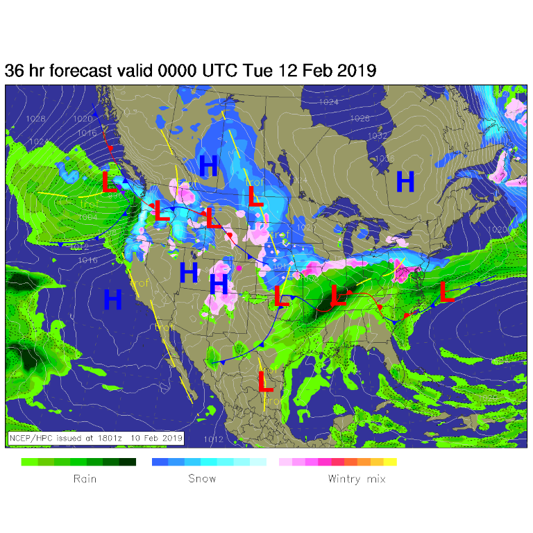
A very small amount of snow made it to I-25 in Larimer county (not shown) Saturday night, but nothing hit Boulder county. We remain dry today with some warming with a ridge overhead and down-slope flow from the ongoing snow showers on the Western Slopes (Figure 1).

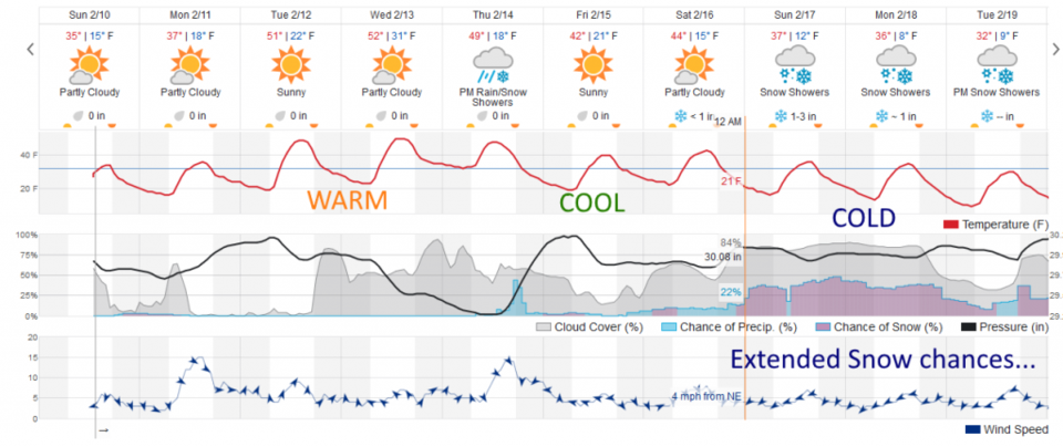
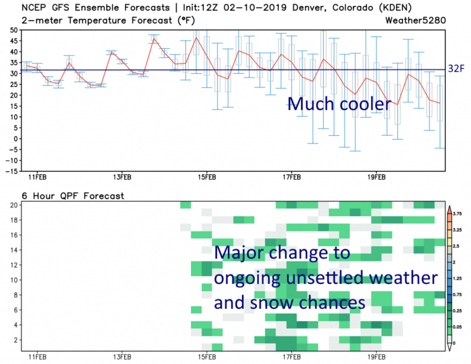
We warm to the 50's for the middle of the week (Figure 2), then start a good cool down (more on that in the longer range forecast). The GFS (Figure 3) has us completely dry through Thursday AM.

The longer range forecast:

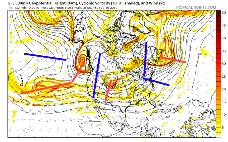
By Friday, after some Thursday PM shower chances, the cool down and change begins (Figure 2 and 3). What starts to occur is an overall trough pattern settling into the west with short wave after short wave moving over the state embedded in the northern branch of the jet stream (Figure 4). Thursday night's showers are kicked off by the short wave drawn over western Colorado in Figure 4.

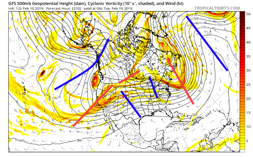
After Saturday - there are daily snow chances with high temperatures only rising to the lower 30's F most days (Figure 2 and 3). The overall trough, with shortwaves, keeps us cool and moist even up to next Tuesday (Figure 5).

Change is coming after Valentines Day. I'll try to add a heart to the graphical forecast when used this week.

Figure 1: The forecast surface map for Monday PM. From NCEP.
Figure 3: the graphical forecast for the next 10 days for Longmont, CO from weatherunderground.com
Figure 3: 10 day meteogram from weather5280.com for DIA.
Figure 4: The 500mb forecast upper air analysis for Thursday PM from the GFS and tropicaltidbits.com. Pink dot is Longmont. Red lines are troughs, blue lines are ridges.
Figure 5: The 500mb forecast upper air analysis for Tuesday early AM from the GFS and tropicaltidbits.com. Pink dot is Longmont. Red lines are troughs, blue lines are ridges.

Current Weather

Mostly sunny

Mostly sunny

64°F

UV Index
4 Moderate
Pressure
29.59 Steady
Visibility
7 miles
Dewpoint
37 °F
Humidity
37%
Wind
WNW 4.6 mph
Gust
11.2 mph
Wind Chill
64 °F

Hourly Forecast

Today
11 AM
66°F
Cloudy
Today
12 PM
67°F
Cloudy
Today
1 PM
68°F
Mostly cloudy
Today
2 PM
69°F
Mostly cloudy
Today
3 PM
70°F
Mostly cloudy
Today
4 PM
68°F
Mostly cloudy
Today
5 PM
66°F
Cloudy
Today
6 PM
63°F
Thunderstorms
Today
7 PM
59°F
Cloudy
Today
8 PM
56°F
Cloudy
Today
9 PM
53°F
Cloudy
Today
10 PM
51°F
Thunderstorms

7 Day Forecast

Mostly cloudy w/ t-storms

Friday

70 °F

Some sun, then increasing clouds with a couple of thundershowers this afternoon; gusty winds and small hail can accompany any downpour


Thunderstorms

Friday Night

44 °F

Cloudy; a couple of showers and a thunderstorm this evening followed by periods of rain late; gusty winds and small hail can accompany any downpour


Rain

Saturday

47 °F

Chilly with periods of rain and a thunderstorm; travel in the foothills and mountains will be slippery due to snow


Rain and snow

Saturday Night

36 °F

Cloudy with rain, mixed with a little snow late; travel in the foothills and mountains will be slippery due to snow


Mostly cloudy

Sunday

61 °F

Mostly cloudy and warmer


Intermittent clouds

Sunday Night

36 °F

A thunderstorm in spots in the evening; otherwise, partly cloudy


Partly sunny

Monday

71 °F

Partly sunny, pleasant and warmer


Partly cloudy

Monday Night

45 °F

Partly cloudy


Mostly sunny

Tuesday

73 °F

Pleasant with sunshine and patchy clouds


Partly cloudy

Tuesday Night

43 °F

Partly cloudy


Sunrise and Sunset

Sunrise
6:06 AM
Sunset
7:51 PM

Based on AccuWeather data