Skip to content

Next Storm/Next Snow Forecast Discussion from the Cherrywood Observatory – December 28, 2018

This content was originally published by the Longmont Observer and is licensed under a Creative Commons license.

Forecast Discussion:

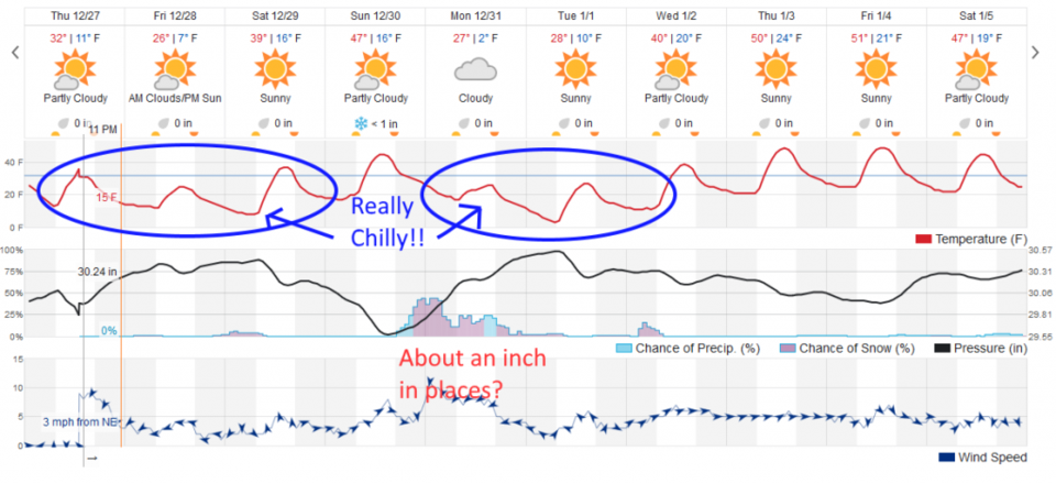
Here comes the cold!!  (And a bit of snow.)

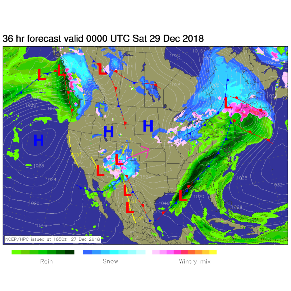
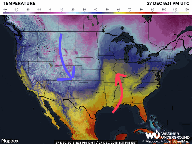
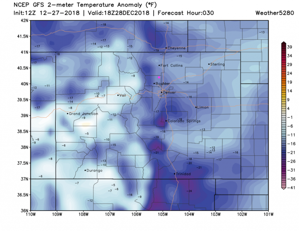
While a GIANT storm moves off into the eastern U.S., another, smaller storm is moving through the desert southwest towards us and regions south (Figure 1). With my added colored arrows (Figure 2) you can see the big swap of cold and hot air going on (Texas had severe weather because of this 'clash'). Temperatures today will be 16-18F below normal with a high only around 25F. Brrrr. (Figure 3)

Figure 1: The forecast surface map for Friday PM. From NCEP.

Figure 2: Actual temperatures Thursday afternoon from weatherunderground.com

Figure 3: The forecast temperature departure from normal map from the GFS and weather5280.com for Colorado, for midday Friday.

The loner range forecast:

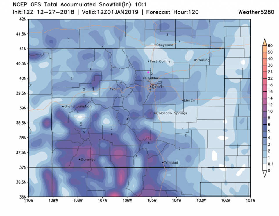
This very cold period will extend through Saturday. We have a brief warm up on Sunday to a few degrees above normal with a warm front, then another cold front brings in a inch or two of snow Sunday night into Monday morning (New Year's Eve) - Figure 4.  That Monday-Tuesday cold shot will be as sharp as what we are experiencing today (Friday).  The snowfall (from the GFS) is heavier to the southwest and southern parts of Colorado - still Longmont may pull 1-2" from this model (Figure 5).

Figure 4: the graphical forecast for the next 10 days forecast for Longmont, CO from weatherunderground.com

Figure 5: The forecast accumulated snow map from the GFS and weather5280.com for Colorado, through New Years midday.

Current Weather

Mostly sunny

Mostly sunny

72°F

UV Index
8 Very High
Pressure
29.99 Falling
Visibility
8 miles
Dewpoint
44 °F
Humidity
36%
Wind
E 2.8 mph
Gust
6.4 mph
Wind Chill
72 °F

Hourly Forecast

Today
3 PM
74°F
Mostly sunny
Today
4 PM
76°F
Mostly sunny
Today
5 PM
75°F
Mostly sunny
Today
6 PM
72°F
Mostly sunny
Today
7 PM
69°F
Mostly sunny
Today
8 PM
65°F
Intermittent clouds
Today
9 PM
61°F
Mostly cloudy
Today
10 PM
58°F
Mostly cloudy
Today
11 PM
56°F
Mostly cloudy
Tomorrow
12 AM
53°F
Intermittent clouds
Tomorrow
1 AM
51°F
Partly cloudy
Tomorrow
2 AM
49°F
Mostly clear

7 Day Forecast

Mostly sunny

Wednesday

76 °F

Mostly sunny, pleasant and warmer


Partly cloudy

Wednesday Night

42 °F

Patchy clouds


Mostly cloudy w/ t-storms

Thursday

74 °F

Becoming cloudy; breezy in the afternoon with a thunderstorm in spots


Cloudy

Thursday Night

49 °F

Considerable cloudiness


Showers

Friday

67 °F

Mostly cloudy with a couple of showers


Thunderstorms

Friday Night

46 °F

Cloudy with showers and thunderstorms


Rain

Saturday

50 °F

Chilly with periods of rain


Rain

Saturday Night

39 °F

Cloudy with steady rain becoming intermittent


Mostly cloudy

Sunday

59 °F

Mostly cloudy and warmer; a stray afternoon thundershower


Partly cloudy

Sunday Night

38 °F

Partly cloudy


Sunrise and Sunset

Sunrise
6:08 AM
Sunset
7:49 PM

Based on AccuWeather data