Skip to content

Wed 10pm Update: Next Storm/Next Snow Forecast Discussion from the Cherrywood Observatory – December 26-27, 2018

This content was originally published by the Longmont Observer and is licensed under a Creative Commons license.

Forecast Discussion:

Wednesday 10pm update:

Not much is changing in the forecast, and I've spent the day traveling to a far away city, so let me touch on the highlights for the next few days and I'll be back tomorrow:

A dry cold front comet through later today (Thursday), winds kick up to notable levels, then the temperatures drop further. We'll stay below freezing for the next 36-48 hours. As we warm a bit on Saturday, another system moves in giving us a coating to 1 inch of snow.    It is pretty much what we covered yesterday (below...).

End update 10pm Wed.

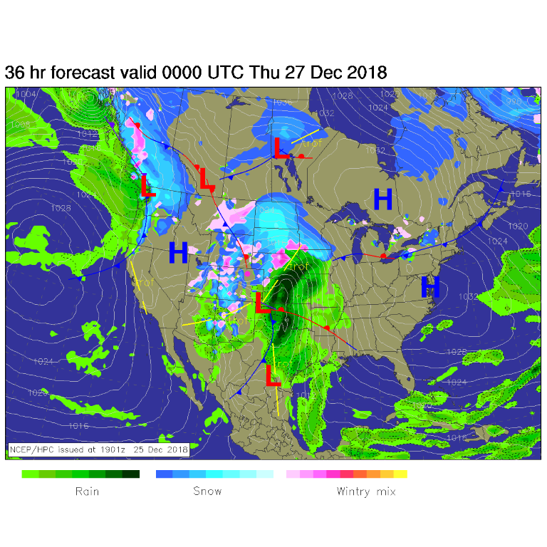
Christmas Day was very mild and beautiful (unless you only think snow is beautiful on Christmas Day). There IS a big storm gathering in the U.S. southwest (Figure 1). By tonight, the low is in the Oklahoma panhandle with rain and snow is falling in every direction around Longmont, but down slope flow is not allowing much to hit right here.  Sheesh!  (Figure 2).

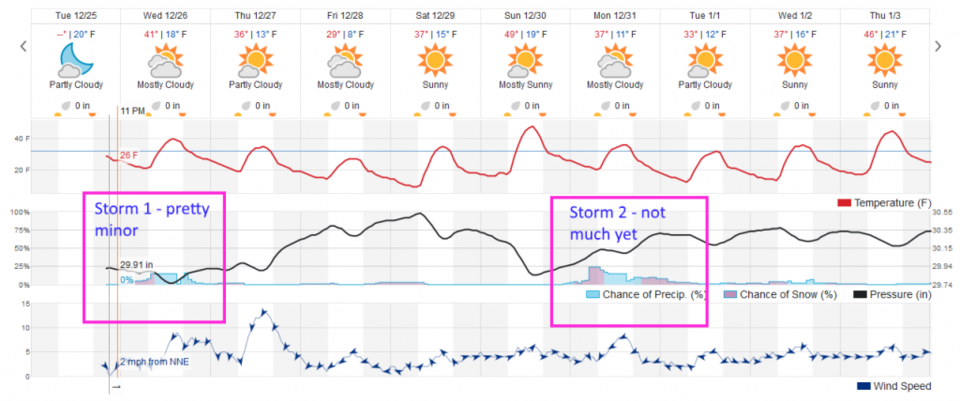
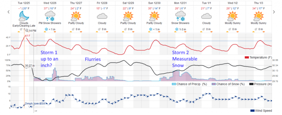
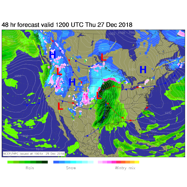
By Thursday morning, there are some snow/sleet/ice chances exist around town, but they are not very high chances (Figure 3). Figure 4 shows only about a 20% chance of precipitation from Wednesday (today) through Thursday AM. (Even Estes Park isn't expecting much more than a coating to an inch out of this storm - Figure 5).

Figure 1: The current surface map from Tuesday PM and the Weather Channel.

Figure 2: The forecast surface map for Wednesday AM. From NCEP.

Figure 3: The forecast surface map for Thursday AM. From NCEP.

The longer range forecast:

We stay very cold for a few days not warming up until Sunday (Figure 4). Another storm moves in for New Year's Eve with low (at this time) chances of snow. Figure 5 shows flurries during the very cold period Thursday-Friday in Estes Park and the next storm, for the New Year, maybe giving them 1-3 inches of snow accumulation. That is a long way out though and much can change before we get there.

Figure 4: the graphical forecast for the next 10 days forecast for Longmont, CO from weatherunderground.com

Figure 5: the graphical forecast for the next 10 days forecast for Estes Park, CO from weatherunderground.com

Current Weather

Mostly cloudy

Mostly cloudy

50°F

UV Index
0 Low
Pressure
30.14 Falling
Visibility
8 miles
Dewpoint
45 °F
Humidity
83%
Wind
NW 1.7 mph
Gust
2.8 mph
Wind Chill
50 °F

Hourly Forecast

Tomorrow
12 AM
48°F
Mostly cloudy
Tomorrow
1 AM
46°F
Intermittent clouds
Tomorrow
2 AM
45°F
Intermittent clouds
Tomorrow
3 AM
43°F
Intermittent clouds
Tomorrow
4 AM
42°F
Intermittent clouds
Tomorrow
5 AM
41°F
Intermittent clouds
Tomorrow
6 AM
40°F
Intermittent clouds
Tomorrow
7 AM
42°F
Intermittent clouds
Tomorrow
8 AM
47°F
Mostly sunny
Tomorrow
9 AM
52°F
Mostly sunny
Tomorrow
10 AM
57°F
Mostly sunny
Tomorrow
11 AM
63°F
Mostly sunny

7 Day Forecast

Mostly cloudy w/ showers

Tuesday

63 °F

Turning cloudy and cooler; a passing afternoon shower or two


Partly cloudy w/ t-storms

Tuesday Night

40 °F

Partly cloudy


Mostly sunny

Wednesday

76 °F

Pleasant and warmer with sunshine and patchy clouds


Partly cloudy

Wednesday Night

42 °F

Patchy clouds


Mostly cloudy w/ t-storms

Thursday

73 °F

Becoming cloudy; breezy in the afternoon with a thunderstorm in spots


Cloudy

Thursday Night

48 °F

A thunderstorm in spots in the evening; otherwise, considerable cloudiness


Showers

Friday

69 °F

Mostly cloudy with a couple of showers


Cloudy

Friday Night

46 °F

Cloudy


Showers

Saturday

53 °F

Cloudy and cooler with a couple of showers


Showers

Saturday Night

39 °F

Cloudy with occasional rain and drizzle late


Sunrise and Sunset

Sunrise
6:10 AM
Sunset
7:48 PM

Based on AccuWeather data