Skip to content

Next Storm/Next Snow Forecast Discussion from the Cherrywood Observatory – December 16, 2018

This content was originally published by the Longmont Observer and is licensed under a Creative Commons license.

Forecast Discussion:

Dry, and warm, weather dominates the entire western U.S. while record rainfall hits the east (that's the way it happens sometimes - Figure 1).  We remain above normal in temperature and dry (almost up to 60F most days and above 60F at the end of the week!! Figure 2) for days and days. Blobs of moisture will pass now and then creating cloudy skies, but there isn't much to note in the short term.

Figure 1: The current surface map from Saturday PM and the Weather Channel.

Figure 2: the graphical forecast for the next 10 days forecast for Longmont, CO from weatherunderground.com

The longer range forecast and Christmas snow forecast:

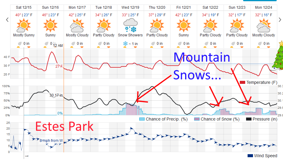
Our chances of rain or snow, from weatherunderground, are down around 3-5% next weekend (Figure 2). Storm systems will be impacting the state, even if they don't do anything around Longmont.  Figure 3 shows Estes park getting about an inch of snow Wednesday and some snow Saturday through Christmas Day.  You don't have to drive far to see snow.

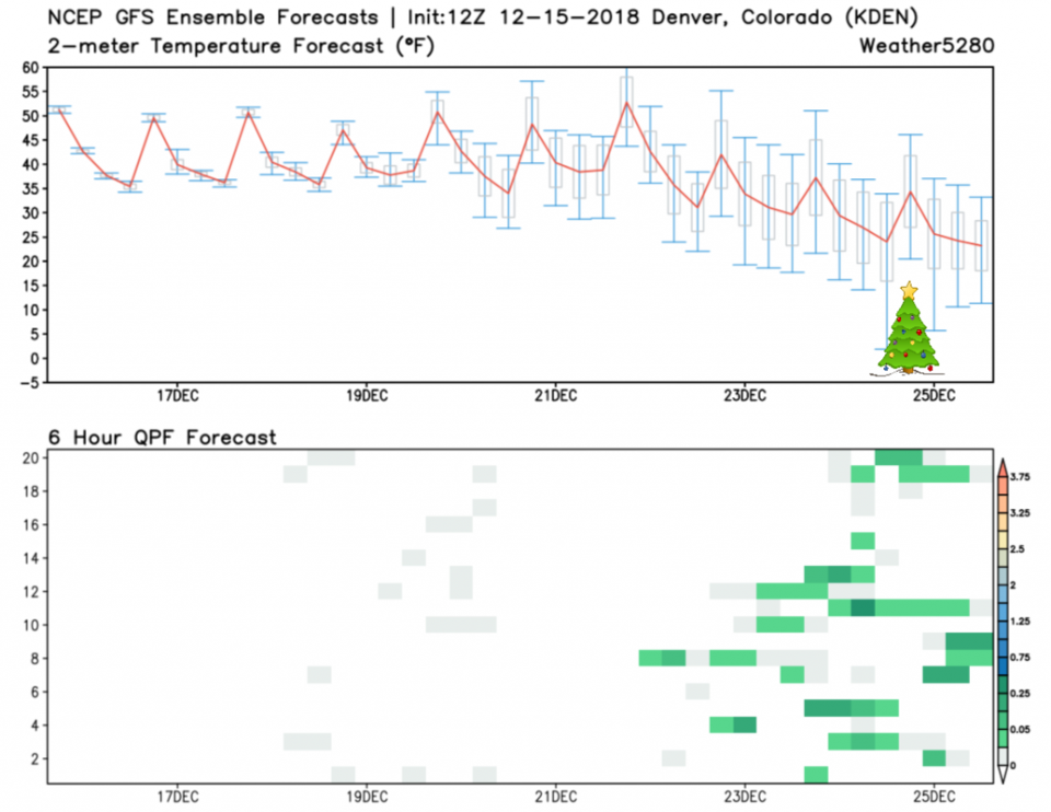
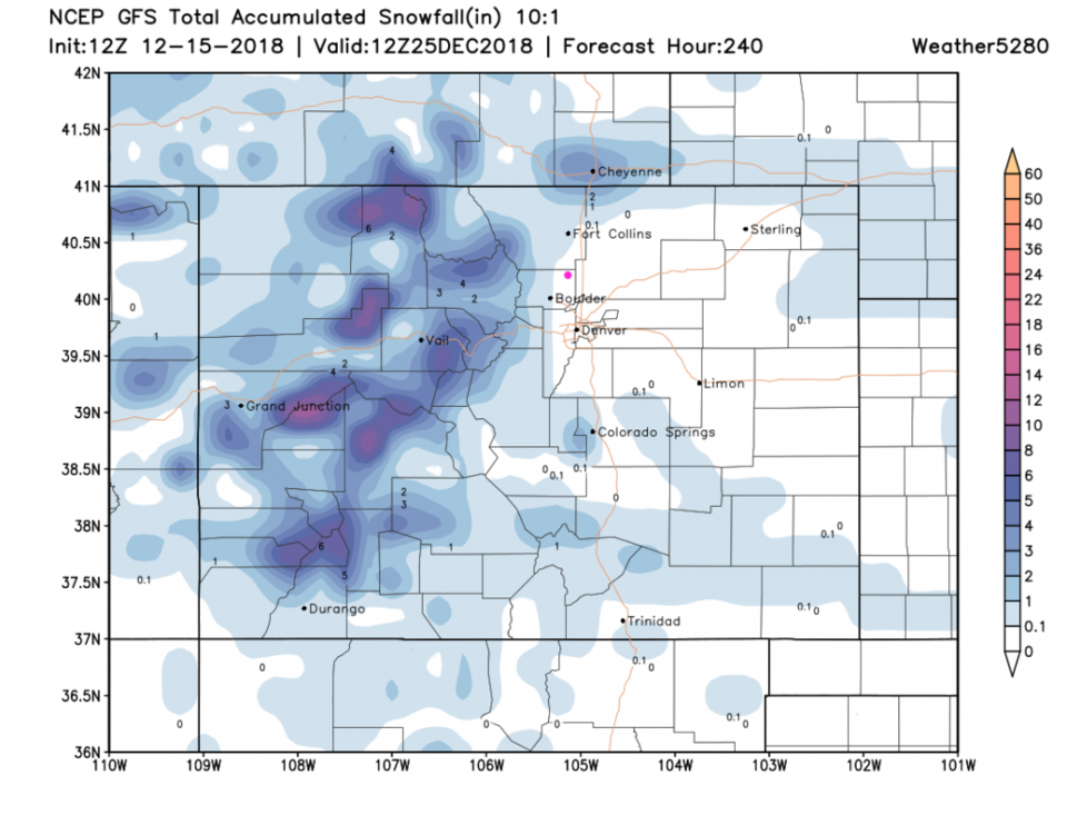
Figure 4, the ensemble runs from the GFS does show some runs giving Denver precipitation as temperatures start to cool after the 22nd. The GFS (Figure 5) has the mountains getting up to 10 inches of snow over the next 10 days... even Boulder might get a coating to an inch in this time period.

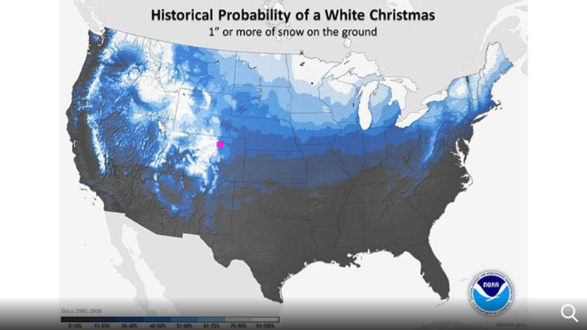
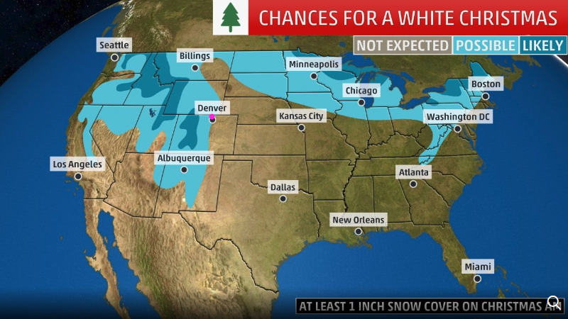
The big picture climatology of a White Christmas is given by NOAA in Figure 6.  We have a pretty good chance, compared to much of the country, normally.  The weather channel puts us on the edge of a 'possible' category for a White Christmas - Figure 7 - this year.   It's not likely, but it is not off the table either.  Write a note to Santa real quick...

Figure 3: the graphical forecast for the next 10 days forecast for Estes Park, CO from weatherunderground.com

Figure 4: 10 day meteogram from weather5280.com for DIA.

Figure 5: The forecast accumulated snow map from the GFS and weather5280.com for Colorado, through the next 10 days.

Figure 6: The historical probability of a white Christmas (1" or more) from NOAA for the U.S.

Figure 7: the forecasted chance of a White Christmas this year from the weatherchannel.com

Current Weather

Clear

Clear

50°F

UV Index
0 Low
Pressure
29.89 Falling
Visibility
7 miles
Dewpoint
43 °F
Humidity
77%
Wind
NNW 3.3 mph
Gust
7.8 mph
Wind Chill
50 °F

Hourly Forecast

Today
4 AM
45°F
Clear
Today
5 AM
43°F
Mostly clear
Today
6 AM
41°F
Mostly clear
Today
7 AM
45°F
Partly sunny
Today
8 AM
52°F
Partly sunny
Today
9 AM
59°F
Partly sunny
Today
10 AM
65°F
Intermittent clouds
Today
11 AM
71°F
Intermittent clouds
Today
12 PM
75°F
Intermittent clouds
Today
1 PM
77°F
Intermittent clouds
Today
2 PM
75°F
Thunderstorms
Today
3 PM
73°F
Cloudy

7 Day Forecast

Mostly sunny

Wednesday

75 °F

Mostly sunny, pleasant and warmer


Partly cloudy

Wednesday Night

41 °F

Patchy clouds


Mostly cloudy w/ t-storms

Thursday

77 °F

Turning cloudy, warm; breezy, a stray thunderstorm this afternoon


Thunderstorms

Thursday Night

47 °F

A thunderstorm in spots this evening; otherwise, considerable cloudiness


Thunderstorms

Friday

69 °F

Mostly cloudy and not as warm with a couple of thundershowers


Thunderstorms

Friday Night

44 °F

Cloudy with a couple of thundershowers


Rain

Saturday

46 °F

Chilly with periods of rain and a thunderstorm


Rain and snow

Saturday Night

39 °F

Cloudy with rain, mixed with a little snow late


Mostly cloudy

Sunday

59 °F

Mostly cloudy and warmer; a stray afternoon thundershower


Partly cloudy

Sunday Night

36 °F

Partly cloudy


Sunrise and Sunset

Sunrise
6:08 AM
Sunset
7:49 PM

Based on AccuWeather data