Skip to content

Next Storm/Next Snow Forecast Discussion from the Cherrywood Observatory – August 8, 2019

This content was originally published by the Longmont Observer and is licensed under a Creative Commons license.

In Brief:

The tropical (monsoonal) moisture is arriving today (Thursday) and looks like it will linger through the start or middle of next week. Severe weather - super-cells with large hail and damaging winds, as well as thunderstorms dropping locally flooding amounts of rain are possible today. Wet and sometimes stormy (locally flooding) weather will continue through the Monday/Tuesday time frame.

Forecast Discussion:

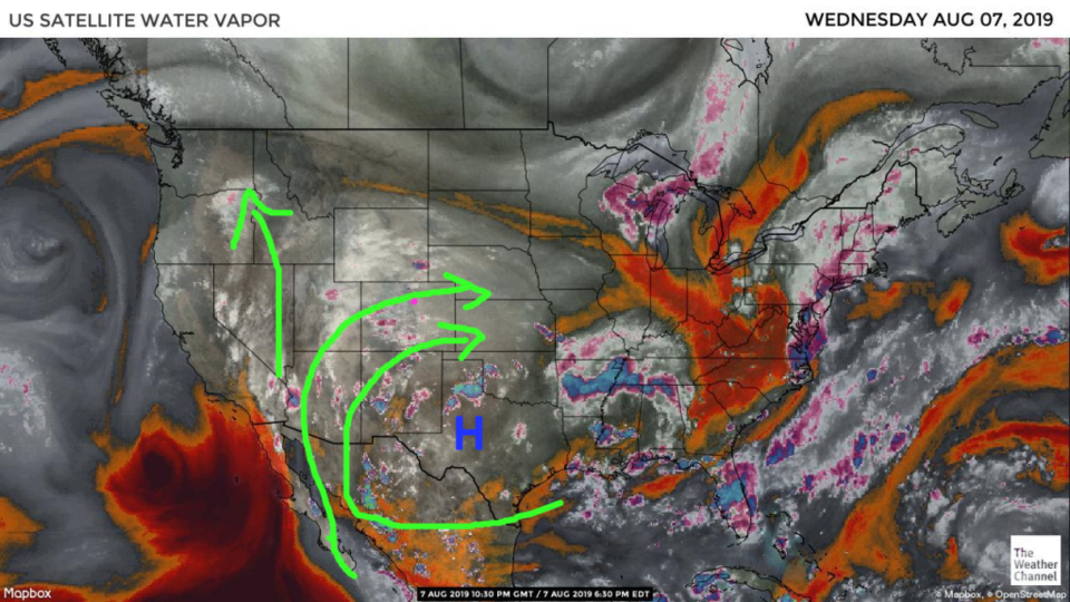
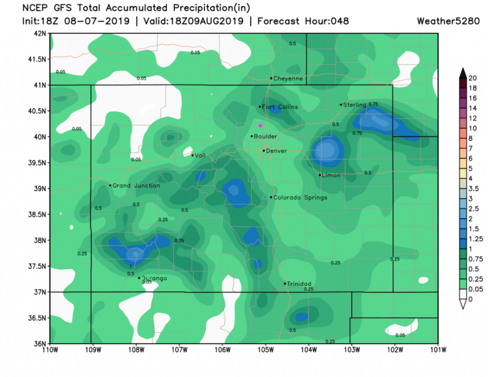
The upper high has inched into Texas on its trip to Louisiana by the end of the weekend (Figure 1). Increasing amounts of mid and upper level moisture is flowing into the state while thunderstorms out east are pushing up-slope surges of moist surface air. This will result in pretty widespread showers and thunderstorms today and on into the weekend (Figure 1).

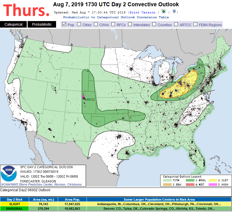
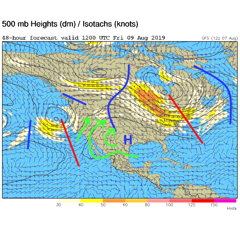
This moisture plus summer heating plus upper level short wave ripples getting to the state with the high out of the way (Figure 4) mean severe weather is possible again (Figure 3). There is a marginal risk of severe weather this afternoon with super-cell formation possible generating very large hail and strong damaging winds. With all the moisture around, thunderstorms may produce a quick inch or two of rainfall over a given location that will create flooding.

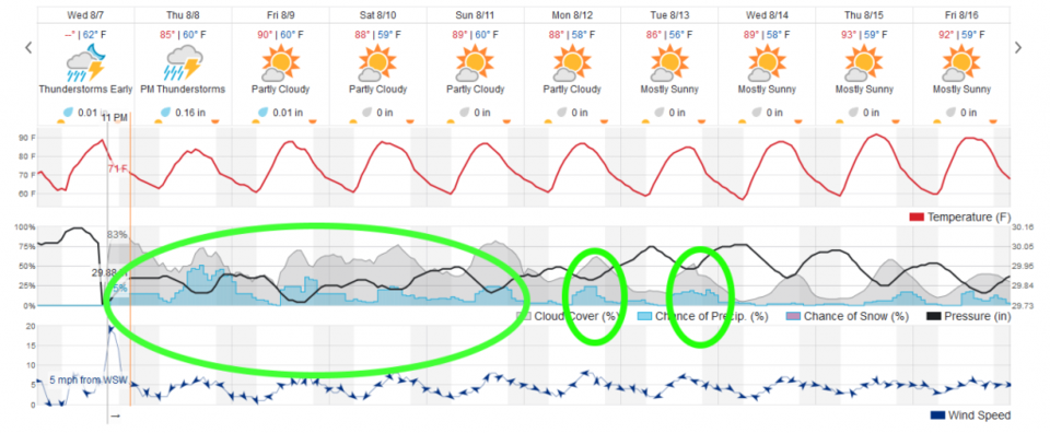
The weatherunderground model still shows less than a quarter inch of rainfall on average over the area (but again, one storm cell over town could give us inches of water). The GFS gives us less than a quarter inch of rainfall as well over the next 48 hours, but some places pick up 2 inches or more.

In fact, the NWS pointed out (opposite of my claim yesterday) we may get as much as 1.40" in precipitatable water values today - which approach record levels in meteorological history for Colorado at this time of year. That is serious moisture flow. Remember - extra cloud cover - also caused by the high moisture levels - can keep temperatures down and limit severe weather coverage. Just keep alert!

The Longer Range Forecast:

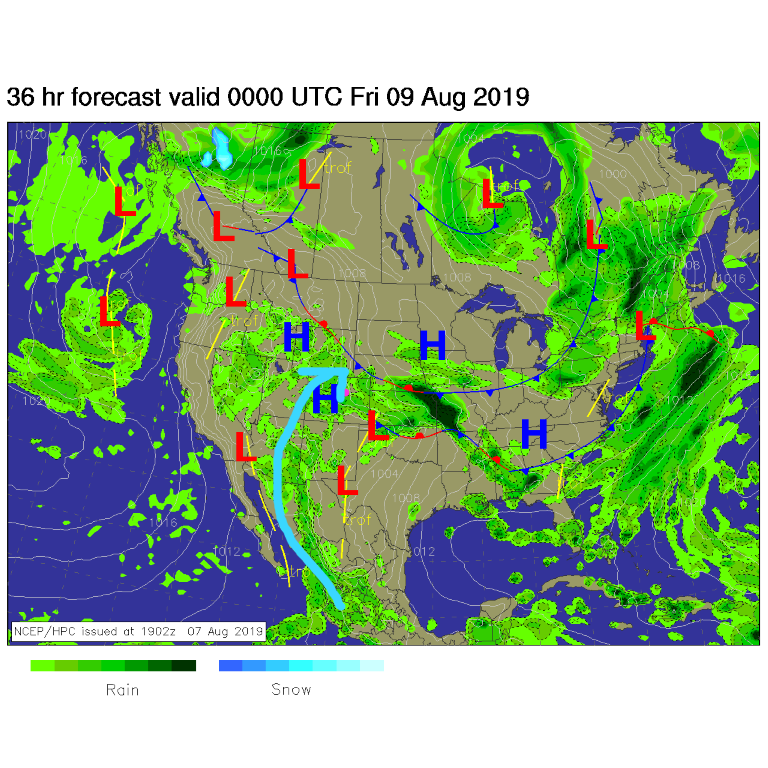
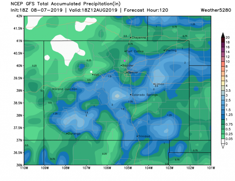
Figure 5 shows that high afternoon storm chances and lots of cloud cover will continue through Sunday. Moisture will still be in place for storms Monday and Tuesday. Looking out over the next 5 days, the GFS gives us only about a quarter inch of rain (in this run) but many places nearby pick up 1 to almost 4 inches of water. That is possible for Longmont depending on where storms track.

Figure 1: the water vapor satellite image (browns/reds are dry air, whites and light grey is moist air, purple/blue is ice and high cloud tops). From the the Weather Channel from Wednesday.
Figure 2: The forecast surface map for Wednesday night morning from NCEP.
Figure 3: The severe storm weather forecast for the U.S. from the Storm Predication Center in Norman, OK. Made Wednesday for Thursday.
Figure 4: The 500mb forecast upper air analysis for Friday AM. Pink dot is Longmont. Red lines are troughs, blue lines are ridges.
Figure 5: the graphical forecast for the next 10 days for Longmont, CO from weatherunderground.com
Figure 6: the forecast accumulated precipitation map from the GFS and weather5280.com for Colorado, for the next 2 days.
Figure 7: the forecast accumulated precipitation map from the GFS and weather5280.com for Colorado, for the next 5 days.

Current Weather

Cloudy

Cloudy

53°F

UV Index
0 Low
Pressure
30.15 Rising
Visibility
8 miles
Dewpoint
43 °F
Humidity
67%
Wind
NW 2.2 mph
Gust
4.3 mph
Wind Chill
53 °F

Hourly Forecast

Today
9 PM
54°F
Thunderstorms
Today
10 PM
50°F
Intermittent clouds
Today
11 PM
48°F
Intermittent clouds
Tomorrow
12 AM
47°F
Intermittent clouds
Tomorrow
1 AM
45°F
Intermittent clouds
Tomorrow
2 AM
45°F
Intermittent clouds
Tomorrow
3 AM
43°F
Intermittent clouds
Tomorrow
4 AM
42°F
Intermittent clouds
Tomorrow
5 AM
41°F
Intermittent clouds
Tomorrow
6 AM
40°F
Intermittent clouds
Tomorrow
7 AM
42°F
Intermittent clouds
Tomorrow
8 AM
46°F
Mostly sunny

7 Day Forecast

Mostly cloudy w/ showers

Tuesday

63 °F

Turning cloudy and cooler; a passing afternoon shower or two


Partly cloudy w/ t-storms

Tuesday Night

40 °F

An evening thundershower; otherwise, partly cloudy


Mostly sunny

Wednesday

76 °F

Pleasant and warmer with sunshine and patchy clouds


Partly cloudy

Wednesday Night

42 °F

Patchy clouds


Mostly cloudy w/ t-storms

Thursday

73 °F

Becoming cloudy; breezy in the afternoon with a thunderstorm in spots


Cloudy

Thursday Night

48 °F

Considerable cloudiness


Showers

Friday

69 °F

Mostly cloudy with a couple of showers


Thunderstorms

Friday Night

46 °F

Cloudy; thundershowers in the evening followed by periods of rain late


Showers

Saturday

53 °F

Cloudy and cooler with a couple of showers


Showers

Saturday Night

39 °F

Cloudy with occasional rain and drizzle late


Sunrise and Sunset

Sunrise
6:10 AM
Sunset
7:48 PM

Based on AccuWeather data