This content was originally published by the Longmont Observer and is licensed under a Creative Commons license.
In Brief:
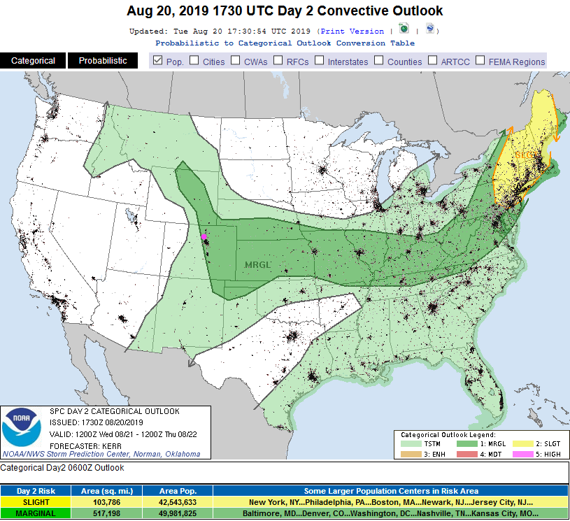
Some mid level moisture, summer heat, and passing short waves (+ some up slope moisture supply) means we'll have afternoon thunderstorms Wednesday to Friday. Wednesday is the peak of this activity with a Marginal Risk of severe weather painted for the Front Range.
3pm Update:
asdf
URGENT - IMMEDIATE BROADCAST REQUESTED
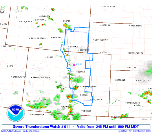
Severe Thunderstorm Watch Number 611 (See Figure 2 update)
NWS Storm Prediction Center Norman OK
245 PM MDT Wed Aug 21 2019
The NWS Storm Prediction Center has issued a
* Severe Thunderstorm Watch for portions of
Eastern Colorado
Southeast Wyoming
* Effective this Wednesday afternoon and evening from 245 PM
until 900 PM MDT.
* Primary threats include...
Scattered large hail and isolated very large hail events to 2
inches in diameter possible
Isolated damaging wind gusts to 70 mph possible
SUMMARY...Isolated severe storms, in the form of sustained
multicells and a few transient supercells, are expected to develop
along the foothills/I-25 corridor of eastern Colorado into southeast
Wyoming. Isolated large hail will be the primary risk as storms
drift east-southeastward through late afternoon/evening, although
localized severe-caliber winds could also occur, particularly across
east-central Colorado.
The severe thunderstorm watch area is approximately along and 45
statute miles east and west of a line from 75 miles north northeast
of Laramie WY to 30 miles southeast of Pueblo CO. For a complete
depiction of the watch see the associated watch outline update
(WOUS64 KWNS WOU1).
PRECAUTIONARY/PREPAREDNESS ACTIONS...
REMEMBER...A Severe Thunderstorm Watch means conditions are
favorable for severe thunderstorms in and close to the watch area.
Persons in these areas should be on the lookout for threatening
weather conditions and listen for later statements and possible
warnings. Severe thunderstorms can and occasionally do produce
tornadoes.
&&
OTHER WATCH INFORMATION...CONTINUE...WW 609...WW 610...
AVIATION...A few severe thunderstorms with hail surface and aloft to
2 inches. Extreme turbulence and surface wind gusts to 60 knots. A
few cumulonimbi with maximum tops to 450. Mean storm motion vector
32020.
...Guyer
End 3pm Update.
1:30pm Update:
I'm expecting a watch will be issued soon, but I'll let the SPC do the talking for themselves:
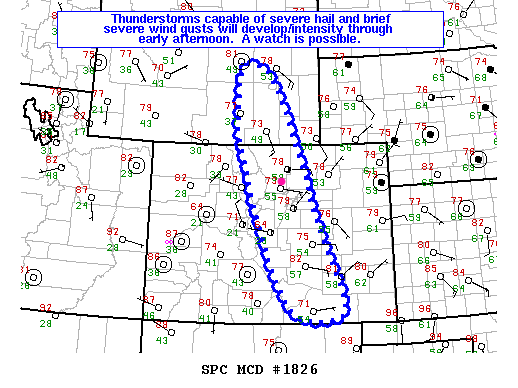
Mesoscale Discussion 1826
   NWS Storm Prediction Center Norman OK
   0151 PM CDT Wed Aug 21 2019

   Areas affected...The Colorado front range to portions of southeast
   Wyoming

   Concerning...Severe potential...Watch possible

   Valid 211851Z - 212045Z

   Probability of Watch Issuance...40 percent

   SUMMARY...Thunderstorms will develop/intensify through early
   afternoon and pose a threat for severe hail and brief severe wind
   gusts.  The potential coverage of the threat, and hence the need for
   a Severe Thunderstorm Watch, is uncertain.

   DISCUSSION...Strong heating and an approaching weak mid-upper-level
   low are contributing to deepening cumulus and initial thunderstorm
   development over the Colorado and Wyoming high terrain.  A moist and
   modifying continental polar air mass has pushed up to the foothills,
   creating an environment supportive of thunderstorms that varies
   little with latitude from the Raton Mesa northward to the Laramie
   Mountains.  By early afternoon, forecast soundings suggest this
   environment will consist of 1500-2500 J/kg of MLCAPE (higher toward
   the Mountains) with little convective inhibition, moderate
   straight-line vertical wind shear confined mostly in the 1-4 km
   layer (supportive of multicell to some transient supercell
   structures), and DCAPE of 1200-1500 J/kg.

   Given storm rotation and steep low-to-mid level lapse rates, severe
   hail is the main threat with these storms, but brief severe wind
   gusts are possible in the stronger downdrafts.  Moderate low-level
   southeasterly upslope flow combined with relatively weak
   west-northwesterly to westerly flow at 500-300 mb suggests a slow
   south to southeast motion to the cells, thus limiting the eastward
   extent of the threat.  The main uncertainty concerning the need for
   a Severe Thunderstorm Watch is the coverage of the hail/wind threat.
    The coverage of storms that mature and move into the foothills will
   be monitored in the next hour or so to better determine if a Watch
   will be needed.

   ..Coniglio/Guyer.. 08/21/2019

   ...Please see www.spc.noaa.gov for graphic product... (See Figure 1 update).
End 1:30pm Update.
Forecast Discussion:
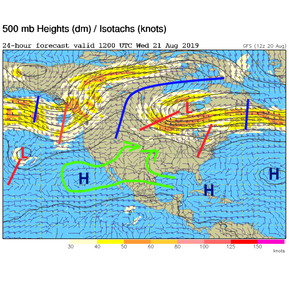
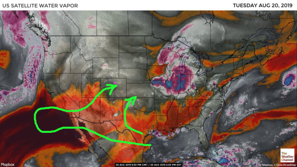
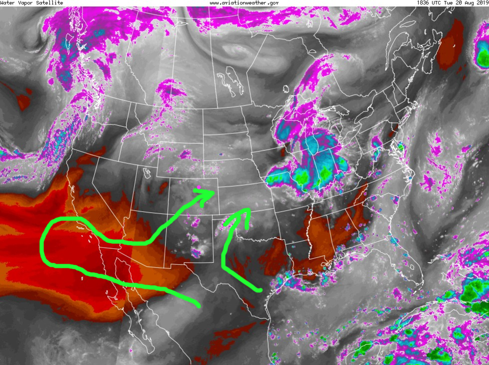
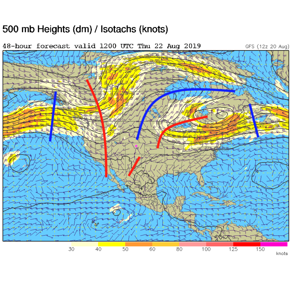
For Wednesday, even though there is a trough to the east and west of the state, the moisture is having to take quite a trip to get here. The low level moisture on the Plains is slipping back on easterly surface winds - pushed by the big thunderstorm complex that has traveled to the northern Midwestern states in the images below. The mid level moisture is almost taking a Hawaiian vacation before getting here (Figure 1). Our usual satellite image looks like the moisture is all cut off from the south (Figure 2) but Figure 3 is the same image with a different color scale. There is "some" moisture around from Texas and New Mexico up to us.
The Marginal Risk (for hail and high winds) is along this quasi-cold front created by the traveling thunderstorm masses way out east. It includes all of eastern Colorado up into the foothills.
The Longer Range Forecast:
For Thursday the west coast trough sneaks a closer and interacts with the remaining moisture, but severe weather is not expected (Figure 5). By Friday, the moisture lessens as a ridge begins to dominate our weather again. We return to the 90'sF and dry out - AGAIN (Figure 6).
Weather Trivia:
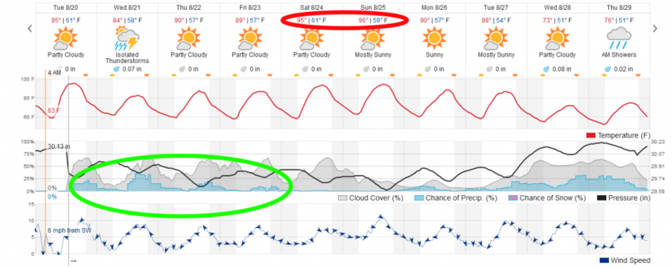
The TV stations and weather5280 are throwing out interesting - seasonal - stats. I can't skip on my trivial duty. DIA has had 36 days of 90F+ weather when it normally has 45 days up to this point. We normally have a 100+F day every other year, and we've had two (I believe) at DIA.
Speaking of snow - the average first measurable snow occurs on October 18th. The earliest Denver snow record was Sept 3rd in 1961.
August 14th also saw a new record set for a measured hail stone in our state. It fell near Bethune, CO on August 13th and beat the old record of 4.5" with 4.83" long axis and weighted 8.5 oz (some melting occurred before those measurements). I'd want to be underground if that was happening.