Skip to content

Next Storm/Next Snow Forecast Discussion from the Cherrywood Observatory – August 18-19, 2019

This content was originally published by the Longmont Observer and is licensed under a Creative Commons license.

In Brief:

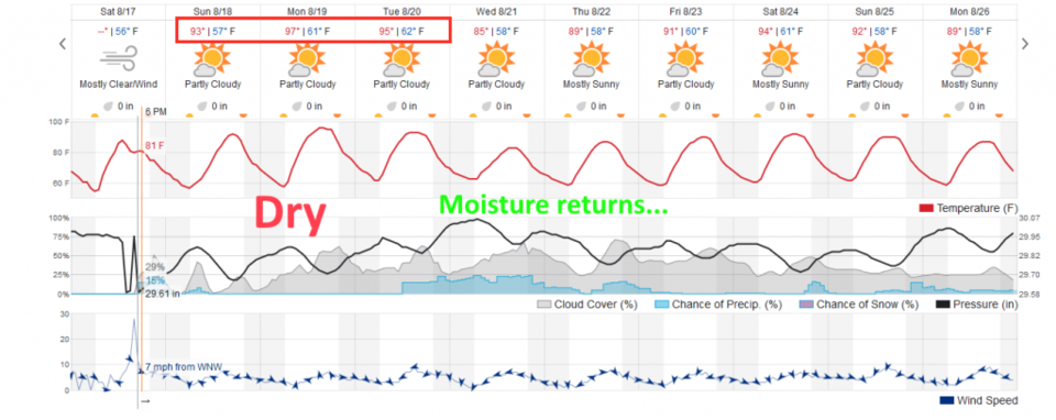
Moisture diminishes a bit as a strong ridge dominates the weather through Tuesday AM. We will see upper 90'sF until moisture returns Tuesday PM and temperatures drop about 10F.

Forecast Discussion:

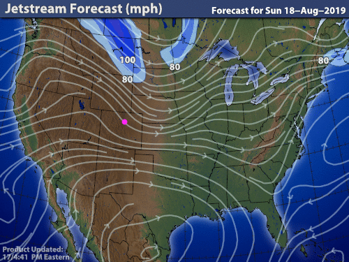
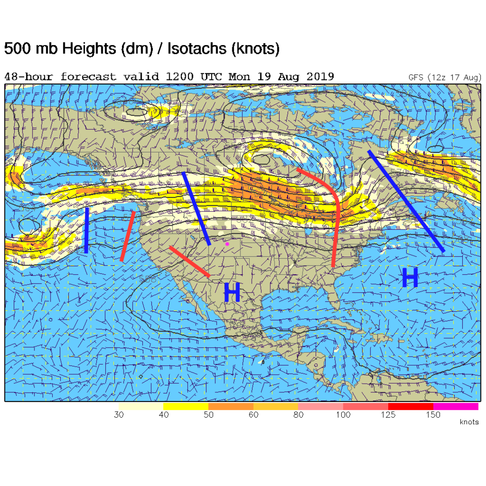
The wind flow across the nation is bringing us air flow and moisture from the west/Pacific (Figure 1). With a ridge growing over the southern U.S. and Colorado (Figure 3) - we dry out and get quite hot Sunday-Tuesday (Figure 2).

The Longer Range Forecast:

In the more distant future, the ridge will weaken, a trough takes a bite out of it by Tuesday so we see moisture return - storm chances return as well for a bit. It is going to get quiet after the Saturday clouds, winds, and showers move on.

Figure 1: Wind flow/streamline map for Sunday from the weather channel.
Figure 2: the graphical forecast for the next 10 days for Longmont, CO from weatherunderground.com
Figure 3: The 500mb forecast upper air analysis for Monday AM. Pink dot is Longmont. Red lines are troughs, blue lines are ridges.

Current Weather

Sunny

Sunny

54°F

UV Index
3 Moderate
Pressure
29.6 Steady
Visibility
8 miles
Dewpoint
45 °F
Humidity
71%
Wind
WNW 3.6 mph
Gust
12.1 mph
Wind Chill
54 °F

Hourly Forecast

Today
10 AM
59°F
Cloudy
Today
11 AM
61°F
Cloudy
Today
12 PM
64°F
Cloudy
Today
1 PM
66°F
Mostly cloudy
Today
2 PM
68°F
Mostly cloudy
Today
3 PM
70°F
Mostly cloudy
Today
4 PM
69°F
Mostly cloudy
Today
5 PM
66°F
Cloudy
Today
6 PM
63°F
Thunderstorms
Today
7 PM
59°F
Cloudy
Today
8 PM
56°F
Cloudy
Today
9 PM
53°F
Cloudy

7 Day Forecast

Thunderstorms

Friday

70 °F

Mostly cloudy with a couple of thundershowers this afternoon; gusty winds and small hail can accompany any downpour


Thunderstorms

Friday Night

44 °F

Cloudy; a couple of showers and a thunderstorm this evening followed by periods of rain late; gusty winds and small hail can accompany any downpour


Rain

Saturday

47 °F

Chilly with periods of rain and a thunderstorm; travel in the foothills and mountains will be slippery due to snow


Rain and snow

Saturday Night

36 °F

Cloudy with rain, mixed with a little snow late; travel in the foothills and mountains will be slippery due to snow


Mostly cloudy

Sunday

61 °F

Mostly cloudy and warmer


Intermittent clouds

Sunday Night

36 °F

A thunderstorm in spots in the evening; otherwise, partly cloudy


Partly sunny

Monday

71 °F

Partly sunny, pleasant and warmer


Partly cloudy

Monday Night

45 °F

Partly cloudy


Mostly sunny

Tuesday

73 °F

Pleasant with sunshine and patchy clouds


Partly cloudy

Tuesday Night

43 °F

Partly cloudy


Sunrise and Sunset

Sunrise
6:06 AM
Sunset
7:51 PM

Based on AccuWeather data