Skip to content

11:30am 8/13 Update :Next Storm/Next Snow Forecast Discussion from the Cherrywood Observatory – August 12-13, 2019

This content was originally published by the Longmont Observer and is licensed under a Creative Commons license.

In Brief:

Dry stabilizing air is moving in overnight Sunday into Monday cutting off storm chances. A giant ridge is forming across the southern U.S. turning off tropical moisture flow. We warm to the 90'sF this week with very small chances of an afternoon storm - and even then, only on some days.

11:30 am 8/13 update:

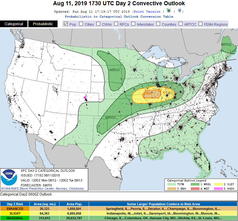
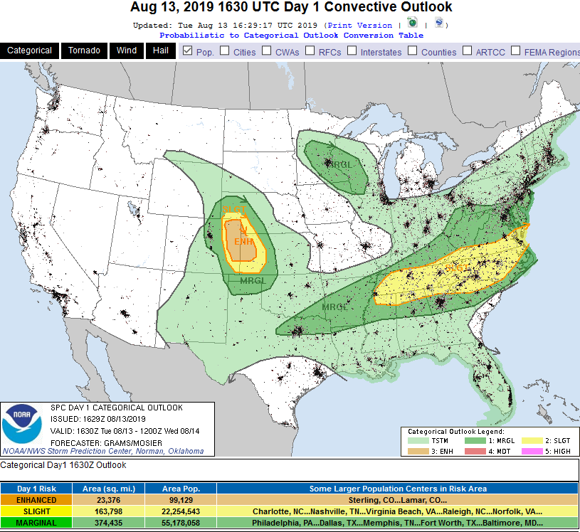
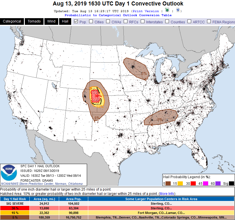
Some moisture has sneaked back into northern Colorado. With daytime heating and the direction that winds are coming from up through the atmosphere, there is a risk of a few supercell thunderstorms getting started along the Front Range this afternoon. The SPC has painted us with a Marginal Risk again (1 on a scale of 1-5 - Figure 2 update) and hail is the primary risk near Longmont and I-25 (Figure 3 update).

Further out on the Plains in the Slight and Enhanced risk (Figure 2 update) zones, high winds and tornadoes become a threat to watch for.

Figure 2 update: The severe storm weather forecast for the U.S. from the Storm Predication Center in Norman, OK. Made Tuesday for Tuesday.
Figure 3 update: The large hail forecast for the U.S. from the Storm Predication Center in Norman, OK. Made Tuesday for Tuesday.

End 11:30am 8/13 update

2pm 8/12 Update:

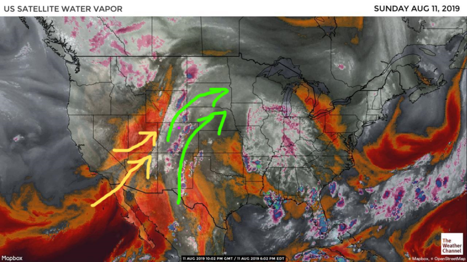
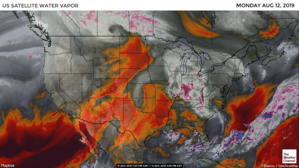
Just to follow up on the promise made yesterday - here is the water vapor image from midday Monday (Figure 1 update) showing the river of dry air flowing over the state. Looking out the window - it is really clear out there as well.

Figure 1 update: the water vapor satellite image (browns/reds are dry air, whites and light grey is moist air, purple/blue is ice and high cloud tops). From the the Weather Channel from midday Monday.

End 2pm 8/12 Update.

Forecast Discussion:

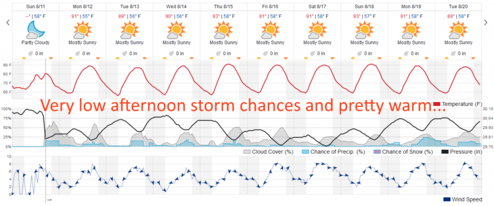
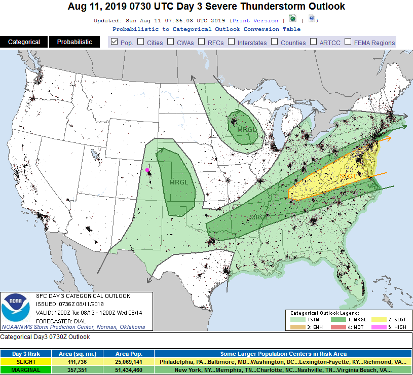
The real storms formed out over eastern Colorado with only light rain around I-25 and westward. The Denver NWS was right to be concerned about the dampening effect of too much morning cloudiness in the Marginal Risk zone Sunday. Dry air is replacing the moisture (it will be really different water vapor satellite image in the next 24-48 hours (Figure 1)). We return to the 90's with a very small chance of rain Monday (Figure 2). The SPC doesn't even give us a chance of convection on Monday (Figure 3).

The Longer Range Forecast:

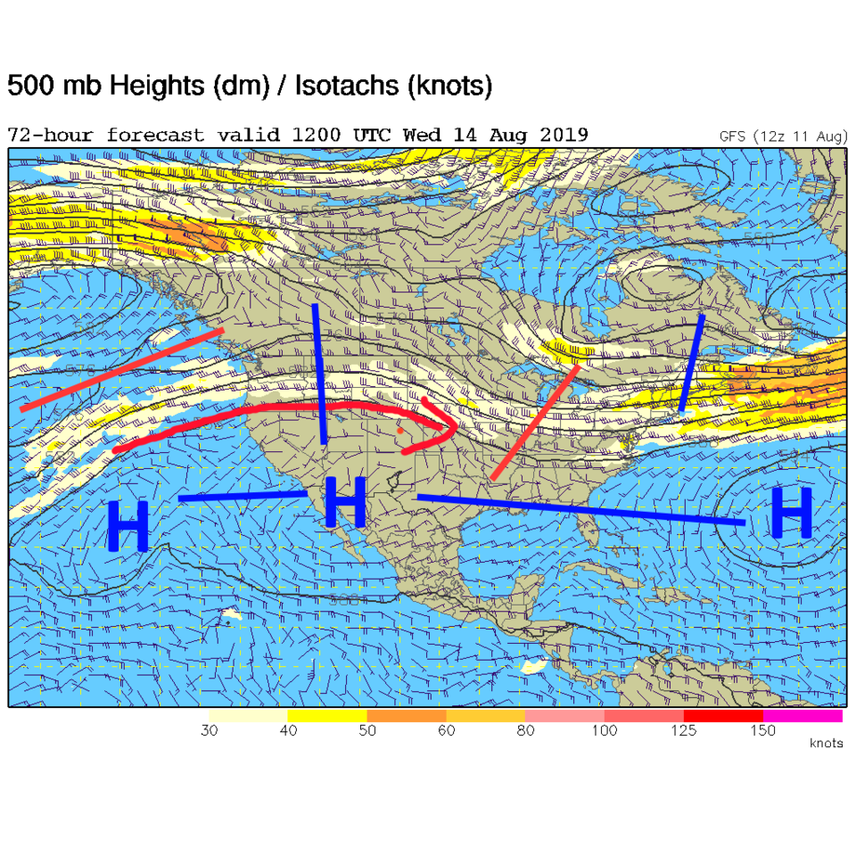
On Tuesday, healthy daytime heating will interact with what remaining moisture we still have in the atmosphere and a storm or two may form around I-25. Most will not see a drop fall (Figure 4). The dominant story is a big ridge over the western U.S. and a ridge stretching almost from Bermuda to Hawaii to our south (Figure 5). Say goodbye to rich moisture (or monsoon like) flow.

Because of this sudden onset of quiet hot weather, I'll turn to some family time and post double-day posts until things cool down and get moist again. The longer range does hint at a big cool down for later August. Wait for it!

Figure 1: the water vapor satellite image (browns/reds are dry air, whites and light grey is moist air, purple/blue is ice and high cloud tops). From the the Weather Channel from Sunday.
Figure 2: the graphical forecast for the next 10 days for Longmont, CO from weatherunderground.com
Figure 3: The severe storm weather forecast for the U.S. from the Storm Predication Center in Norman, OK. Made Sunday for Monday.
Figure 4: The severe storm weather forecast for the U.S. from the Storm Predication Center in Norman, OK. Made Sunday for Tuesday.
Figure 5: The 500mb forecast upper air analysis for Wednesday AM. Pink dot is Longmont. Red lines are troughs, blue lines are ridges.

Current Weather

Partly cloudy

Partly cloudy

58°F

UV Index
0 Low
Pressure
29.89 Steady
Visibility
5 miles
Dewpoint
44 °F
Humidity
60%
Wind
NNW 4.5 mph
Gust
9.6 mph
Wind Chill
58 °F

Hourly Forecast

Today
1 AM
52°F
Partly cloudy
Today
2 AM
50°F
Mostly clear
Today
3 AM
47°F
Mostly clear
Today
4 AM
45°F
Clear
Today
5 AM
43°F
Mostly clear
Today
6 AM
41°F
Mostly clear
Today
7 AM
45°F
Partly sunny
Today
8 AM
50°F
Partly sunny
Today
9 AM
55°F
Partly sunny
Today
10 AM
62°F
Intermittent clouds
Today
11 AM
66°F
Intermittent clouds
Today
12 PM
70°F
Intermittent clouds

7 Day Forecast

Mostly sunny

Wednesday

75 °F

Mostly sunny, pleasant and warmer


Partly cloudy

Wednesday Night

41 °F

Patchy clouds


Mostly cloudy w/ t-storms

Thursday

75 °F

Turning cloudy, warm; breezy, a thunderstorm around in the afternoon


Thunderstorms

Thursday Night

49 °F

A thunderstorm in spots in the evening; otherwise, considerable cloudiness


Thunderstorms

Friday

70 °F

Mostly cloudy with a couple of thundershowers


Thunderstorms

Friday Night

46 °F

Cloudy with a couple of thundershowers


Rain

Saturday

50 °F

Chilly with periods of rain and a thunderstorm


Rain and snow

Saturday Night

39 °F

Cloudy with rain, mixed with a little snow late


Mostly cloudy

Sunday

59 °F

Mostly cloudy with a stray thundershower in the afternoon


Partly cloudy

Sunday Night

36 °F

Partly cloudy


Sunrise and Sunset

Sunrise
6:08 AM
Sunset
7:49 PM

Based on AccuWeather data