Skip to content

Next Storm/Next Snow Forecast Discussion from the Cherrywood Observatory – April 25, 2019

This content was originally published by the Longmont Observer and is licensed under a Creative Commons license.

In Brief:

Very nice weather continues through Sunday midday with a slight chance of an afternoon shower moving off the mountains most days. Things get wetter and cooler Sunday night and into next week.

Forecast Discussion:

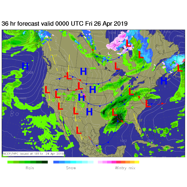
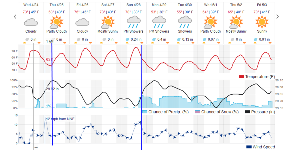
We're at our first broken record post of the Spring. We do have a weak front pushing into the state Thursday morning (Figure 1 - thin blue line). It will cool us down about 5-8 degrees over Wednesday's high temperature. This will also give us just a bit better moisture source and a focus for afternoon thundershowers to form in. Still - they won't give anyone. except a lucky few neighborhoods. any significant rain (Figure 2).

The Longer Range Forecast:

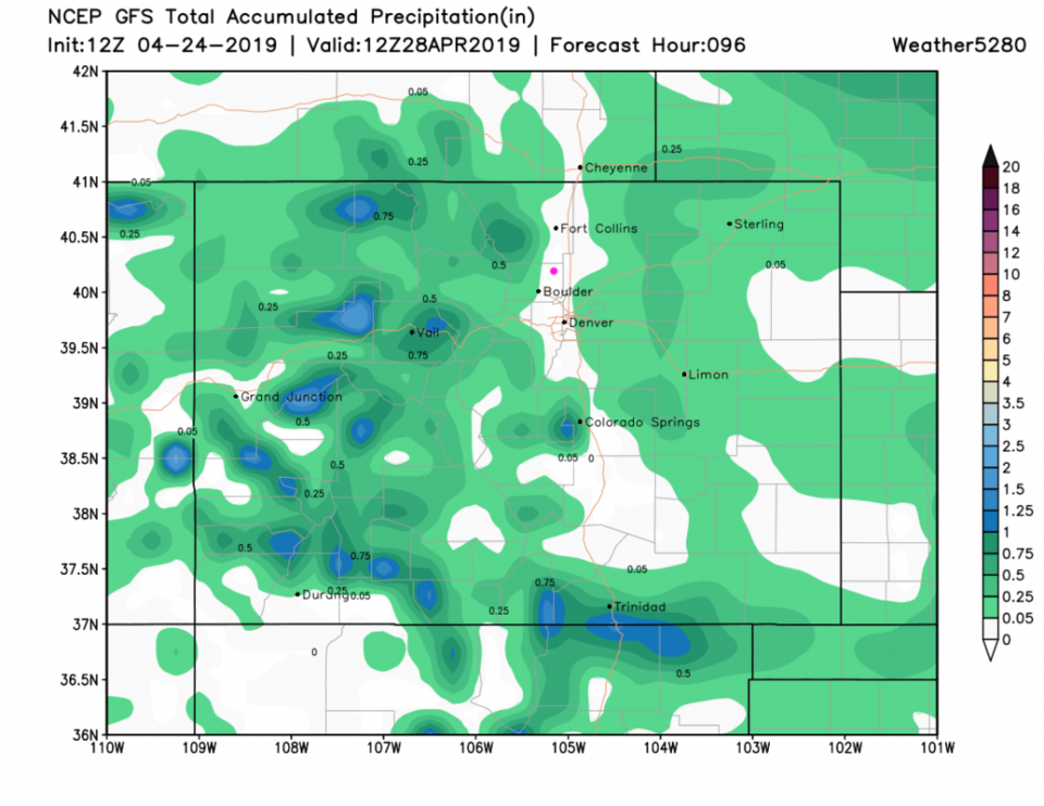
The mountains see daily shower activity while we remain mostly dry and warm on the Plains. Figure 3 shows the rainfall total through midday Sunday. I-25 looks like it is singled out for no rainfall. (My kids would say "no fair.") The more distant plains will see some showers.

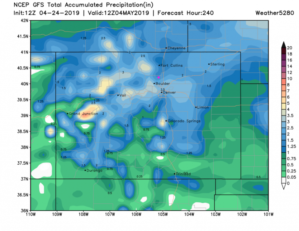
The next major change comes Sunday afternoon with a cool down and rainfall chances increasing a lot (Figure 2). The (fantasy?) rainfall total forecast from the GFS gives us 1.5-2 inches of rain over the next 10 days. Do not start placing bets on this yet.

Figure 1: The forecast surface map for Wednesday PM from NCEP.
Figure 2: the graphical forecast for the next 10 days for Longmont, CO from weatherunderground.com
Figure 3: the forecast accumulated precipitation map from the GFS and weather5280.com for Colorado through Sunday noon.
Figure 4: the forecast accumulated precipitation map from the GFS and weather5280.com for Colorado,over the next 10 days.

Current Weather

Sunny

Sunny

40°F

UV Index
1 Low
Pressure
30.1 Falling
Visibility
7 miles
Dewpoint
38 °F
Humidity
91%
Wind
W 1.1 mph
Gust
2.8 mph
Wind Chill
40 °F

Hourly Forecast

Today
7 AM
43°F
Intermittent clouds
Today
8 AM
45°F
Mostly sunny
Today
9 AM
51°F
Mostly sunny
Today
10 AM
57°F
Mostly sunny
Today
11 AM
62°F
Mostly sunny
Today
12 PM
66°F
Mostly sunny
Today
1 PM
70°F
Mostly sunny
Today
2 PM
73°F
Mostly sunny
Today
3 PM
74°F
Mostly sunny
Today
4 PM
76°F
Mostly sunny
Today
5 PM
74°F
Mostly sunny
Today
6 PM
72°F
Mostly sunny

7 Day Forecast

Mostly sunny

Wednesday

76 °F

Pleasant and warmer with sunshine and patchy clouds


Partly cloudy

Wednesday Night

42 °F

Patchy clouds


Mostly cloudy w/ t-storms

Thursday

76 °F

Becoming cloudy; breezy in the afternoon with a thunderstorm in spots


Thunderstorms

Thursday Night

47 °F

A thunderstorm in spots in the evening; otherwise, considerable cloudiness


Showers

Friday

71 °F

Mostly cloudy with a couple of showers


Cloudy

Friday Night

46 °F

Cloudy


Showers

Saturday

53 °F

Cloudy and cooler with a couple of showers


Rain

Saturday Night

39 °F

Cloudy with steady rain becoming intermittent


Cloudy

Sunday

59 °F

Cloudy with a stray thundershower in the afternoon


Partly cloudy

Sunday Night

38 °F

Partly cloudy


Sunrise and Sunset

Sunrise
6:08 AM
Sunset
7:49 PM

Based on AccuWeather data