Skip to content

Next Storm/Next Snow Forecast Discussion from the Cherrywood Observatory – April 24, 2019

This content was originally published by the Longmont Observer and is licensed under a Creative Commons license.

In Brief:

We have a stretch of 5 more days of mild weather with only a small chance of a thundershower most afternoons. A cool down with some rain showers return Monday/Tuesday, then we warm up but have continued shower chances next week.

Forecast Discussion:

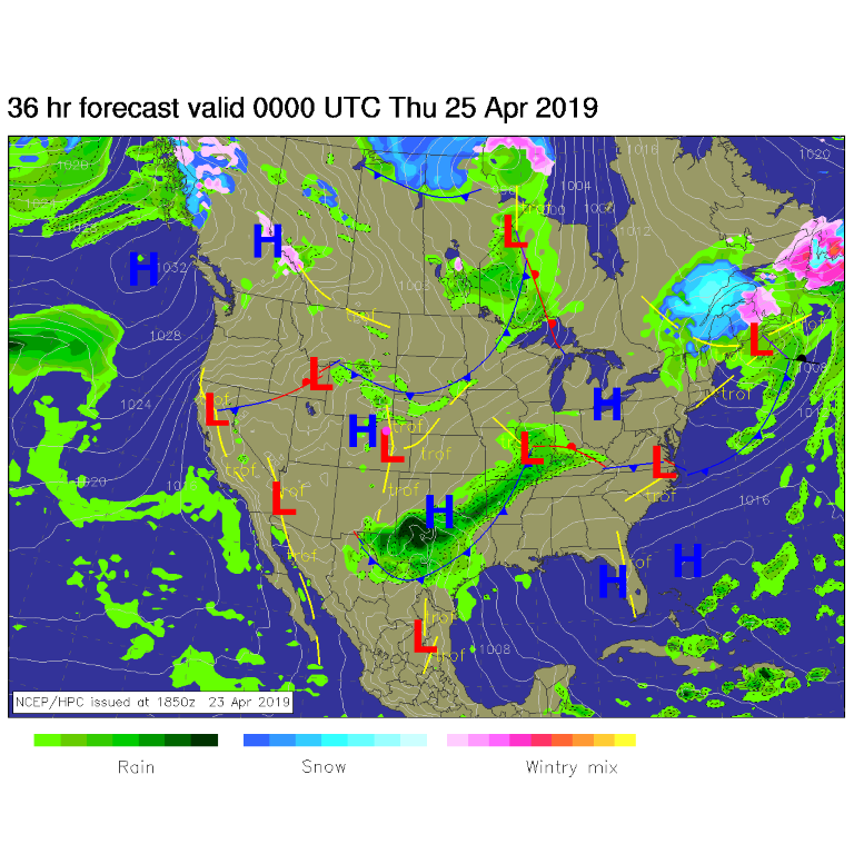
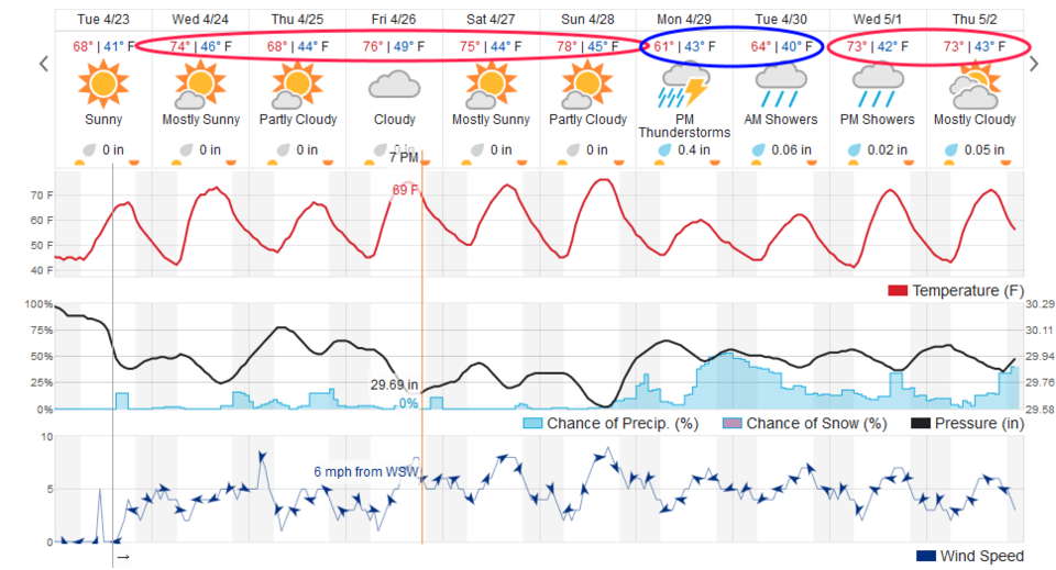
There aren't any organized storms around the state, but there is a weak lee trough (yellow line) just east of the mountains (Figure 1). There will be some moisture around and weak low level convergence along the Front Range. With day time heating- small thundershowers may pop up (Figure 2) and drift to the southeast on northwest flow aloft (not shown). Temperatures are very nice in the lower to middle 70's F this week.

The Longer Range Forecast:

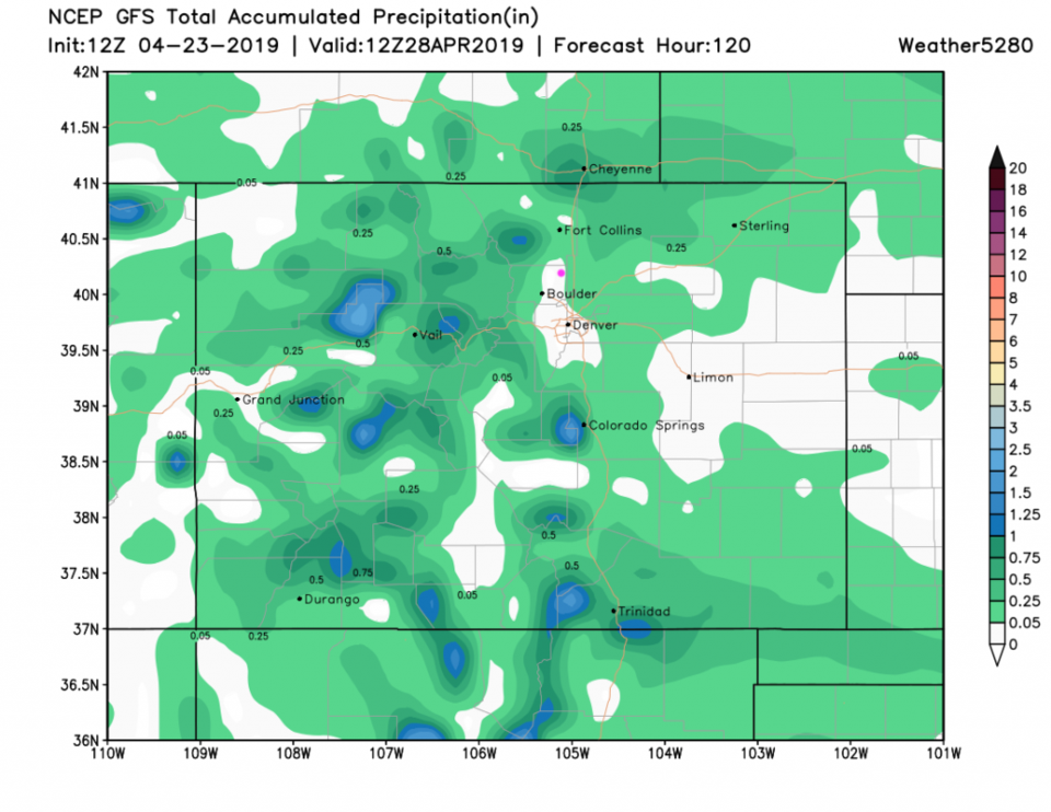
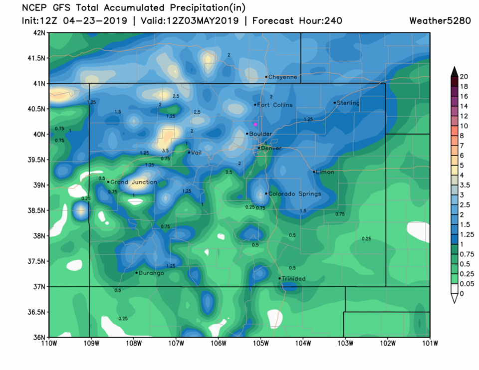
Over the next 5 days, there is a chance of a little bit of rain almost anywhere across the state (Figure 3). There are indications of cooler weather and rain beginning Sunday night (Figure 2) with rainfall over the next 10 days over 1.5" (Figure 4). Remember, we have seen the GFS get really excited many days out and then fade out on us. I wouldn't count on big rains yet.

Figure 1: The forecast surface map for Wednesday PM from NCEP.
Figure 2: the graphical forecast for the next 10 days for Longmont, CO from weatherunderground.com
Figure 3: the forecast accumulated precipitation map from the GFS and weather5280.com for Colorado,over the next 5 days.
Figure 4: the forecast accumulated precipitation map from the GFS and weather5280.com for Colorado,over the next 10 days.


Current Weather

Light rain

Light rain

55°F

UV Index
0 Low
Pressure
29.68 Rising
Visibility
8 miles
Dewpoint
40 °F
Humidity
57%
Wind
NNW 4.3 mph
Gust
11 mph
Wind Chill
55 °F

Hourly Forecast

Today
10 PM
54°F
Cloudy
Today
11 PM
54°F
Cloudy
Tomorrow
12 AM
53°F
Cloudy
Tomorrow
1 AM
52°F
Cloudy
Tomorrow
2 AM
51°F
Cloudy
Tomorrow
3 AM
51°F
Cloudy
Tomorrow
4 AM
50°F
Cloudy
Tomorrow
5 AM
51°F
Cloudy
Tomorrow
6 AM
51°F
Cloudy
Tomorrow
7 AM
52°F
Cloudy
Tomorrow
8 AM
56°F
Cloudy
Tomorrow
9 AM
59°F
Cloudy

7 Day Forecast

Mostly cloudy w/ showers

Thursday

72 °F

Turning cloudy, warm; an afternoon shower or two


Thunderstorms

Thursday Night

50 °F

A thunderstorm in parts of the area this evening; otherwise, considerable cloudiness and mild


Thunderstorms

Friday

70 °F

Mostly cloudy with a couple of thundershowers


Thunderstorms

Friday Night

43 °F

Cloudy with a couple of thundershowers


Rain

Saturday

46 °F

Chilly with periods of rain and a thunderstorm


Rain and snow

Saturday Night

39 °F

Cloudy with rain, mixed with a little snow late


Mostly cloudy

Sunday

59 °F

Mostly cloudy and warmer; a stray afternoon thundershower


Partly cloudy

Sunday Night

36 °F

Partly cloudy


Partly sunny

Monday

71 °F

Partly sunny, pleasant and warmer


Partly cloudy

Monday Night

42 °F

Partly cloudy


Sunrise and Sunset

Sunrise
6:07 AM
Sunset
7:50 PM

Based on AccuWeather data