Skip to content

Next Storm/Next Snow Forecast Discussion from the Cherrywood Observatory – April 12, 2019

This content was originally published by the Longmont Observer and is licensed under a Creative Commons license.

Forecast Discussion:

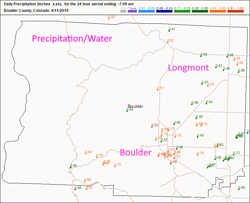
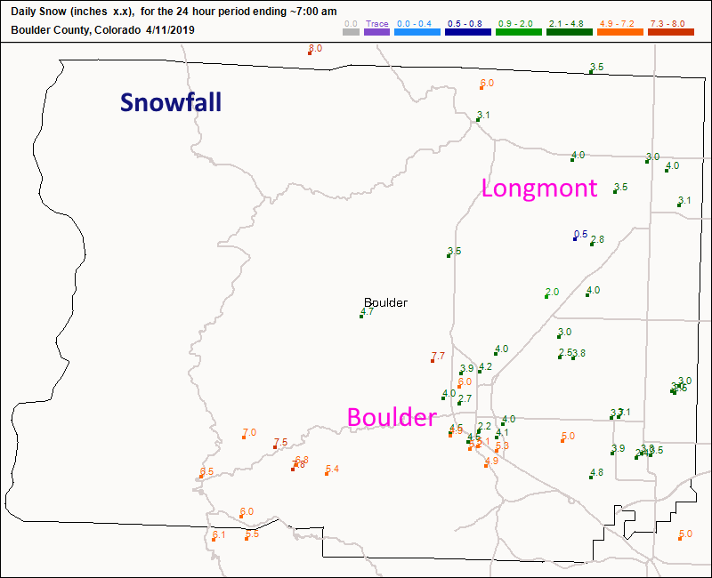
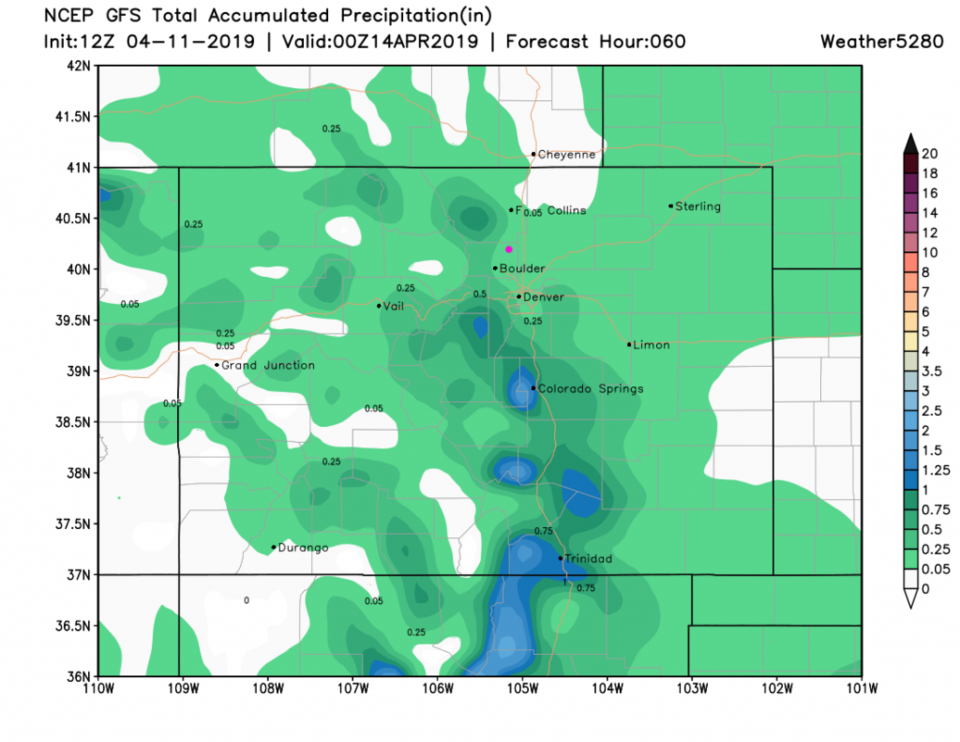
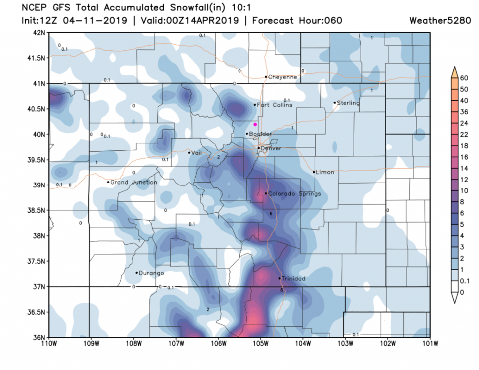
We received the snow. My personal forecast was for 1-4 inches (see NextDoor) in Longmont and we saw about 3-4 inches (Figure 2). This equate to almost 2/3rds of an inch of water (Figure 1). More drought busting goodness.

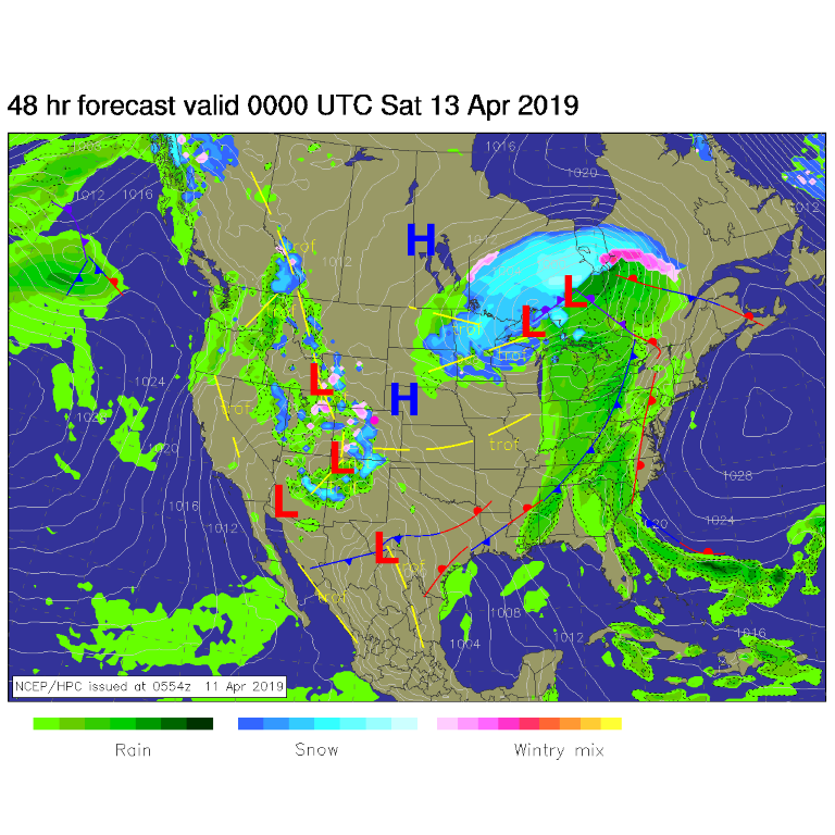
For Friday afternoon, the NEXT system is already moving in bringing snow to the mountains and afternoon rain showers that will turn to snow at night. This is not at all as vigorous as the last two storms, it is just a normal spring system is coming through (Figure 3). Rain chances taper off late morning Saturday.

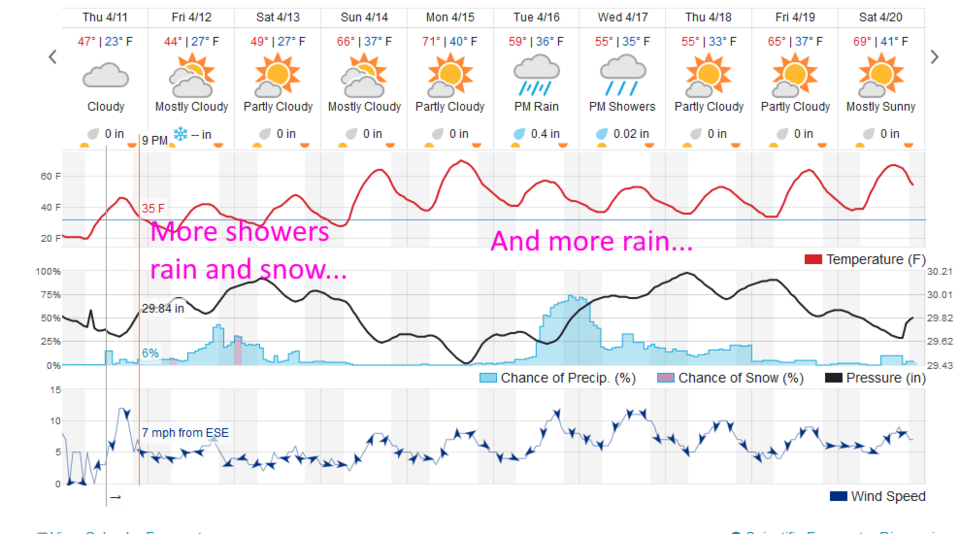
It looks like this next system will deliver .05 to .25 inch of water (Figure 4) and a coating to 1 inch of snow (Figure 5).

The longer range forecast:

We briefly visit 70F on Sunday before the Next Next system comes in cooling us down (but not really to freezing). We see rain showers Tuesday becoming an unsettled period of occasional showers through Thursday. More on that later (Figure 4)!

Figure 1: total new precipitation totals for Wednesday/Thursday up to 7am for Boulder county from CoCoRaHS.
Figure 2: total new snow totals for Wednesday/Thursday up to 7am for Boulder county from CoCoRaHS.
Figure 3: The forecast surface map for Fridaay PM from NCEP.
Figure 4: the graphical forecast for the next 10 days for Longmont, CO from weatherunderground.com
Figure 5: the forecast accumulated precipitation map from the GFS and weather5280.com for Colorado, over the next 3 days.
Figure 6: the forecast accumulated snowfall map from the GFS and weather5280.com for Colorado, over the next 3 days.


Current Weather

Rain

Rain

46°F

UV Index
0 Low
Pressure
29.82 Rising
Visibility
4 miles
Dewpoint
44 °F
Humidity
90%
Wind
NW 2.9 mph
Gust
6.2 mph
Wind Chill
45 °F

Hourly Forecast

Today
11 PM
48°F
Thunderstorms
Tomorrow
12 AM
47°F
Cloudy
Tomorrow
1 AM
47°F
Cloudy
Tomorrow
2 AM
46°F
Cloudy
Tomorrow
3 AM
45°F
Rain
Tomorrow
4 AM
45°F
Cloudy
Tomorrow
5 AM
45°F
Rain
Tomorrow
6 AM
44°F
Rain
Tomorrow
7 AM
44°F
Rain
Tomorrow
8 AM
43°F
Cloudy
Tomorrow
9 AM
42°F
Rain
Tomorrow
10 AM
41°F
Rain

7 Day Forecast

Mostly cloudy w/ t-storms

Friday

69 °F

Variable cloudiness with a couple of thundershowers this afternoon; gusty winds and small hail can accompany any downpour


Thunderstorms

Friday Night

41 °F

Cloudy; a couple of showers and a thunderstorm this evening followed by periods of rain late; gusty winds and small hail can accompany any downpour


Rain

Saturday

44 °F

Chilly with periods of rain and a thunderstorm; travel in the foothills and mountains will be slippery due to snow


Rain and snow

Saturday Night

36 °F

Cloudy with rain, mixed with a little snow late; travel in the foothills and mountains will be slippery due to snow


Mostly cloudy

Sunday

61 °F

Mostly cloudy and warmer


Intermittent clouds

Sunday Night

36 °F

A thunderstorm in spots in the evening; otherwise, partly cloudy


Partly sunny

Monday

71 °F

Partly sunny, pleasant and warmer


Partly cloudy

Monday Night

45 °F

Partly cloudy


Mostly sunny

Tuesday

73 °F

Pleasant with sunshine and patchy clouds


Partly cloudy

Tuesday Night

40 °F

Partly cloudy


Sunrise and Sunset

Sunrise
6:06 AM
Sunset
7:51 PM

Based on AccuWeather data