Skip to content

The Next Storm/Next Snow Forecast Discussion from the Cherrywood Observatory – January 11, 2018

This content was originally published by the Longmont Observer and is licensed under a Creative Commons license.

Forecast Discussion:

The front is sweeping down the Front Range this evening, Wednesday. We've had enough rainfall to wet the ground.  Hurray!

I'll update briefly in the morning with the rainfall and snowfall reports.

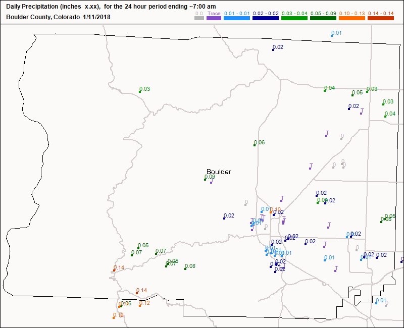
Rainfall update in Figure 1A... Longmont got enough water to make a puddle... well most of us did!

Figure 1a: Rainfall reports for the 24 hours ending 1/11/2018 at 7am from CoCoRaHS.

The longer range forecast:

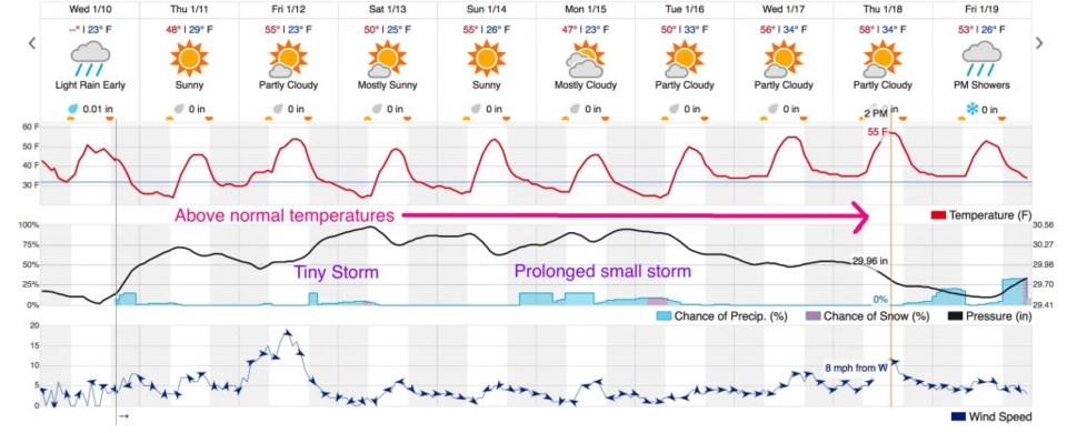
Temperatures go back above normal today and get even warmer beyond that for the next 10 days (Figure 1). There is a small storm passing on Friday and another prolonged unsettled period from Sunday PM to Tuesday... but neither are very wet or cold.

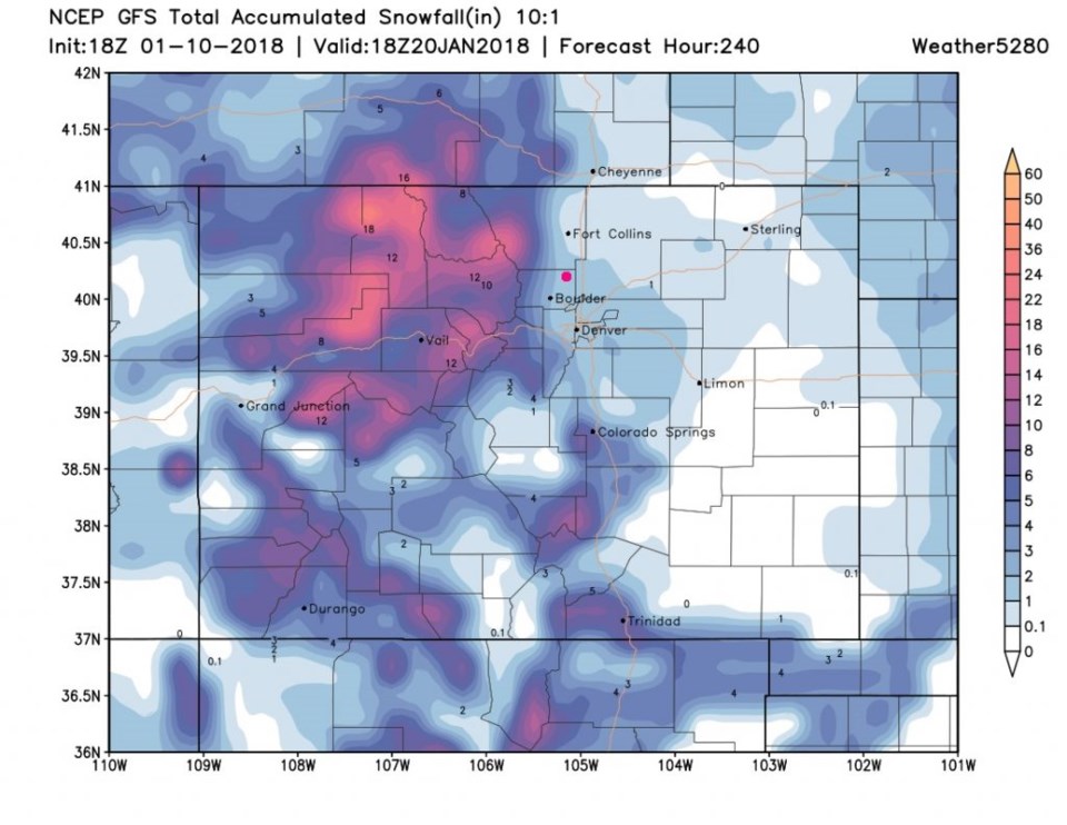
Just for fun - let's look at the GFS and the next 10 days. Figure 2 has Longmont as the pink dot- and it only gives us 1-2".   Someone needs to do some sort of mystical snow ritual for us!

Figure 1: The 10 day graphical forecast for Longmont. Notable storms and the temperature trend is here.

Figure 2: The GFS snowfall total forecast for the next 10 days. Longmont is the pink dot.

Current Weather

Mostly cloudy

Mostly cloudy

46°F

UV Index
0 Low
Pressure
30.11 Rising
Visibility
7 miles
Dewpoint
23 °F
Humidity
41%
Wind
NNW 3.8 mph
Gust
9.9 mph
Wind Chill
44 °F

Hourly Forecast

Today
6 AM
42°F
Partly cloudy
Today
7 AM
43°F
Partly sunny
Today
8 AM
45°F
Intermittent clouds
Today
9 AM
47°F
Intermittent clouds
Today
10 AM
50°F
Intermittent clouds
Today
11 AM
53°F
Intermittent clouds
Today
12 PM
56°F
Intermittent clouds
Today
1 PM
58°F
Intermittent clouds
Today
2 PM
60°F
Mostly cloudy
Today
3 PM
61°F
Cloudy
Today
4 PM
63°F
Cloudy
Today
5 PM
61°F
Cloudy

7 Day Forecast

Mostly cloudy

Tuesday

63 °F

Mostly cloudy and cooler


Partly cloudy w/ t-storms

Tuesday Night

39 °F

An evening thundershower; otherwise, partly cloudy


Mostly sunny

Wednesday

76 °F

Pleasant and warmer with sunshine and patchy clouds


Partly cloudy

Wednesday Night

41 °F

Patchy clouds


Mostly cloudy

Thursday

75 °F

Turning cloudy, warm; breezy, a thunderstorm around in the afternoon


Cloudy

Thursday Night

48 °F

Considerable cloudiness with a thundershower in parts of the area


Showers

Friday

69 °F

Mostly cloudy with a couple of showers


Thunderstorms

Friday Night

46 °F

Cloudy; thundershowers in the evening, then late-night rain


Showers

Saturday

53 °F

Low clouds and cooler with a couple of showers


Rain

Saturday Night

41 °F

Occasional rain and drizzle


Sunrise and Sunset

Sunrise
6:10 AM
Sunset
7:48 PM

Based on AccuWeather data