Skip to content

UPDATED: The Next Storm/Next Snow Forecast Discussion from the Cherrywood Observatory – February 11 , 2018

This content was originally published by the Longmont Observer and is licensed under a Creative Commons license.

Forecast Discussion:

Sunday AM Update:

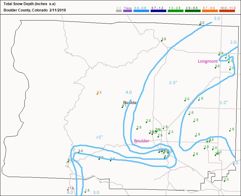
Figure 4 is the snowfall reports map from CoCoRaHS.  I drew some quick and dirty isohyets (line of equal precipitation - snowfall in this case). The 2 inch line cut Longmont in half.  Parts of Boulder reached 5 inches of snow (Figure 4).

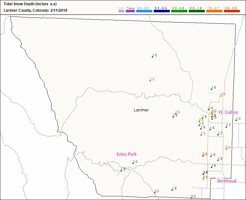
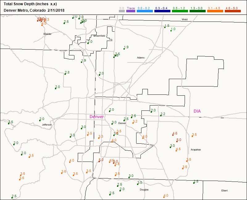
Ft Collins received 1.5-2 inches of snow. Berthoud about 1.5 inches. Estes Park only 1-1.5 inches (in the reports submitted by midday; Figure 5). North Denver was also low in the 1-2 inch area while the southern side of the Metro picked up a much nicer 3-5 inches (Figure 6).

Figure 4: CoCoRaHS snowfall reports as of 7am today (Sunday). Blue lines are the 2, 3 and 4 inch contours based on this data. This is Boulder County.

Figure 5: CoCoRaHS snowfall reports as of 7am today (Sunday). This is Larimer County.

Figure 6: CoCoRaHS snowfall reports as of 7am today (Sunday). This is the Denver Metro.

Previous Forecast:

The current storm is underway, so this discussion will be brief.  I'll upload Sunday morning snowfall report maps as an update midday Sunday.

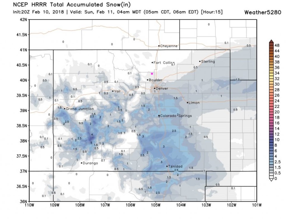
Figure 1 shows that the models are still expecting one more burst of snow in the early evening before skies clear Saturday night.  From my latest look at the radar - I don't see this band of snow upstream anywhere.  Figure 2 is the rapid update model HRRR and snow through Sunday morning. Longmont is on the edge of 0 to 1/2 inch more.  The main activity has shifted south.

Figure 1: 10 day graphical forecast for Longmont from weatherunderground.com - next three 'storms' circled in pink.

Figure 2: The total snowfall forecast from Saturday midday to Sunday early morning from the HRRR model and weather5280.com

The longer range forecast:

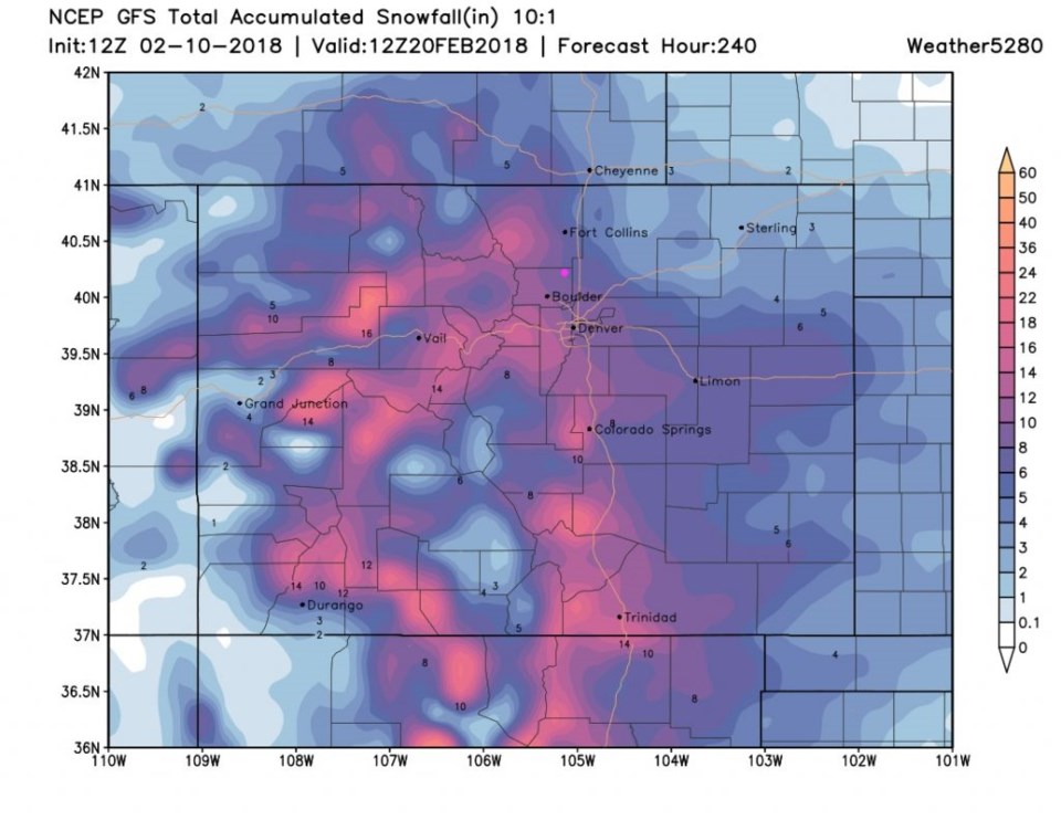
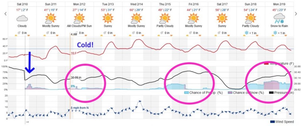
Figure 1 shows the weather 10 days out... there are low chances of precipitation Monday, but temperatures go quite low for a day.  We see chances of snow/rain Thursday into Friday and again Sunday into Monday. Only the most distant storm looks significant (and we know what usually happens- this year- to good looking model-storms). Figure 3 reflects that idea by giving us a total of about 8 inches of snow over the next 10 days.  I would be really surprised to see that much occur out of these next three unsettled periods. (Nice snow in the mountains though!).

Figure 3: The total snowfall forecast from Saturday midday to Feb 20th - 10 days out fom the GFS model and weather5280.com

Current Weather

Partly sunny

Partly sunny

51°F

UV Index
1 Low
Pressure
29.68 Rising
Visibility
7 miles
Dewpoint
27 °F
Humidity
39%
Wind
W 8.5 mph
Gust
17 mph
Wind Chill
51 °F

Hourly Forecast

Today
8 PM
49°F
Showers
Today
9 PM
47°F
Partly cloudy
Today
10 PM
45°F
Partly cloudy
Today
11 PM
43°F
Partly cloudy
Tomorrow
12 AM
41°F
Mostly clear
Tomorrow
1 AM
40°F
Mostly clear
Tomorrow
2 AM
39°F
Mostly clear
Tomorrow
3 AM
38°F
Mostly clear
Tomorrow
4 AM
37°F
Mostly clear
Tomorrow
5 AM
36°F
Partly cloudy
Tomorrow
6 AM
35°F
Partly sunny
Tomorrow
7 AM
37°F
Intermittent clouds

7 Day Forecast

Partly sunny w/ showers

Tuesday

60 °F

Times of clouds and sun with a couple of brief showers beginning at midday; windy


Partly cloudy

Tuesday Night

35 °F

A shower in spots this evening; otherwise, partly cloudy and colder; there can be frost in the normally colder spots


Intermittent clouds

Wednesday

58 °F

Cool with times of clouds and sun


Mostly cloudy w/ showers

Wednesday Night

39 °F

Increasing clouds with a shower in spots late


Partly sunny w/ showers

Thursday

56 °F

Times of clouds and sun with a couple of showers; cool


Partly cloudy

Thursday Night

40 °F

Partly cloudy


Mostly cloudy

Friday

63 °F

Mostly cloudy and warmer


Clear

Friday Night

42 °F

Clear


Mostly sunny

Saturday

68 °F

Mostly sunny


Mostly clear

Saturday Night

43 °F

Mainly clear


Sunrise and Sunset

Sunrise
5:52 AM
Sunset
8:02 PM

Based on AccuWeather data