Skip to content

The Next Storm/Next Snow Forecast Discussion from the Cherrywood Observatory – December 7, 2017

This content was originally published by the Longmont Observer and is licensed under a Creative Commons license.

Forecast Discussion:

I'll mainly work with the scattered snow showers today.  We will have two periods of instability/lift over the state, one in the morning and another in the afternoon. With reinforced cold air, we'll be cold enough for snow. Even if it is only snow flurries in the air.  The favorable mountain slopes may see up to 4" of snow, but nothing measurable should build up on the Plains or along I-25.  It will be cold and blustery though, with less sun than we saw on Wednesday.

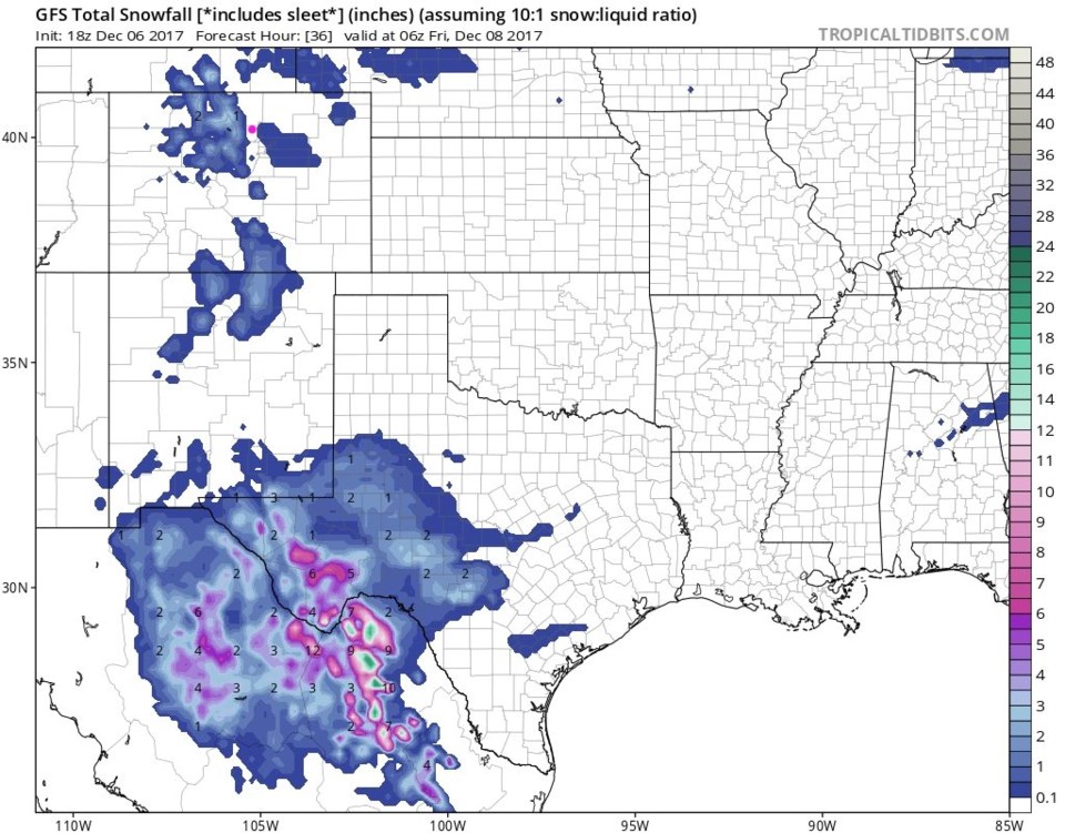
Figure 1 shows that there will be scattered showers all across the northern mountains and NE plains.  Anyone around might see a few periods of light snow.

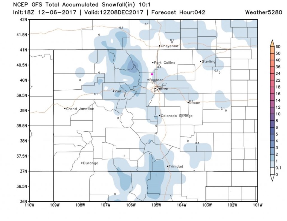
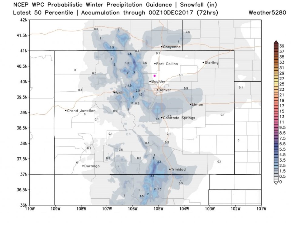
Figure 2 is the GFS take. The gap along I-25 seems to be the snow-depressing effect of down-slope flow, but snow flurries are still possible in Longmont.  Figure 3 hints that a coating is possible IF everything went right for snow for us.

Figure 1: GFS run from tropicaltidbits.com snowfall accumulation between Wed PM and Thur PM.

Figure 2: GFS run from weather5280.com snowfall accumulation between Wed PM and Fri AM.

Figure 3: WPC 50 percentile run from weather5280.com snowfall accumulation between Wed PM and Fri AM.

The Longer Range Forecast:

The ridge will build in from the west - which will give California a break from the destructive Santa Ana winds, and will warm us nicely for a beautiful weekend.  More on that later!

Current Weather

Clear

Clear

61°F

UV Index
0 Low
Pressure
29.9 Rising
Visibility
7 miles
Dewpoint
42 °F
Humidity
50%
Wind
NNW 3.5 mph
Gust
6.6 mph
Wind Chill
61 °F

Hourly Forecast

Today
10 PM
58°F
Intermittent clouds
Today
11 PM
55°F
Mostly cloudy
Tomorrow
12 AM
53°F
Intermittent clouds
Tomorrow
1 AM
51°F
Partly cloudy
Tomorrow
2 AM
49°F
Mostly clear
Tomorrow
3 AM
47°F
Mostly clear
Tomorrow
4 AM
45°F
Clear
Tomorrow
5 AM
43°F
Mostly clear
Tomorrow
6 AM
41°F
Mostly clear
Tomorrow
7 AM
45°F
Partly sunny
Tomorrow
8 AM
49°F
Partly sunny
Tomorrow
9 AM
55°F
Partly sunny

7 Day Forecast

Mostly sunny

Wednesday

75 °F

Mostly sunny, pleasant and warmer


Partly cloudy

Wednesday Night

41 °F

Patchy clouds


Mostly cloudy w/ t-storms

Thursday

75 °F

Turning cloudy, warm; breezy, a thunderstorm around in the afternoon


Thunderstorms

Thursday Night

49 °F

A thunderstorm in spots in the evening; otherwise, considerable cloudiness


Showers

Friday

70 °F

Mostly cloudy with a couple of showers


Thunderstorms

Friday Night

46 °F

Cloudy with showers and thunderstorms


Rain

Saturday

50 °F

Chilly with periods of rain


Rain and snow

Saturday Night

39 °F

Cloudy with rain, mixed with a little snow late


Mostly cloudy

Sunday

59 °F

Mostly cloudy with a stray thundershower in the afternoon


Partly cloudy

Sunday Night

36 °F

Partly cloudy


Sunrise and Sunset

Sunrise
6:08 AM
Sunset
7:49 PM

Based on AccuWeather data