This content was originally published by the Longmont Observer and is licensed under a Creative Commons license.
By John Ensworth
For Fun, let’s see how the cloud forecast for the eclipse panned out. I captured the satellite picture just after the end of the eclipse. I outlined the partly cloudy areas in yellow and the more densely clouded areas in red.

| Percent Cloud Cover Forecasted for | Sun 8/13 | Mon 8/14 | Tue 8/15 | Wed 8/16 | Thur 8/17 | Fri 8/18 | Sat 8/19 | Sun 8/20 | Actual | score |
| Teton Village | 26% | 30% | 12% | 41% | 54% | 44% | 26% | 21% | 10% | Good |
| Casper | 9% | 27% | 38% | 43% | 15% | 2% | 1% | 0% | 0% | Excellent |
| Glendo | 13% | 31% | 33% | 38% | 24% | 8% | 4% | 6% | 0% | Very Good |
| Lusk | 9% | 26% | 22% | 23% | 14% | 24% | 29% | 10% | 0% | Very Good |
| Alliance | 7% | 36% | 39% | 37% | 23% | 36% | 78% | 70% | 10% | Poor |
| Longmont | 23% | 45% | 22% | 34% | 54% | 16% | 34% | 61% | 25% | Fair |
A Map Version of Cloud Forecasts
NCEP Forecast from Weather5280.com folks. Source: https://www.weather5280.com/models
* Poor, far too many clouds were forecasted.

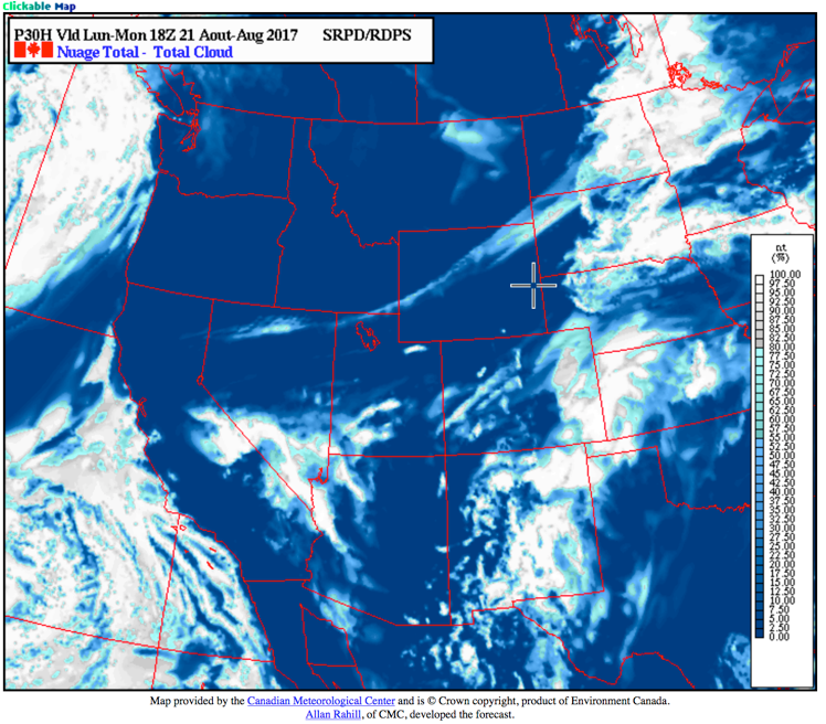
Clear Sky Chart clouds from the Canadian Meteorological Center. Source: http://cleardarksky.com/csk/
* Fair, Clouds were too far west in forecast for Nebraska and the Dakotas. NW Colorado was cloudier than this forecast. That swoop through Wyoming didn’t materialize.

North American Model clouds. Source: http://weather.rap.ucar.edu/model/
- Poor, there were forecasted too many clouds across Colorado, Nebraska and the Dakotas. And that Wyoming swoop didn’t happen.

RAP model clouds. Source: http://weather.rap.ucar.edu/model/
- Good, the Montana to North Dakota clouds didn’t materialize, but across Wyoming and Nebraska, it was pretty good except for northern Nebraska.

- Pretty Poor, this was really cloud heavy everywhere, and it had that mystery swoop across Wyoming as well.
Skippy Sky cloud forecast from Australia. Source: http://weather.rap.ucar.edu/model/ (I’ll include the entire eclipse path.)

*** This feature will run as close to daily as possible in this location on the Longmont Observer. This article will provide a brief discussion concerning the ‘why’ behind the weather with a focus on severe weather, unusual weather, and snow (especially trying to predict snow depth and its human impact in Longmont).***
Bio:
John Ensworth works from Longmont as the Principle Investigator for the NASA Science Mission Directorate Earth and space science education product review through the IGES (The Institute for Global Environmental Strategies – www.strategies.org) . He is in his 14thyear running this review. He is an astronomer (from the 2nd grade onward) and became a meteorologist (in the 5th grade) when a thunderstorm in Arizona rained on his telescope when the weather service had only forecasted a 10% chance of rain. He has college degrees in physics and astronomy and climatology and a graduate degree in meteorology and earth science. He lectures at the Little Thompson Observatory in Berthoud, the Estes Park Memorial Observatory in Estes Park, and for a number of online universities. He built and runs a backyard observatory near Pace and 17th in northeast Longmont where he has lived for 8 years with his wife, daughter, son, and two cats. Invitations to open house nights at this observatory, LTO, and EPMO will be posted with future discussions when they are scheduled.
Forecasting severe weather and snow amounts via text lead to this column. He began texting friends about the weather right after the September 2013 flood. The readers of this column will, hopefully, keep him honest in what he ‘thought’ he had forecasted for ‘the most recent’ storm.


